Canadian, Texas | |
---|---|
Coordinates: 35°54′39″N100°23′00″W / 35.91083°N 100.38333°W | |
Country | United States |
State | Texas |
County | Hemphill |
Area | |
• Total | 1.30 sq mi (3.36 km2) |
• Land | 1.30 sq mi (3.36 km2) |
• Water | 0.00 sq mi (0.00 km2) |
Elevation | 2,431 ft (741 m) |
Population (2020) | |
• Total | 2,339 |
• Density | 1,800/sq mi (700/km2) |
Time zone | UTC-6 (Central (CST)) |
• Summer (DST) | UTC-5 (CDT) |
ZIP code | 79014 |
Area code | 806 |
FIPS code | 48-12412 [3] |
GNIS feature ID | 2409973 [2] |
Website | www |
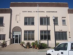
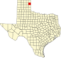
Canadian is a city in, and the county seat of, Hemphill County, Texas, United States. [4] The population was 2,339 at the 2020 census, [5] down from 2,649 in 2010. [6] It is named for the nearby Canadian River, a tributary of the Arkansas River. Incorporated in 1908, Canadian is sometimes called "the oasis of the High Plains". Canadian is on the eastern side of the Texas Panhandle, close to the border with Oklahoma.
In 1887 the city government began. [7]
A portion of the Tom Hanks movie Cast Away was filmed in Canadian. [8]
In February 2024, most of the town was in the path of the 1,058,482 acre (428,352 ha) Smokehouse Creek Fire, which charred most of the town. [9] No fatalities have been reported within Canadian.
Canadian is northwest of the center of Hemphill County, 1 mile (1.6 km) south of the Canadian River, where it is joined by Red Deer Creek. U.S. Routes 60 and 83 pass through the center of town as Second Street. US 60 leads northeast 162 miles (261 km) to Enid, Oklahoma, and southwest 101 miles (163 km) to Amarillo, while US 83 leads northwest 46 miles (74 km) to Perryton and south 51 miles (82 km) to Shamrock.
According to the U.S. Census Bureau, Canadian has a total area of 1.3 square miles (3.4 km2), all land. [6]
Nic Garcia of the Texas Tribune characterized Canadian as having "a sense of isolation." [7]
Canadian has a cool semi-arid climate (Köppen BSk) that is almost wet enough to qualify as a humid subtropical climate (Cfa). [10]
Climate data for Canadian, Texas | |||||||||||||
---|---|---|---|---|---|---|---|---|---|---|---|---|---|
Month | Jan | Feb | Mar | Apr | May | Jun | Jul | Aug | Sep | Oct | Nov | Dec | Year |
Record high °F (°C) | 85 (29) | 90 (32) | 95 (35) | 99 (37) | 105 (41) | 112 (44) | 111 (44) | 110 (43) | 108 (42) | 101 (38) | 90 (32) | 84 (29) | 112 (44) |
Mean daily maximum °F (°C) | 47 (8) | 54 (12) | 62 (17) | 71 (22) | 79 (26) | 88 (31) | 94 (34) | 93 (34) | 85 (29) | 74 (23) | 59 (15) | 48 (9) | 71 (22) |
Mean daily minimum °F (°C) | 19 (−7) | 23 (−5) | 30 (−1) | 41 (5) | 52 (11) | 62 (17) | 66 (19) | 65 (18) | 56 (13) | 43 (6) | 30 (−1) | 21 (−6) | 42 (6) |
Record low °F (°C) | −14 (−26) | −14 (−26) | −4 (−20) | 15 (−9) | 24 (−4) | 39 (4) | 47 (8) | 45 (7) | 27 (−3) | 11 (−12) | −2 (−19) | −13 (−25) | −14 (−26) |
Average precipitation inches (mm) | 0.46 (12) | 0.75 (19) | 1.70 (43) | 1.72 (44) | 3.75 (95) | 3.33 (85) | 2.19 (56) | 2.36 (60) | 2.36 (60) | 1.47 (37) | 0.94 (24) | 0.69 (18) | 21.72 (553) |
Average snowfall inches (cm) | 3.80 (9.7) | 2.40 (6.1) | 1.90 (4.8) | 0.30 (0.76) | 0 (0) | 0 (0) | 0 (0) | 0 (0) | 0 (0) | 0.10 (0.25) | 1.00 (2.5) | 7.00 (17.8) | 16.50 (41.9) |
Source: [11] |
Census | Pop. | Note | %± |
---|---|---|---|
1910 | 1,648 | — | |
1920 | 2,187 | 32.7% | |
1930 | 2,068 | −5.4% | |
1940 | 2,151 | 4.0% | |
1950 | 2,700 | 25.5% | |
1960 | 2,239 | −17.1% | |
1970 | 2,292 | 2.4% | |
1980 | 3,491 | 52.3% | |
1990 | 2,417 | −30.8% | |
2000 | 2,233 | −7.6% | |
2010 | 2,649 | 18.6% | |
2020 | 2,339 | −11.7% | |
1930-2000, [12] |
Race | Number | Percentage |
---|---|---|
White (NH) | 1,267 | 54.17% |
Black or African American (NH) | 1 | 0.04% |
Native American or Alaska Native (NH) | 15 | 0.64% |
Asian (NH) | 6 | 0.26% |
Some Other Race (NH) | 4 | 0.17% |
Mixed/Multi-Racial (NH) | 88 | 3.76% |
Hispanic or Latino | 958 | 40.96% |
Total | 2,339 |
As of the 2020 United States census, there were 2,339 people, 908 households, and 627 families residing in the city.
As of the census [3] of 2000, 2,233 people, 869 households, and 625 families resided in the city. The population density was 1,731.0 inhabitants per square mile (668.3/km2). The 1,047 housing units averaged 811.6 per square mile (313.4/km2). The racial makeup of the city was 88.94% White, 0.22% African American, 0.76% Native American, 0.13% Asian, 0.04% Pacific Islander, 9.00% from other races, and 0.90% from two or more races. Hispanics or Latinos of any race were 18.76% of the population.
Of the 869 households, 35.0% had children under the age of 18 living with them, 60.9% were married couples living together, 7.6% had a female householder with no husband present, and 28.0% were not families. About 26.1% of all households were made up of individuals, and 13.5% had someone living alone who was 65 years of age or older. The average household size was 2.52 and the average family size was 3.04.
In the city, the population was distributed as 27.5% under the age of 18, 7.2% from 18 to 24, 26.8% from 25 to 44, 22.9% from 45 to 64, and 15.5% who were 65 years of age or older. The median age was 38 years. For every 100 females, there were 91.7 males. For every 100 females age 18 and over, there were 87.0 males.
The median income for a household in the city was $31,929, and for a family was $38,676. Males had a median income of $30,240 versus $17,083 for females. The per capita income for the city was $16,384. About 12.3% of families and 14.1% of the population were below the poverty line, including 19.4% of those under age 18 and 16.4% of those age 65 or over.
The City of Canadian is served by the Canadian Independent School District.
The Canadian Record was a weekly newspaper that ended publication in 2023. [14]
In 2023 Nic Garcia described the character of the residents as "tough but empathetic. Forward-looking yet conservative." [7]
Wheeler County is a county located in the U.S. state of Texas. As of the 2020 census, its population was 4,990. Its county seat is Wheeler. The county was formed in 1876 and organized in 1879. It is named for Royall Tyler Wheeler, a chief justice of the Texas Supreme Court.
Stonewall County is a county located in the U.S. state of Texas. As of the 2020 census, its population was 1,245. Its county seat is Aspermont. The county was created in 1876 and organized in 1888. It is named for Stonewall Jackson, a general of the Confederate States Army.
Sabine County is a county located on the central eastern border of the U.S. state of Texas. As of the 2020 census, its population was 9,894. The county was organized on December 14, 1837, and named for the Sabine River, which forms its eastern border.
Roberts County is a county located in the U.S. state of Texas. As of the 2020 census, its population was 827, making it the eighth-least populous county in Texas. Its county seat is Miami, which is also the county's only incorporated community. The county was created in 1876 and organized in 1889. It is named for Oran Milo Roberts, a governor of Texas. Roberts County is one of four prohibition counties in the state of Texas.
Ochiltree County is a county located in the panhandle of the U.S. state of Texas. As of the 2020 census, its population was 10,015. The county seat is Perryton. The county was created in 1876 and organized in 1889. and is named for William Beck Ochiltree, who was an attorney general of the Republic of Texas. It was previously one of 30 prohibition or entirely dry counties in the state of Texas.
Lipscomb County is a county located in the U.S. state of Texas. As of the 2020 census, its population was 3,059. Its county seat is Lipscomb. The county was created in 1876 and organized in 1887. It is named for Judge Abner Smith Lipscomb, a secretary of state of the Republic of Texas.
Hemphill County is a county located in the U.S. state of Texas. As of the 2020 census, its population was 3,382. The county seat and only incorporated community in the county is the city of Canadian. The county was created in 1876 and organized in 1887. It is named for John Hemphill, a judge and Confederate congressman. Hemphill County is the most recent Texas county to permit alcohol sales.
Hardeman County is a county located in the U.S. state of Texas. As of the 2020 census, its population was 3,549. The county seat and largest city is Quanah. The county was created in 1858 and later organized in 1884. It is named for two brothers, Bailey Hardeman and Thomas Jones Hardeman, early Texas politicians and legislators. Hardeman County was one of 46 prohibition or entirely dry counties in the state of Texas until November 2006, when voters approved referendums to permit the legal sale of alcoholic beverages for on- and off-premises consumption.
Gray County is a county located in the U.S. state of Texas. As of the 2020 census, its population was 21,227. The county seat is Pampa. The county was created in 1876 and later organized in 1902. is named for Peter W. Gray, a Confederate lawyer and soldier in the American Civil War.
Collingsworth County is a county in the U.S. state of Texas. As of the 2020 census, its population was 2,652. Its county seat is Wellington. The county was created in 1876 and later organized in 1890. It is named for James Collinsworth, a signer of the Texas Declaration of Independence and first chief justice of the Republic of Texas. Collingsworth County was one of 30 prohibition, or entirely dry, counties in Texas, but a vote in 2017 changed this law.
Childress County is a county located in the U.S. state of Texas. As of the 2020 census, its population was 6,664. The county seat is Childress. The county was created in 1876 and later organized in 1887. It is named for George Campbell Childress, the author of the Texas Declaration of Independence.
Texas County is a county located in the panhandle of the U.S. state of Oklahoma. Its county seat is Guymon. As of the 2020 census, the population was 21,384. It is the second largest county in Oklahoma, based on land area, and is named for Texas, the state that adjoins the county to its south. Texas County comprises the Guymon, OK Micropolitan Statistical Area. The county economy is largely based on farming and cattle production. It is one of the top-producing counties in the U.S. for wheat, cattle, and hogs. It also lies within the noted Hugoton-Panhandle natural gas field.
Panhandle is the county seat of Carson County, Texas, United States. The population of the town was 2,378 at the 2020 census. Panhandle is part of the Amarillo metropolitan statistical area.
Paducah is a town in Cottle County, Texas, United States. The population was 1,063 at the 2020 census, down from 1,186 in 2010. It is the county seat of Cottle County. It is just south of the Texas Panhandle and east of the Llano Estacado.
Clarendon is a city in Donley County, Texas, United States. Its population was 1,877 at the 2020 census. The county seat of Donley County, Clarendon is located on U.S. Highway 287 in the Texas Panhandle, 60 miles (97 km) east of Amarillo.
Pampa is a city in Gray County, Texas, United States. Its population was 16,867 as of the 2020 census. Pampa is the county seat of Gray County and is the principal city of the Pampa micropolitan statistical area, which includes both Gray and Roberts Counties. Pampa is named after the Pampas Lowlands in Argentina, Uruguay, and southern Brazil.
Seth Ward is an unincorporated community and census-designated place (CDP) in Hale County, Texas, United States. The population was 2,025 at the 2010 census.
Canyon is a city in, and the county seat of, Randall County, Texas, United States. The population was 14,836 at the 2020 census. It is part of the Amarillo, Texas, metropolitan statistical area. Canyon is the home of the Panhandle–Plains Historical Museum, and the outdoor musical drama Texas.
Hemphill is a city in and the county seat of Sabine County, Texas, United States. The population was 1,029 at the 2020 census. It is the county seat of Sabine County. It is located on State Highway 87 at the junction of State Highway 184, and is surrounded by the Sabine National Forest and the Toledo Bend Reservoir.
Fritch is a city in Hutchinson and Moore Counties in the U.S. state of Texas. The population was 1,859 at the 2020 census.