Umaidpur

Last updated

Umaidpur
Village
India Bihar location map.svg
Red pog.svg
Umaidpur
Village in Bihar State of India
Coordinates: 25°46′45″N85°41′00″E / 25.779036°N 85.683340°E / 25.779036; 85.683340
CountryIndia
State Bihar
District Samastipur
Parliamentary constituency Ujiarpur
Assembly constituency Morwa
Government
  Body Gram Panchayat
Population
 (2011)
  Total1,960
Languages
  OfficialHindi, English, Urdu, Maithali
Time zone UTC+5.30 (IST)
PIN
848121
Area code STD Code 06274
Website http://umaidpur.com/

Umaidpur is one of the villages of Morwa Dakshni Gram panchayat [1] in Morwa (Vidhan Sabha constituency) [2] in the Samastipur District of Bihar State, India. [3]

Contents

History

The current history can be traced back to the end of the 16th century when the area was a part of Singh Dynasty and was ruled by Vikramjeet Singh of Sarmera. During the Mughal period of 1571-1611, It was a huge empire and was ruled by Vikramjeet Singh of Sarmera. Then after his death the empire was in 1614 the empire was destroyed due to civil war and heavy rainfall. Then in 1720 the descendants of Vikramjeet Singh of Sarmera established Sarmera Estate.

In 1770, the East India Company defeated Sarmera Estate and occupied the village. Then the ruler of Sarmera Estate, Bhim Lal Singh of Sarmera broke his estate into many small parts. Then this area became a part of the Presidency during the British Raj in 1778.

In the early 19th century, Umaidpur became a part of the newly created province of Bihar. The regional office was Harsingpur. Kothi and T.I. Pal was the officer representative on behalf of the British. Throughout British rule, all the villages were part of the estates run by independent Zamindars, calling themselves a Raja, or directly ruled by the British Raj. [4] [5] [6] The arid lands of Umaidpur was part of the Narhan Estate and the Jaintpur Estate, Muzaffarpur. The British cultivated indigo, sugarcane, poppy, and tobacco. [4] Land revenue was collected with the help of Jeth Rayaits for the Tehsildar (revenue collector). Sukkan Roy was the Jeth Rayait for Narhan Estate, [5] whereas Ram Pratap Roy was the Jeth Rayait for the Jaintpur Estate. Chullahai Hazari was the Brahil, whose responsibility was to inform villagers to come at the Jeth Rayait's house to pay land revenues.

When the British left India, they sold all their land possessions to Janak Kishore Prasad, including Harsinghpur Kothi. Presently, Umaidpur is the home of a former Mukhiya (1994-1996; 2001-2005), Sukhdeo Roy, the son of Sukkan Roy.

Demographics

The total land of the Umaidpur village is around 300 bighas. In Samastipur district and Patna, one bigha is equivalent to 20 Kattha (1361 ft2 or 126.44 m2); one Kattha is sub-divided in 20 Dhur and one Dhur is approximately 68.06 ft2 (6.321 m2). According to the 2011 Census of India, Umaidpur village (vilcode-236729) had around 329 households. The total population of the village is around 1,960 (male 1034 and female 926). [7]

Geography and climate

Time zone: IST (UTC+5:30)
Elevation / Altitude: 51 meters above sea level.

Location

Umaidpur is located in the far south-west of Samastipur District, bordered to the north and east by Naua Chak village, to the south by Jitwarpur Kumhara and in the west by Morwa. The post office is at Bhagwatpur. The PIN code is 848135 and the telephone STD code is 06274. The nearest banks are State Bank of India in Tajpur Morwa (006562) and Central Bank of India in Sarairanjan (280058).

Climate

Umaidpur experiences six distinct seasons. Typical summer months are from May to July, with maximum temperatures ranging from 35 °C to 45 °C. May and June are the warmest months in Umaidpur; although summer doesn't end until July. The monsoon lasts from August to September, with moderate/high rainfall and temperatures ranging from 15 °C to 35 °C. Winter begins in mid-January; the daytime temperature hovers around 28 °C (82 °F) while night temperature is below 15 °C for most of January and February.

Climate data for Umaidpur
MonthJanFebMarAprMayJunJulAugSepOctNovDecYear
Average high °C (°F)23.3
(73.9)
26.5
(79.7)
32.6
(90.7)
37.7
(99.9)
41.9
(107.4)
39.7
(103.5)
33.0
(91.4)
32.4
(90.3)
32.3
(90.1)
31.5
(88.7)
28.8
(83.8)
24.7
(76.5)
31.53
(88.75)
Average low °C (°F)7.2
(45.0)
11.6
(52.9)
16.4
(61.5)
22.3
(72.1)
25.2
(77.4)
26.7
(80.1)
26.2
(79.2)
26.1
(79.0)
25.7
(78.3)
21.8
(71.2)
12.7
(54.9)
6.9
(44.4)
19.65
(67.37)
Average precipitation mm (inches)19
(0.7)
11
(0.4)
11
(0.4)
8
(0.3)
33
(1.3)
134
(5.3)
306
(12.0)
274
(10.8)
227
(8.9)
94
(3.7)
9
(0.4)
4
(0.2)
1,130
(44.5)
Source: Local Source & The Weather Channel Interactive, Inc. (Yahoo! Weather) [8]

Transportation

Umaidpur is well connected by buses and rails to different towns/cities of India.

Roads

Umaidpur is connected to various parts of India through national and state highways. The nearest major highways are:

Bus services are available from Samastipur to Hajipur, Patna (80 km), Muzaffarpur (56  km), Chhapra (150 km), Siwan (203 km), Motihari (156 km), Bettiah, Ranchi and other cities.

Railways

The nearest railway stations are: Samastipur Junction railway station and Shahpur Patori Railway Station. One can travel from Umaidpur by bus, car or bicycle to Samastipur Junction railway station, Shahpur Patori Junction railway station or Muzaffarpur Junction railway station to board train for New Delhi, Howrah, Mumbai, Patna, Lucknow, Ranchi and other parts of India.

Air

The nearest airport, Lok Nayak Jayaprakash Narayan International Airport, Patna Airport, is 88.8 km (travel time is about 2hrs and 1 min) from Umaidpur.

Education

Umaidpur village has a Primary and Upper Primary levels School. It is one of the old schools in this area. It is a co-educational school up to 8th class.

School Name: P.S. Umaidpur. [10]
Sub-district/district/state: Morwa/Samastipur/Bihar
School address: Umaidpur, Morwa, Samastipur, Bihar - 848135
Public/private: Public
Year of establishment : 1965
Medium: Hindi

Based on India Census 2011, the female literacy rate is 42.76%, whereas the male literacy rate is 51.0%.

Agriculture

According to the Imperial Gazetteer of India, sugar-cane, indigo and poppy were grown in Umaidpur and the adjacent villages during and before British rule. [4] Between 1800 and early nineteenth century, the cultivation of indigo plants and poppy was more prevalent. Indigo dye made in India was exported by British as a luxury product. Maharaja of Darbhanga abandoned the cultivation of indigo around 1901, because the fall in the price of indigo dye, due to the competition of artificial substitutes, which also caused many other factories to abandon. [4]

The principal exports were rice, indigo, gram, pulses, linseed, mustard seed, saltpetre, tobacco, hides, and ghee; and the principal imports were rice and other food-grains, salt, kerosene oil, gunny-bags, coal and coke, European cotton piece-goods, and raw cotton. Gram, pulses, and oilseeds were chiefly sent to Calcutta, and rice and other food-grains to Saran and Muzaffarpur. The imports of food-grains came for the most part from Bhagalpur and Nepal, coal and coke from Burdwary kerosene oil from the Twenty-four Parganas, and salt and piece-goods from Calcutta. [4]

The most fertile part of the village were used to produce the most valuable rabi and bhadoi crops. In the low-lying areas, the main crop grown is winter rice, though in some parts good rabi crops are also raised on the lands. Rabi and Bhadoi crops were grown from 1800 until recently (1980). [4] Villages like Umaidpur were chiefly dependent on the Aghani (or winter) rabi and bhadoi harvests. The village land falls into two classes: Bhith (uplands) and Dhanhar (low lands where water logging occurred during rainy season). Bhith was further classified as saliferous land or usher (soils in which salinity is mainly due to accumulation of alkali salts are called alkali soils) was found in patches in the outer area between good land and low-lying land. Nunia caste from the neighbouring village, Nauachak, used to extract saltpetere in the summer after rabi crop from these lands for their living. In these lands small farmers grew mainly 'Marua, also called mandua, nachini or Ragi' or Finger Millets (Eleusine coracana), Kauni (foxtail milet) and Sama (kutaki or little milet). In Bhith land, wheat, maize, and miscellaneous food-grains which consisted chiefly of khesari, rahari, masuri, urd, mung, janera, and oats. Food-crops grown also included potatoes, and suthni (Dioscorea fasciculate). [4] The chief non-food crops are oilseeds. Tobacco and chilies are cultivated as commercial crops. Of the other non-food crops, kharhaul or thatching-grass was the most valuable, but now these lands are used for growing paddy.

Governance

Umaidpur became a part of Samastipur district, when Darbhanga district was split into three districts in 1972. Before British, the mention of this district in the Imperial Gazetteer of India (volume 11) goes back to A. D. 1400. [4] When this area was taken over by the British in 1765, it was included in Silbah Bihar and formed with the greater part of Muzaffarpur District, the Sarkar of Tirhut. Bihar was retained as an independent revenue division, and in 1782 Tirhut (including Hajipur) was made into a Collectorate. In 1875 Tirhut was divided into the two existing Districts of Muzaffarpur and Darbhanga. [4] The governance of the Umiadpur village is run through community development block program administered by a Morwa Block Development Officer, [11] Morwa Dakshin Panchayat headed by Mukhiya, and a local administrative unit at the village level. The law enforcement is provided by Tajpur Police Station. The village is under the civial jurisdiction of Samastipur district. [12] Umaidpur village is a part of Morwa (Vidhan Sabha constituency) and the current member of this constituency of Bihar Legislative Assembly is Vidya Sagar Singh Nishad of JD(U). [13] Lok Sabha Constituency of Umaidpur village is No. 22 Ujiarpur (Lok Sabha constituency). The Lok Sabha member is Nityanand Rai, Bharatiya Janta Party. [14]

Related Research Articles

<span class="mw-page-title-main">Darbhanga</span> Heritage City in Bihar, India

Darbhanga is the fifth largest city and municipal corporation in the state of Bihar in India, and is considered an important city in North Bihar. It serves as the headquarters of the Darbhanga district and the Darbhanga division. It is held that the name Darbhanga has been derived from Dwar Banga or Dari – Banga, meaning the 'door of Bengal'.

<span class="mw-page-title-main">Vaishali district</span> District of Bihar in India

Vaishali district is a district in the Indian state of Bihar. It is a part of Tirhut division. Vaishali is known for being the birthplace of Mahavira of the Jain religion. Hajipur, its largest city and district headquarters, is known for its banana forest. The district is connected via the NH-77 and NH-322 highways, which connect the state capital Patna, the division headquarters Muzaffarpur, and the eastward district Samastipur.

<span class="mw-page-title-main">Muzaffarpur</span> City in Bihar, India

Muzaffarpur is a city located in Muzaffarpur district in the Tirhut region of the Indian state of Bihar. It serves as the headquarters of the Tirhut division, the Muzaffarpur district and the Muzaffarpur Railway District. It is the fourth most populous city in Bihar.

<span class="mw-page-title-main">Hajipur</span> City in Bihar, India

Hajipur is the headquarters and largest city of Vaishali district of the state of Bihar in India. Hajipur is the 16th most populous city of Bihar, besides being the second-fastest developing city, next to Patna. It had a total population of 1.47 lakh as per census 2011. Vaishali district is ranked 8th among 38 districts in Bihar in terms of growth.

<span class="mw-page-title-main">Sitamarhi district</span> District of Bihar in India

Sitamarhi is one of the districts in the Mithila region of the Indian state of Bihar, India. Dumra is the administrative headquarters of this district. The district is a part of the Tirhut Division and is located along the border of Nepal.

<span class="mw-page-title-main">Bakhtiarpur</span> City in Bihar, India

Bakhtiyarpur is a town and a municipality notified area, near Patna City in Patna district in the state of Bihar, India. Bakhtiyarpur is under the Patna Sahib, and is a Vidhan Sabha constituency of Bihar in Patna District under the Barh sub-division of Bihar. It is a major railway junction in Danapur railway division, ECR. The incumbent Chief Minister of Bihar, Nitish Kumar belongs to Bakhtiyarpur.

<span class="mw-page-title-main">Dalsinghsarai</span> City in Bihar, India

Dalsinghsarai is a City and Municipal Council in the Samastipur District of Bihar, India. It is also one of the subdivisions and blocks of Bihar. It is situated on the bank of the river Balan.

<span class="mw-page-title-main">Barauni</span> Town in Bihar, India

Barauni is an industrial town situated on the bank of the river Ganges in the Begusarai district in the state of Bihar, India. It lies north of the Ganges (Ganga) River and is part of the Begusarai urban agglomeration.

Lalganj is an important town and Nearest City, (60 kilometres Morden Old City Mehsi), and river port situated in Vaishali district, Bihar.

<span class="mw-page-title-main">Babasaheb Bhimrao Ambedkar Bihar University</span> State University in Bihar

Babasaheb Bhimrao Ambedkar Bihar University, formerly Bihar University, popularly known as Dr. B. R. Ambedkar Bihar University (BRABU), is a public university located in Muzaffarpur, Bihar, India. Established in 1960, the university has 38 constituent colleges and 40 affiliated colleges. It offers education from undergraduate to postgraduate and research level, as well as Distance education. It is named after B. R. Ambedkar, social reformer and the architect of Indian Constitution.

Digvijay Narain Singh was an Indian politician who served as a Member of Parliament. He started his career as a member of the Indian National Congress, later joining Morarji Desai's NCO faction in 1969, and then the Janata Party. He represented Pupri, Muzaffarpur, Hajipur, Vaishali et al. seats from Bihar in Lok Sabha from 1952 well into 1970s. He joined Janata Party in 1977 and was elected to Lok Sabha from Vaishali.

<span class="mw-page-title-main">Samastipur Assembly constituency</span> Vidhan Sabha constituency

Samastipur Vidhan Sabha (assembly) constituency is in Samastipur district in the Indian state of Bihar.

<span class="mw-page-title-main">Morwa Assembly constituency</span> Vidhan Sabha constituency

Morwa Assembly constituency is an assembly constituency in Samastipur district in the Indian state of Bihar.

<span class="mw-page-title-main">Hajipur Junction railway station</span> Railway Station in Bihar, India

Hajipur Junction,, is a major railway station and headquarters in the Sonpur division of East Central Railway zone of the Indian Railways. Hajipur Junction is located in Hajipur city in the Indian state of Bihar. Hajipur is the district headquarters of Vaishali district and is located at 33 km by rail route from Patna Junction. East Central Railway was inaugurated on 8 September 1996 with headquarters at Hajipur, Bihar. It became operational on 1 October 2002.

This is a list of successful candidates from constituencies in Bihar in the 1977 general elections to the 5th Lok Sabha, the lower house of the parliament of India.

<span class="mw-page-title-main">North Bihar</span> Geographic Region in Bihar, India

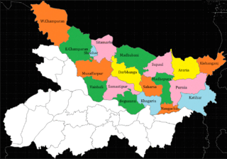
North Bihar is a term used for the region of Bihar, India, which lies north of the Ganga river.

<span class="mw-page-title-main">Barauni–Gorakhpur, Raxaul and Jainagar lines</span> Railway line in India

The Barauni–Gorakhpur, Raxaul and Jainagar lines are a set of three lines connecting Barauni in the Indian state of Bihar with Gorakhpur in Uttar Pradesh. The lines run in an east–west direction between the Ganges and India-Nepal border, covering northern Bihar west of the Kosi river and eastern Uttar Pradesh. The southernmost of the lines connects via Hajipur Junction, Sonpur Junction,Chhapra and Siwan Junction. The central line connects via Muzaffarpur, Motihari and Sugauli. The northern line connects via Darbhanga, Sitamarhi and Raxaul. The lines have interconnections between them and the northern line has extensions to places near the India–Nepal border.

The Muzaffarpur–Gorakhpur line is a set of three lines connecting Muzaffarpur in the Indian state of Bihar with Gorakhpur in Uttar Pradesh. The lines run in an east–west direction between the Gandak and India–Nepal border, covering North Bihar west of the Kosi river and eastern Uttar Pradesh. The southernmost of the three lines connects via Hajipur Junction, Sonpur Junction and Chhapra. The central line connects via Motihari and Sugauli. The northern line connects via Sitamarhi and Raxaul. The lines have interconnections between them and the northern line has extensions to places near the India–Nepal border.

Matiya is a village of Vaishali district in the Bihar state of India. It is surrounded by four district of Bihar, which are Samastipur in East, Saran in West, Muzaffarpur in North and Patna in South. The nearest city Hajipur is about 23 km and 31 km away from here. Nearest Railway Station from here is Desari in West and Sahadai Buzurg in East.

Raghopur Narsanda is a village in the Vaishali district of Bihar, India, in Patepur Block. It is 60 km from the main local city of Patna, and 40 km from its district headquarters of Hajipur. Its nearest towns are Muzaffarpur Patepur, Chehrakala, Jandaha, Samastipur Mahnar, Garaul and Tajpur.

References

  1. "Welcome to nginx!". panchayatdirectory.gov.in. Archived from the original on 28 April 2015. Retrieved 3 February 2022.
  2. "Delimitation Commission of India: Order No. 48" (PDF). Eci.nic.in. Archived (PDF) from the original on 12 July 2017. Retrieved 11 January 2018.
  3. "Census of India : List of Towns and Villages". Censusindia.gov.in. Archived from the original on 28 April 2016. Retrieved 24 April 2015.
  4. 1 2 3 4 5 6 7 8 9 "Imperial Gazetteer of India" (GIF). Dsal.uchicago.edu. Archived from the original on 4 March 2016. Retrieved 11 January 2018.
  5. 1 2 O'Malley, L. S. S. (2007). Bihar And Orissa District Gazetteers : Monghyr - L.S.S. O'malley. ISBN   9788172681357 . Retrieved 24 April 2015.
  6. "History of Bihar". Gov.bih.nic.in. Archived from the original on 31 March 2014. Retrieved 11 January 2018.
  7. "Census of India: Search Details". Censusindia.gov.in. Archived from the original on 23 March 2015. Retrieved 24 April 2015.
  8. "Climatological Information for Umaidpur". Local Resident. Archived from the original on 24 February 2015. Retrieved 11 May 2014.
  9. "National Highway 103". Indiamapped.com. Archived from the original on 12 January 2018. Retrieved 11 January 2018.
  10. "P.S. Umaidpur, Morwa". Schoolsworld.in. Archived from the original on 24 September 2015. Retrieved 24 April 2015.
  11. "List of Villages in Morwa Tehsil". Villageinfo.in. Archived from the original on 25 November 2015. Retrieved 11 January 2018.
  12. "::District Administration::". Samastipur.bih.nic.in. Archived from the original on 8 December 2017. Retrieved 11 January 2018.
  13. "Morwa Assembly Election Results 2015, Candidate List, Constituency Map". Mapsofindia.com. Archived from the original on 12 February 2018. Retrieved 11 January 2018.
  14. "Ujiarpur(Bihar) Lok Sabha Election Results 2014 with Sitting MP and Party Name". Elections.in. Archived from the original on 12 January 2018. Retrieved 11 January 2018.
Map all coordinates using: OpenStreetMap