Hooper, Colorado

Last updated

Hooper, Colorado
Town of Hooper [1]
DemonSculpureHooper.JPG
The Demon Sculpture in Hooper
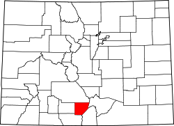
Alamosa County Colorado Incorporated and Unincorporated areas Hooper Highlighted 0837380.svg
Location of the Town of Hooper in the Alamosa County, Colorado.
Usa edcp location map.svg
Red pog.svg
Hooper
Location of the Town of Hooper in the United States.
Coordinates: 37°44′45″N105°52′37″W / 37.74583°N 105.87694°W / 37.74583; -105.87694
Country Flag of the United States.svg  United States
State Flag of Colorado.svg  Colorado
County Alamosa County
Incorporated (town) May 20, 1898 [2]
Government
  Type Statutory Town [1]
Area
[3]
  Total0.25 sq mi (0.65 km2)
  Land0.25 sq mi (0.65 km2)
  Water0.00 sq mi (0.00 km2)
Elevation
[4]
7,559 ft (2,304 m)
Population
 (2020) [5]
  Total81
  Density320/sq mi (120/km2)
Time zone UTC-7 (MST)
  Summer (DST) UTC-6 (MDT)
ZIP code [6]
81136
Area code 719
FIPS code 08-37380
GNIS feature ID2412766 [4]

The Town of Hooper is a Statutory Town located in the San Luis Valley in Alamosa County, Colorado, United States. The population was 81 at the 2020 census. [5]
Contents

Geography

According to the United States Census Bureau, the town has a total area of 0.27 square miles (0.7 km2), all of it land. [7]

Nearby points of interest include the Great Sand Dunes National Park and the town of Crestone.

History

The post office at Hooper was known as Garrison from January 26, 1891, until July 17, 1896. [8] The present name honors Major S. Hooper, a railroad official. [9] Hooper was in Costilla County, Colorado until March 8, 1913, when the formation of Alamosa County was authorized by the state legislature. [10]

Demographics

Historical population
CensusPop.Note
1900 177
1910 131−26.0%
1920 15619.1%
1930 155−0.6%
1940 1709.7%
1950 103−39.4%
1960 58−43.7%
1970 8037.9%
1980 71−11.2%
1990 11257.7%
2000 1239.8%
2010 103−16.3%
2020 81−21.4%

See also

Related Research Articles

<span class="mw-page-title-main">Costilla County, Colorado</span> County in Colorado, United States

Costilla County is a county located in the U.S. state of Colorado. As of the 2020 census, the population was 3,499. The county seat is San Luis, the oldest continuously occupied town in Colorado.

<span class="mw-page-title-main">Amherst, Colorado</span> Census-designated place in Phillips County, Colorado, United States

Amherst is a census-designated place (CDP) and a post office in and governed by Phillips County, Colorado, United States. The Amherst post office has the ZIP Code 80721. At the United States Census 2020, the population of the Amherst CDP was 47.

Arapahoe is a census-designated place (CDP) in Cheyenne County, Colorado, United States. The population was 102 at the 2020 census. The Arapahoe post office has the ZIP code 80802.

<span class="mw-page-title-main">Brandon, Colorado</span> Censuu-designated place in Kiowa County, Colorado, United States

Brandon is a census-designated place (CDP) in and governed by Kiowa County, Colorado, United States. The population of the Brandon CDP was 21 at the United States Census 2020. The Sheridan Lake post office serves Brandon postal addresses.

<span class="mw-page-title-main">Bristol, Colorado</span> Unincorporated community in Prowers County, Colorado, United States

Bristol is an unincorporated community in Prowers County, Colorado, United States. The U.S. Post Office at Holly now serves Bristol postal addresses.

<span class="mw-page-title-main">Alder, Colorado</span> Town in Colorado, United States

Alder is an extinct town located in Saguache County, Colorado, United States.

<span class="mw-page-title-main">Alice, Colorado</span> Town in Colorado, United States

Alice is an unincorporated community located in Clear Creek County, Colorado, United States.

Duncan is an extinct town in Saguache County, Colorado, about 8 miles south of Crestone, Colorado. Only one house remains, John Duncan's cabin. Duncan was on the Luis Maria Baca Grant No. 4 and is now within Rio Grande National Forest.

<span class="mw-page-title-main">Discontinued post office</span> Post office that no longer operates

A discontinued post office or DPO is an American postal term for a post office which is no longer in service or is in service under another name. Some are in ghost towns, some victims of consolidation of mail service as small post offices are closed or a city expands. The introduction of Rural Free Delivery, RFD, in 1902 led to the closure of many post offices, which peaked in 1901 at 76,945. In the United States, which was mostly rural, mail previously had been picked up in rural areas at small local post offices, home delivery being limited to urban areas until experimentation with rural delivery began in 1890.

<span class="mw-page-title-main">Fulford, Colorado</span> Census-designated place in Colorado, United States

Fulford is an extinct town and a census-designated place (CDP) located in Eagle County, Colorado, United States. The population of the Fulford CDP was 0 at the United States Census 2020. The CDP is a part of the Edwards, CO Micropolitan Statistical Area. The Fulford post office operated from February 5, 1892, until May 15, 1910. The Edwards post office now serves the area.

<span class="mw-page-title-main">Goldfield, Colorado</span> Census Designated Place in Colorado, United States

Goldfield is an unincorporated community and a census-designated place (CDP) located in and governed by Teller County, Colorado, United States. The CDP is a part of the Colorado Springs, CO Metropolitan Statistical Area. The population of the Goldfield CDP was 63 at the United States Census 2020. The Cripple Creek post office (Zip Code 80813) serves the area.

<span class="mw-page-title-main">Costilla, New Mexico</span> Census-designated place in New Mexico, United States

Costilla is a census-designated place in Taos County, New Mexico, United States. Its population was 205 as of the 2010 census. Costilla has a post office with ZIP code 87524. State roads 196 and 522 intersect in the community.

Adena is an extinct town located in Morgan County, Colorado, United States. The townsite is located at 40.0083°N 103.8866°W at an elevation of 4,692 feet (1,430 m).

Axial is an extinct coal mining town located in Moffat County, Colorado, United States.

Beshoar is an extinct town located in Las Animas County, Colorado, United States. The townsite is located at 37.2181°N 104.4066°W at an elevation of 5,922 feet (1,805 m).

<span class="mw-page-title-main">Bloom, Colorado</span> Ghost town

Bloom is an extinct town located in Otero County, Colorado, United States. The townsite is located at 37.6875°N 103.9566°W at an elevation of 4,800 feet (1,463 m).

Buckingham is an extinct town located in Weld County, Colorado, United States. The townsite is located at 40.6214°N 103.9777°W at an elevation of 4,944 feet (1,507 m).

<span class="mw-page-title-main">Delcarbon, Colorado</span> Ghost town in Huerfano County, Colorado, United States.

Delcarbon is an extinct town in Huerfano County, Colorado, United States.

<span class="mw-page-title-main">Haybro, Colorado</span>

Haybro,, is an extinct town in Routt County, Colorado, United States.

Iola is an extinct town located in Gunnison County, Colorado, United States. The community was inundated and destroyed by the creation of Blue Mesa Reservoir.

References

  1. 1 2 3 "Active Colorado Municipalities". Colorado Department of Local Affairs . Retrieved December 28, 2021.
  2. "Colorado Municipal Incorporations". State of Colorado, Department of Personnel & Administration, Colorado State Archives. December 1, 2004. Retrieved September 2, 2007.
  3. "2019 U.S. Gazetteer Files". United States Census Bureau. Retrieved July 1, 2020.
  4. 1 2 U.S. Geological Survey Geographic Names Information System: Hooper, Colorado
  5. 1 2 United States Census Bureau. "Hooper town, Colorado" . Retrieved April 2, 2023.
  6. "ZIP Code Lookup". United States Postal Service. Archived from the original (JavaScript/HTML) on November 4, 2010. Retrieved October 6, 2007.
  7. "Geographic Identifiers: 2010 Demographic Profile Data (G001): Hooper town, Colorado". U.S. Census Bureau, American Factfinder. Archived from the original on February 12, 2020. Retrieved May 3, 2013.
  8. Page 60, Bauer, William H.; Ozment, James L.; and Willard, John H., Colorado Post Offices, 1859-1989: A Comprehensive Listing of Post Offices, Stations, and Branches, Colorado Railroad Museum (May 1990), hardcover, 280 pages, ISBN   978-0-918654-42-7
  9. Dawson, John Frank. Place names in Colorado: why 700 communities were so named, 150 of Spanish or Indian origin. Denver, CO: The J. Frank Dawson Publishing Co. p. 27.
  10. Page 242, Bauer, William H.; Ozment, James L.; and Willard, John H., Colorado Post Offices, 1859-1989: A Comprehensive Listing of Post Offices, Stations, and Branches, Colorado Railroad Museum (May 1990), hardcover, 280 pages, ISBN   978-0-918654-42-7

Further reading

Melvin McAllister, Life in Hooper, Colorado, self-published (1998), 211 pages OCLC   43887168