Boulder County is one of the 64 counties of the U.S. state of Colorado of the United States. As of the 2010 census, the population was 294,567. The most populous municipality in the county and the county seat is Boulder.

The Fraser River is a tributary of the Colorado River, approximately 32.5 miles (52.3 km) long, in north central Colorado in the United States. It drains large portion of the Middle Park basin in Grand County in the Rocky Mountains west of Boulder and southwest of Rocky Mountain National Park. It rises at the continental divide on the north side of Berthoud Pass in the Arapaho National Forest. It flows NNW past Winter Park, Fraser, and Tabernash, and joins the Colorado River from the south two miles west of Granby.

Middle Park is a high basin in the Rocky Mountains of north-central Colorado in the United States. It is located in Grand County, on the southwest slope of Rocky Mountain National Park, approximately 50 miles (80 km) west of Boulder.

The Rabbit Ears Range is a mountain range of the Rocky Mountains in north central Colorado in the United States. The range stretches east-west along the continental divide forming the border between Grand and Jackson Counties, separating Middle Park (south) from North Park (north). The range connects the Front Range on the east with the Park Range and the Gore Range on the west. It is traversable at Willow Creek Pass. Muddy Pass separates the Rabbit Ears range to the east from the Park Range to the north. Rabbit Ears Pass, and Rabbit Ears Peak, despite their names, are not in the Rabbit Ears Range, but actually reside in the Park Range to the south.

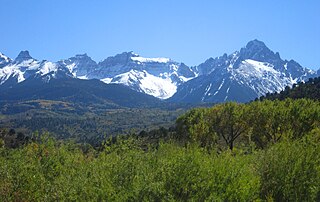
The geography of the U.S. State of Colorado is diverse, encompassing both rugged mountainous terrain, vast plains, desert lands, desert canyons, and mesas. In 1861, the United States Congress defined the boundaries of the new Territory of Colorado exclusively by lines of latitude and longitude, stretching from 37°N to 41°N latitude, and from 102°02'48"W to 109°02'48"W longitude. Starting in 1868, official surveys demarcated the boundaries, deviating from the parallels and meridians in several places. Later surveys attempted to correct some of these mistakes but in 1925 the U.S. Supreme Court affirmed that the earlier demarcation was the official boundary. The borders of Colorado are now officially defined by 697 boundary markers connected by straight boundary lines. Colorado, Wyoming, and Utah are the only states that have their borders defined solely by straight boundary lines with no natural features. The southwest corner of Colorado is the Four Corners Monument at 36°59'56"N, 109°2'43"W. This is the only place in the United States where four states meet: Colorado, New Mexico, Arizona, and Utah.

The Indian Peaks Wilderness is a wilderness area in north central Colorado managed jointly by the United States Forest Service and the National Park Service within the Arapaho and Roosevelt National Forests and small parts of the southern section of Rocky Mountain National Park. It borders the James Peak Wilderness to the south, and straddles the Continental Divide. The area receives high visitation due to its proximity to the Denver metropolitan area.

North Arapaho Peak is the highest summit of the Indian Peaks in the northern Front Range of the Rocky Mountains of North America. The 13,508-foot (4,117 m) thirteener is located in the Indian Peaks Wilderness, 7.8 miles (12.6 km) west-southwest of the Town of Ward, Colorado, United States, on the Continental Divide separating Roosevelt National Forest and Boulder County from Arapaho National Forest and Grand County.

Mount Meeker is a high mountain summit of the Twin Peaks Massif in the northern Front Range of the Rocky Mountains of North America. The 13,916-foot (4,242 m) thirteener is located in the Rocky Mountain National Park Wilderness, 4.8 miles (7.7 km) west by north of the community of Allenspark in Boulder County, Colorado, United States.
Braddock Peak is a mountain summit in the Never Summer Mountains range of the Rocky Mountains of North America. The 11,972-foot (3,649 m) peak is located in State Forest State Park, 3.0 miles (4.8 km) south-southwest of Cameron Pass in Jackson County, Colorado, United States.
Flagstaff Mountain is a foothill on the eastern flank of the Front Range of the Rocky Mountains of North America. The 6,983-foot (2,128 m) peak is located in Boulder Mountain Park in Boulder County, Colorado, United States.

The following outline is provided as an overview of and topical guide to the U.S. state of Colorado:

Mount Richthofen is the highest summit of the Never Summer Mountains range of the Rocky Mountains of North America. The prominent 12,945-foot (3,946 m) peak is located 5.6 miles (9.0 km) northwest by west of Milner Pass, Colorado, United States, on the Continental Divide separating the Rocky Mountain National Park Wilderness in Rocky Mountain National Park and Grand County from Routt National Forest and Jackson County. The mountain was named in honor of pioneering German geologist Baron Ferdinand von Richthofen, apparently by Clarence King's 1870 survey team.
Mount Alice is a high mountain summit in the northern Front Range of the Rocky Mountains of North America. The 13,315-foot (4,058 m) thirteener is located in the Rocky Mountain National Park Wilderness, 12.0 miles (19.3 km) southwest by south of the Town of Estes Park, Colorado, United States, immediately east of the Continental Divide between Boulder and Grand counties. Just who the namesake Alice was is unclear, but according to one source she was likely a "woman of ill repute".

Bear Peak is a mountain summit in the Front Range of the Rocky Mountains of North America. The 8,459-foot (2,578 m) peak is located in Boulder Mountain Park, 5.2 miles (8.3 km) south-southwest of downtown Boulder in Boulder County, Colorado, United States.

Mount Audubon is a high mountain summit of the Indian Peaks in the northern Front Range of the Rocky Mountains of North America. The 13,229-foot (4,032 m) thirteener is located in the Indian Peaks Wilderness of Roosevelt National Forest, 5.6 miles (9.0 km) west-northwest of the Town of Ward in Boulder County, Colorado, United States. The mountain was named in honor of John James Audubon.

Green Mountain is a mountain summit on the eastern flank of the Front Range of the Rocky Mountains of North America. The 8,148-foot (2,484 m) peak is located in Boulder Mountain Park, 4.2 miles (6.8 km) southwest by south of downtown Boulder in Boulder County, Colorado, United States. The mountain is renowned for the Flatirons rock formations on its eastern flank.
The Front Range Urban Corridor is an oblong region of urban population located along the eastern face of the Southern Rocky Mountains, encompassing 18 counties in the US states of Colorado and Wyoming. The corridor derives its name from the Front Range, the mountain range that defines the west central boundary of the corridor. The region comprises the northern portion of the Southern Rocky Mountain Front geographic area, which in turn comprises the southern portion of the Rocky Mountain Front geographic area of Canada and the United States. The Front Range Urban Corridor had an estimated population of 4,833,260 on July 1, 2016, an increase of +11.53% since the 2010 United States Census.