Lake Marble Falls is a reservoir on the Colorado River in the Texas Hill Country in the United States. The reservoir was formed in 1951 by the construction of Max Starcke Dam by the Lower Colorado River Authority. Originally named Marble Falls Dam, the dam was renamed in 1962 for Max Starcke, the second general director of the LCRA. Located near the town of Marble Falls, the lake is used as a venue for aquatic recreation and for the purpose of generating hydroelectric power. It is the newest and smallest of the Texas Highland Lakes.

Inks Lake is a reservoir on the Colorado River in the Texas Hill Country in the United States. The reservoir was formed in 1938 by the construction of Inks Dam by the Lower Colorado River Authority. Located near Burnet, Texas, the lake serves to provide flood control in tandem with Lake Buchanan and features the smallest hydroelectric power plant on the Highland Lakes chain. Inks Lake was named for Roy B. Inks, one of the original board members of the Lower Colorado River Authority, and serves as a venue for outdoor recreation, including fishing, boating, swimming, camping, and picnicking.

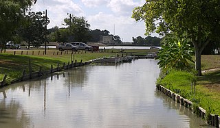
Lake McQueeney is a reservoir on the Guadalupe River located 5 miles (8 km) west of Seguin in Guadalupe County, Texas, United States. It was formed in 1928 by the construction of a dam to provide hydroelectric power to the area. Management of the dam and lake was assumed by the Guadalupe-Blanco River Authority on May 1, 1963. Its prominent feature is Treasure Island, a residential area that has been subjected to major flooding in 1972, 1998, and 2002. Most of it is approximately 10 feet (3 m) deep, with deeper sections along the center channel of the river. It is a venue for outdoor recreation, including fishing, boating, and swimming, and is maintained at a constant level year round. Amid concerns of aging dams along the lower Guadalupe River, the Guadalupe-Blanco River Authority announced that four lakes will be drained including lake McQueeny beginning Sept 16th (2019).

Curecanti National Recreation Area(Pronounced or .) is a National Park Service unit located on the Gunnison River in western Colorado. Established in 1965, Curecanti National Recreation Area is responsible for developing and managing recreational facilities on three reservoirs, Blue Mesa Reservoir, Morrow Point Reservoir and Crystal Reservoir, constructed on the upper Gunnison River in the 1960s by the U.S. Bureau of Reclamation to better utilize the vital waters of the Colorado River and its major tributaries. A popular destination for boating and fishing, Curecanti offers visitors two marinas, traditional and group campgrounds, hiking trails, boat launches, and boat-in campsites. The state's premiere lake trout and Kokanee salmon fisheries, Curecanti is a popular destination for boating and fishing, and is also a popular area for ice-fishing in the winter months.

Granger Lake is a United States Army Corps of Engineers reservoir on the San Gabriel River in central Texas in the United States. The lake is located near the towns of Granger, Texas and Taylor, Texas in Williamson County. The dam, lake, and all adjacent property are managed by the Fort Worth District of the U.S. Army Corps of Engineers. The reservoir was officially impounded in 1980, and serves to provide flood control for the communities downstream. Granger Lake is a popular recreational destination.

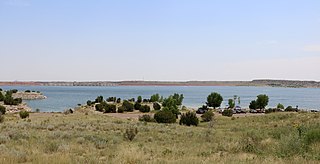
Amistad Reservoir is a reservoir on the Rio Grande at its confluence with the Devils River 12 miles (19 km) northwest of Del Rio, Texas. The lake is bounded by Val Verde County on the United States side of the international border and by the state of Coahuila on the Mexican side of the border; the American shoreline forms the Amistad National Recreation Area. The reservoir was formed in 1969 by the construction of Amistad Dam. The dam and lake are managed jointly by the governments of the United States and Mexico through the International Boundary and Water Commission. The name of the dam and lake is the Spanish word for "friendship". The reservoir is also known as Lake Amistad.

Canyon Lake is a reservoir on the Guadalupe River in the Texas Hill Country in the United States. Canyon Lake is a U.S. Army Corps of Engineers reservoir formed on the Guadalupe River in Comal County by Canyon Dam, which is located about sixteen miles northwest of New Braunfels. The dam, lake, and all adjacent property are managed by the U.S. Army Corps Of Engineers. Water rights, waste water treatment, and hydroelectric generating facilities are managed by the Guadalupe-Blanco River Authority. Construction of the dam began in 1958 and was completed in 1964. The reservoir serves to provide flood control and water supply for the communities downstream from the dam. The lake is also a popular recreational destination.
Lake Wood was a reservoir on the Guadalupe River 4 miles (6 km) west of the town of Gonzales in Gonzales County, Texas. The reservoir was formed in 1931 by the construction of a dam to provide hydroelectric power to the area. Management of the dam and lake was assumed by the Guadalupe-Blanco River Authority on May 1, 1963. Lake Wood served as a venue for outdoor recreation, including fishing and boating.
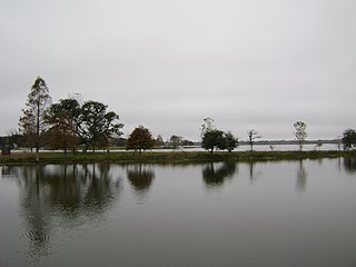
Coleto Creek Reservoir is a reservoir on Coleto Creek and Perdido Creek located in Fannin, Texas, 15 miles (24 km) southwest of Victoria, Texas. The surface of the lake extends into Victoria and Goliad counties. The reservoir was formed in 1980 by the construction of a dam by the Guadalupe-Blanco River Authority to provide a power station cooling pond for electric power generation. Coleto Creek Reservoir is a venue for outdoor recreation, including fishing and boating.

The Cochiti Dam is an earthen fill dam located on the Rio Grande in Sandoval County, New Mexico, approximately 50 miles (80 km) north of Albuquerque, New Mexico, in the United States. By volume of material, it is the 23rd largest dam in the world at 62,849,000 yd3 of material, one of the ten largest such dams in the United States, and the eleventh largest such dam in the world. Cochiti Dam is one of the four United States Army Corps of Engineers projects for flood and sediment control on the Rio Grande system, operating in conjunction with Abiquiu Dam, Galisteo Dam and Jemez Canyon Dam.

Bonny Lake State Park is a former state park located in Yuma County, Colorado near Hale. Created in 1966 and closed in 2011, Bonny Lake was the easternmost state park in Colorado.
Lake Pueblo State Park is a state park located in Pueblo County, Colorado. It includes 60 miles (97 km) of shoreline and 10,000 acres (40 km2) of land. Activities it offers include two full-service marinas, recreational fishing, hiking, camping and swimming at a special swim beach.

Vega State Park is a 1,823-acre (738 ha) Colorado state park in Mesa County, Colorado in the United States. Vega Reservoir is a fishing destination and is located at an elevation of 7,696 feet (2,346 m). Year-round recreational activities at Vega State Park include boating, hiking, snowmobiling and camping. The park was established in 1967 in cooperation with the Bureau of Reclamation which was responsible for the construction of Vega Dam and Vega Reservoir.

Staunton State Park is a Colorado state park in Park and Jefferson counties, located 6 miles (9.7 km) west of Conifer, Colorado. The 3,908-acre (1,582 ha) park, which opened on May 18, 2013, includes dramatic rock outcroppings, several streams and a waterfall. On December 4, 2012, the property was also listed on the National Register of Historic Places as Staunton Ranch-Rural Historic Landscape.

San Angelo State Park is a Texas state park in San Angelo, Texas in the United States. It encompasses 7,677 acres (3,107 ha) leased by Texas Parks and Wildlife Department from the United States Army Corps of Engineers. It opened in 1995 and is located on the shores of the O.C. Fisher Reservoir.
Navajo State Park is a state park of Colorado, USA, on the north shore of Navajo Lake. Touted as Colorado's answer to Lake Powell, this reservoir on the San Juan River begins in Colorado's San Juan Mountains and extends 20 miles (32 km) into New Mexico. Its area is 15,000 acres (6,100 ha), and it has 150 miles (240 km) of shoreline in two states. Park activities include boating, houseboating, fishing, camping, and wildlife viewing. There is a New Mexico state park at the southern end of the lake.

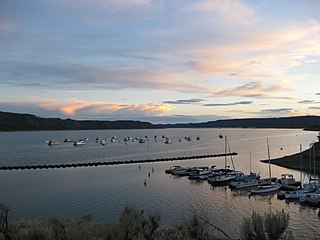
Elkhead Reservoir State Park is a Colorado state park located in Moffat and Routt counties in northwest Colorado, near Craig. The park surrounds and includes the 900 surface acre Elkhead Reservoir. It is referred to as Elkhead State Park. Elkhead Reservoir State Park is managed as a complex out of the Yampa River State Park office, located to the west of the town of Hayden, CO.
Colorow Mountain is a summit in the Indian Valley area in Rio Blanco County, Colorado. The Colorow Mountain State Wildlife Area is located on the mountain.

Lake Avery is a reservoir in Rio Blanco County, Colorado about 20 miles southeast of the town of Meeker. The reservoir is owned by Colorado Parks and Wildlife, and its dam impounds Big Beaver Creek, a tributary of the White River. Lake Avery is also called Big Beaver Reservoir, but it is unclear whether the name has changed or whether the reservoir just has two names.