While similar to a peninsula in shape, a salient is most often not surrounded by water on three sides. Instead, it has a land border on at least two sides and extends from the larger geographical body of the administrative unit.
In American English, the term panhandle is often used to describe a relatively long and narrow salient, such as the westernmost extensions of Florida and Oklahoma, or the northernmost portion of Idaho. Another term is bootheel, used for the Missouri Bootheel and New Mexico Bootheel areas.
Origin
The term salient is derived from military salients. The term "panhandle" derives from the analogous part of a cooking pan, and its use is generally confined to North America.
The salient shape can be the result of arbitrarily drawn international or subnational boundaries, which serve to separate culturally unified peoples.[1] These occurred, for instance, during European colonialisation when colonial powers competed for Africa and the Western Hemisphere, after which post-colonial borders became based on colonial divisions.[2] In many cases these salients correspond to routes of expansion or bases for such expansion, as in Namibia and Mozambique.[3] Other modern salients originally served to provide barriers against other colonial powers, as with Britain against Tsarist Russia in Central Asia.[1]
Salients may also arise when a national government shifts territory between subnational entities for internal political reasons, as with West Virginia's eastern panhandle during the Civil War.[4] This also occurred with peripheral Tibetan-inhabited regions in Maoist China, which were split between provinces and from the Tibet Autonomous Region.[5]
The location of administrative borders can also take into account other considerations such as economic ties,[6] strategic needs,[7] history or topography. Even in these situations, however, salients frequently fail to follow clear and logical criteria, as seen with the partition of India and the resultant northeastern salient. Upon partition numerous majority-Muslim areas remained within Hindu India, and some non-Muslim-majority areas within the exclave of East Pakistan.[8]
Country-level salients
Africa
Far North Province of CameroonA map of the Congo Pedicle
Chittagong Division, BangladeshMap of India showing the Seven Sister states in the northeast plus the smaller salient of Sikkim immediately to their west.The 14 provinces of Thailand forming the salient of Southern Thailand.
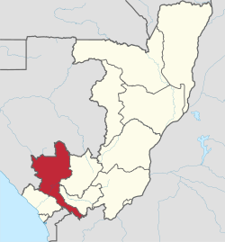
Location of Niari Department within the Republic of the Congo. The southeastern arm is the Kimongo District.Location of the Fatick Region within Senegal. Gossas Department is the northeastern arm.
Guayas Province, Ecuador. Balzar and El Empalme Cantons form the northern arm of the province.Venezuela's Barinas State. Andrés Eloy Blanco is the small western extension of the state, Arismendi is the larger eastern extremity. Páez, in Apure, lies immediately to the south of western Barinas.
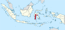
Location of Nabatieh District within Nabatieh Governorate, Lebanon.Map of Gorno-Badakhshan within Tajikistan, showing the panhandle of Darvoz District in the west.South Sulawesi in Indonesia, with a panhandle of East Luwu Regency in the east
Location of Viken, Norway. The municipalities of Jevnaker and Lunner connect the former counties of Akershus and BuskerudLocation of Newmarket (shown as red dot) within Suffolk, EnglandLocation of Manche within Normandy, France
Location of Anetan District within NauruLocation of Timaru District within New Zealand's South Island. The Waitaki District is parallel with it, a little further south.
↑Lowitt, Richard (2006). American Outback: The Oklahoma Panhandle in the Twentieth Century. Texas Tech University Press. pp.xvii, xviii. ISBN9780896725584.
↑Weigert, Hans W. (1957). Principles of Political Geography. New York City: Appleton-Century-Crofts. pp.73–75.
↑Hubbard, Bill (2008). "Chapter Five: The Evolution of the Territories and States". American Boundaries: The Nation, the States, the Rectangular Survey. University of Chicago Press. p.167. ISBN9780226355931.
↑Sautman, Barry (2006). "Tibet and the (Mis)-Representation of Cultural Genocide". In Sautman, Barry (ed.). Cultural Genocide and Asian State Peripheries. New York City: Palgrave Macmillan. p.207. ISBN1403975744.
This page is based on this Wikipedia article Text is available under the CC BY-SA 4.0 license; additional terms may apply. Images, videos and audio are available under their respective licenses.