Related Research Articles

Granville is a suburb in western Sydney, in the state of New South Wales, Australia. Granville is located 18 kilometres (11 mi) west of the Sydney central business district, split between the local government areas of Cumberland City Council and the City of Parramatta.

The Parramatta River is an intermediate tide-dominated, drowned valley estuary located in Sydney, New South Wales, Australia. With an average depth of 5.1 metres (17 ft), the Parramatta River is the main tributary of Sydney Harbour, a branch of Port Jackson. Secondary tributaries include the smaller Lane Cove and Duck rivers.

The Inner West of Sydney is an area directly west of the Sydney central business district, New South Wales, Australia. The suburbs that make up the Inner West are predominantly located along the southern shore of Port Jackson, stretching south to the shores of the Cooks River. The western boundary of the Inner West is approximately the A3 arterial road, which divides the Inner West from the Greater Western Sydney region. The Inner West is much larger than the Inner West Council local government area. The Inner West roughly corresponds with the Parish of Petersham and Parish of Concord, two cadastral divisions used for land titles.

Greater Western Sydney (GWS) is a large region of the metropolitan area of Greater Sydney, New South Wales, Australia that generally embraces the north-west, south-west, central-west, and far western sub-regions within Sydney's metropolitan area and encompasses 13 local government areas: Blacktown, Canterbury-Bankstown, Camden, Campbelltown, Cumberland, Fairfield, Hawkesbury, Hills Shire, Liverpool, Parramatta, Penrith, Wollondilly and the western portion of the City of Parramatta Council. It includes Western Sydney, which has a number of different definitions, although the one consistently used is the region composed of ten local government authorities, most which are members of the Western Sydney Regional Organisation of Councils (WSROC). Penrith, Hills Shire & Canterbury-Bankstown are not WSROC members. The NSW Government's Office of Western Sydney uses the broader Greater Western Sydney definition to refer to the region.

The Division of Parramatta is an Australian electoral division in the state of New South Wales. The division was created in 1900 and was one of the original 65 divisions contested at the first federal election. It is named for the locality of Parramatta. The name Parramatta has been sourced to an Aboriginal word for the area. The Darug people had lived in the area for many generations, and regarded the area as a food bowl, rich in food from the river and forests. They called the area Baramada or Burramatta ('Parramatta') which means "the place where the eels lie down".
Holroyd is a small suburb in western Sydney, New South Wales, Australia. Holroyd is located 20 kilometres (12 mi) west of the Sydney central business district in the local government area of the Cumberland Council. The local government area takes its name from Arthur Holroyd, first Mayor of the area, local landowner and businessman. The administrative centre is located in nearby Merrylands.

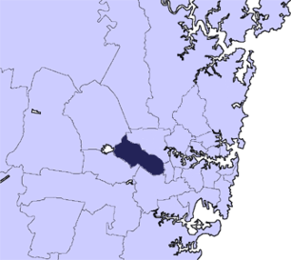
The City of Parramatta Council is a local government area located west of central Sydney in the Greater Western Sydney region. Parramatta Council is situated between the City of Ryde and Cumberland, where the Cumberland Plain meets the Hornsby Plateau, approximately 25 kilometres (16 mi) west of the Sydney central business district, in the state of New South Wales, Australia.

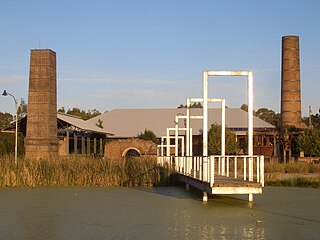
Camellia is a post industrial suburb of Sydney, in the state of New South Wales, Australia. It began brownfields remediation in late 2015, and is ear-marked as a major centre for high density living.

Prospect Creek, an urban watercourse of the Georges River catchment, is located in the western and Canterbury-Bankstown regions of Sydney, in New South Wales, Australia.
Cabramatta Creek, an urban watercourse of the Georges River catchment, is located in the south-western region of Sydney, in New South Wales, Australia.

The geography of Sydney is characterised by its coastal location on a basin bordered by the Pacific Ocean to the east, the Blue Mountains to the west, the Hawkesbury River to the north and the Woronora Plateau to the south. Sydney lies on a submergent coastline on the east coast of New South Wales, where the ocean level has risen to flood deep river valleys (rias) carved in the Sydney sandstone. Port Jackson, better known as Sydney Harbour, is one such ria.

The Cumberland Plain, an IBRA biogeographic region, is a relatively flat region lying to the west of Sydney CBD in New South Wales, Australia. Cumberland Basin is the preferred physiographic and geological term for the low-lying plain of the Permian-Triassic Sydney Basin found between Sydney and the Blue Mountains, and it is a structural sub-basin of the Sydney Basin.

Haslams Creek, a southern tributary of the Parramatta River, is a creek west of Sydney Harbour, located in Sydney, Australia. It flows through Sydney Olympic Park and joins Parramatta River at Homebush Bay.
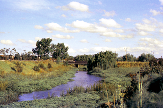
The Duck River is a perennial stream and southern tributary of the Parramatta River, in Sydney, New South Wales, Australia.

Duck Creek is a perennial stream and a southern tributary of A'Becketts Creek and part of the Parramatta River catchment, in Sydney, New South Wales, Australia.

The Darling Mills Creek, an urban watercourse that is part of the Parramatta River catchment, is located in Greater Western Sydney, New South Wales, Australia.
Terrys Creek, an urban watercourse that is part of the Lane Cove River catchment, is located in Northern Suburbs region of Sydney, Australia. It was named after Edward Terry who served as the first mayor of Eastwood municipality.
The Cumberland City Council is a local government area located in the western suburbs of Sydney in the state of New South Wales, Australia. The Council was formed on 12 May 2016 from the merger of parts of the Cities of Auburn, Parramatta, and Holroyd.
The M4 cycleway is a 15-kilometre-long (9.3 mi) shared use path for cyclists and pedestrians that is generally aligned with the M4 Motorway in Sydney, New South Wales, Australia. The eastern terminus of the cycleway is in the Sydney Olympic Park, while the western terminus is in South Wentworthville.
The Parramatta Valley cycleway is a 15-kilometre-long (9.3 mi) shared use path for cyclists and pedestrians that is generally aligned with the Parramatta River in Sydney, New South Wales, Australia. The eastern terminus of the cycleway is at Morrison Bay Park in Ryde and heads west along dedicated bike paths, quiet streets and the river foreshore to its western terminus in the Parramatta Park in Parramatta.
References
- ↑ "A'Becketts Creek". Geographical Names Register (GNR) of NSW. Geographical Names Board of New South Wales . Retrieved 9 April 2013.

- ↑ "Harris Park" (PDF). Parramatta Development Control Plan 2011. Parrmatta City Council. 2011. p. 172. Archived from the original (PDF) on 24 March 2012. Retrieved 2 September 2012.
- ↑ "Current area: Granville - Clyde". Assumptions: Residential development. Parrmatta City Council. 12 March 2009. Archived from the original on 30 December 2012. Retrieved 2 September 2012.
- ↑ "Harris Park" (PDF). Parramatta Development Control Plan 2011. Parrmatta City Council. 2011. p. 223. Archived from the original (PDF) on 24 March 2012. Retrieved 2 September 2012.
- ↑ "MAN ON MURDER CHARGE". The Sydney Morning Herald (NSW : 1842 - 1954) . National Library of Australia. 17 April 1943. p. 9. Retrieved 28 October 2012.