
Thodupuzha is a municipality and Taluka in the Idukki district of Kerala, India. It is located 55 km (34.2 mi) west of the district headquarters in Painavu and about 192 km (119.3 mi) north of the state capital Thiruvananthapuram. As per the 2011 Indian census, Thodupuzha has a population of 52,045 people, and a population density of 1,468/km2 (3,800/sq mi).

Marayur or Marayoor is a town in Devikulam taluk of Idukki district in the southwestern Indian state of Kerala. It is located 42 kilometers north of Munnar on SH 17 connecting Munnar with Udumalpet, Tamil Nadu. Marayur is situated at around 990 metres above mean sea level and is the only place in Kerala that has natural sandalwood forests. Ancient dolmens and rock paintings in Marayur date back to the Stone Age. In 1991 Marayur had a population of 9,590.

Cheruthoni is a town on the banks of Cheruthoni River, a major tributary of the Periyar River, the second longest river in Kerala state, in southwestern India. The area is known by Cheruthoni Dam, which is a part of Idukki reservoir, which provide hydroelectric power to the region.
Manakkad is a village in Thodupuzha Taluk of Idukki District in Kerala, India, bordering Thodupuzha town on the banks of the Thodupuzha river.

Devikulam is a Grama Panchayat and small hill station about 8 kilometres (5.0 mi) away from Munnar in the Idukki District of Kerala, India. It lies about 1,800 metres (5,900 ft) above sea level.

Kumily, also spelt as Kumaly is a revenue village and Gram Panchayat in the Idukki district of the state of Kerala. It is a town in Cardamom Hills near Thekkady and Periyar Tiger Reserve. Kumily is a gateway town into Kerala from Tamil Nadu.
Udumbanchola is a taluk in Idukki district of the Indian state of Kerala. This is in the high ranges. Nedumkandam is the major town and capital of Udumbanchola taluk. Mathikettan Shola National Park is located in Udumbanchola.

Kuttampuzha is a village and gram panchayat in Ernakulam district in the Indian state of Kerala. Situated 71 km east of Kochi, Kuttampuzha panchayat is home to the 17.7% of total area of the Ernakulam District.
Chakkupallam is a Grama Panchayat and Village in Idukki district in the Indian state of Kerala. The administrative capital(Panchayat Office) and village center of Chakkupallam Grama Panchayat is Anakkara, located on Kumily-Munnar state highway.

Chathurangapara is a village in Idukki district in the Indian state of Kerala. The village is part of Udumbanchola and Senapathy Panchayats.
Konnathady is a gram panchayat village in Idukki district in the Indian state of Kerala. It is situated 14 km south of National Highway 49, just south of the Mullayar River.
Mankulam is a village in Idukki district in the Indian state of Kerala. This is the first Grama Panchayat in Kerala which produces electricity on its own. It sells it to the Electricity board of Kerala.
Melukavu (Melukavumattom) is a village in the eastern part of Meenachil Taluk in Kottayam District of Kerala state, India.

Muttom is a rural area in Idukki district in the Indian state of Kerala. This place is 8.5 km away from Thodupuzha and 66 km away from Kochi. Geographically this place is part of Midland or Idanad region of Kerala.
Idukki District has four types of administrative hierarchies:

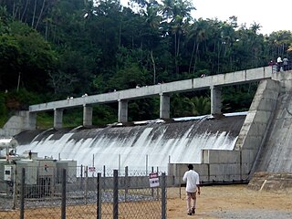
The Lower Periyar Dam is a dam built on the Periyar River as part of the Lower Periyar Hydroelectric Project in Kanjikuzhi Panchayat, Idukki District, Kerala. The dam was built to generate electricity. The lower Periyar dam is at Pambla, five kilometres downstream from where Muthirapuzha merges with main river. This 32.36-metre-high dam made of concrete has a width of 284 meters. The powerhouse is at Karimanal, near Neriamangalam, where three generators are installed with a power production capacity of 60 MW each, or a cumulative 180 MW. The Dam was completed in the year 1998 Taluks through which release flow are Idukki, Kothamangalam, Muvattupuzha, Kunnathunadu, Aluva, Kodungalloor and Paravur.

Anayirangal Dam (Malayalam: ആനയിറങ്കൽ അണക്കെട്ട്) is an earthen dam built on the Panniyar river in Chinnakanal and Santhanpara panchayats, 22 km (14 mi) from Munnar in Idukki district of Kerala, India. The dam is surrounded on one side by forest and on the other by Tata Tea Plantation. The dam is located near the Munnar - Kumily road. The water flowing from the dam reaches Kuthungal and Ponmudi dams through the Panniyar river. Power is generated at Kuthungal and Panniyar powerhouses. The dam stores water from small streams flowing from Bealram and rainwater flowing from the hills on the Tamil Nadu border. The height of the dam is 34.14 metres (112.0 ft) and Length is 326.13 metres (1,070.0 ft). The reservoir usually fills up in June and July.

Kallar Dam is a small, diversion dam constructed at Perinjamkutty river in Nedumkandam grama panchayat of Idukki district, Kerala, India. It acts mainly as a diversion dam to supply water to the Idukki dam.
Vellathooval Dam is a diversion dam built on the Muthirappuzha river in Vellathooval village in Devikulam taluk of Idukki district in Kerala, India. The height of the dam from the deepest foundation is 16 metres (52 ft) and length is 75 metres (246 ft). Water from the Sengulam Power House and from the Muthirapuzha river gets released to the Vellathooval dam. Water from this dam is diverted through a canal system to the powerhouse near Panniyar After the water flow is used to generate hydroelectricity, the water is released back into the river. The dam is one of the major tourist attractions in the Idukki District, Kerala.
