Lord Howe Island Marine Park is the site of Australia's and the world's most southern coral reef ecosystem. The island is 10 km in length, 2 km wide and consists of a large lagoonal reef system along its leeward side, with 28 small islets along its coast. In 1999, the waters within three nautical miles of Lord Howe Island (465.45 km2) were declared a marine park under the NSW Marine Park Act 1997 to protect its unique marine biodiversity, with the park currently being managed by the New South Wales Marine Parks Authority. Both Lord Howe Island and Balls Pyramid are incorporated within the three nautical miles protected by the state marine park. Both marine parks complement the island's status as a World Heritage Site.

A marine reserve is a type of marine protected area (MPA). An MPA is a section of the ocean where a government has placed limits on human activity. A marine reserve is a marine protected area in which removing or destroying natural or cultural resources is prohibited, marine reserves may also be "no-take MPAs,” which strictly forbid all extractive activities, such as fishing and kelp harvesting. As of 2007 less than 1% of the world's oceans had been set aside in marine reserves. Benefits include increases in the diversity, density, biomass, body size and reproductive potential of fishery and other species within their boundaries.

One of the first shark species to be protected was the grey nurse shark. The biology, distribution and conservation of this species are dealt with in the following paragraphs with a main focus on Australia as it was here it first became protected.

Pescador Island is a small limestone island located in the Tañon Strait, a few kilometres from the western coast of the island of Cebu in the Philippines. It is under the jurisdiction of the municipality of Moalboal.

The environmental impact of fishing includes issues such as the availability of fish, overfishing, fisheries, and fisheries management; as well as the impact of industrial fishing on other elements of the environment, such as bycatch. These issues are part of marine conservation, and are addressed in fisheries science programs. According to a 2019 FAO report, global production of fish, crustaceans, molluscs and other aquatic animals has continued to grow and reached 172.6 million tonnes in 2017, with an increase of 4.1 percent compared with 2016. There is a growing gap between the supply of fish and demand, due in part to world population growth.

Reef Check is an international non-governmental organization dedicated to the conservation of two reef ecosystems: tropical coral reefs and Californian rocky reefs. The Foundation is headquartered in Los Angeles, California, United States, but uses data from volunteer scuba diver teams in over 80 countries, ranging from Australia, Japan, to even Germany. It is the United Nations’ official coral reef monitoring program.

The Coral Triangle (CT) is a roughly triangular area in the tropical waters around the Philippines, Indonesia, Malaysia, Papua New Guinea, the Solomon Islands and Timor-Leste. This area contains at least 500 species of reef-building corals in each ecoregion. The Coral Triangle is located between the Pacific and Indian oceans and encompasses portions of two biogeographic regions: the Indonesian-Philippines Region, and the Far Southwestern Pacific Region. As one of eight major coral reef zones in the world, the Coral Triangle is recognized as a global centre of marine biodiversity and a global priority for conservation. Its biological resources make it a global hotspot of marine biodiversity. Known as the "Amazon of the seas", it covers 5.7 million square kilometres (2,200,000 sq mi) of ocean waters. It contains more than 76% of the world's shallow-water reef-building coral species, 37% of its reef fish species, 50% of its razor clam species, six out of seven of the world's sea turtle species, and the world's largest mangrove forest. In 2014, the Asian Development Bank (ADB) reported that the gross domestic product of the marine ecosystem in the Coral Triangle is roughly $1.2 trillion per year and provides food to over 120 million people. According to the Coral Triangle Knowledge Network, the region annually brings in about $3 billion in foreign exchange income from fisheries exports, and another $3 billion from coastal tourism revenues.
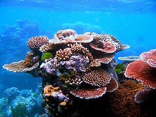
Coral reef protection is the process of modifying human activities to avoid damage to healthy coral reefs and to help damaged reefs recover. The key strategies used in reef protection include defining measurable goals and introducing active management and community involvement to reduce stressors that damage reef health. One management technique is to create Marine Protected Areas (MPAs) that directly limit human activities such as fishing.
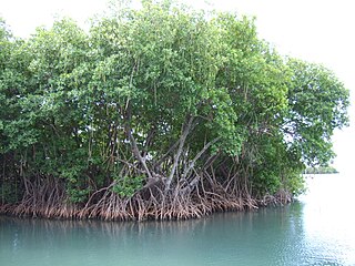
Mangrove ecosystems represent natural capital capable of producing a wide range of goods and services for coastal environments and communities and society as a whole. Some of these outputs, such as timber, are freely exchanged in formal markets. Value is determined in these markets through exchange and quantified in terms of price. Mangroves are important for aquatic life and home for many species of fish.
Blue Ventures is a registered charity focused on nurturing locally led marine conservation. The organisation partners with coastal communities that depend on marine resources.

Pom Pom Island is a small coral reef island in the Celebes Sea approximately 30 kilometres north east of Semporna town, Sabah, East Malaysia.

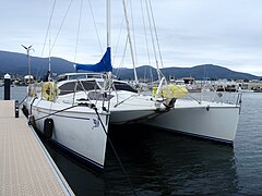
Recreational dive sites are specific places that recreational scuba divers go to enjoy the underwater environment or for training purposes. They include technical diving sites beyond the range generally accepted for recreational diving. In this context all diving done for recreational purposes is included. Professional diving tends to be done where the job is, and with the exception of diver training and leading groups of recreational divers, does not generally occur at specific sites chosen for their easy access, pleasant conditions or interesting features.
The Bathurst Channel is a narrow offshore stretch of water that links Port Davey with Bathurst Harbour in the South West region of Tasmania, Australia. The Bathurst Channel is contained within the Port Davey/Bathurst Harbour Marine Nature Reserve, and the Southwest National Park, part of the Tasmanian Wilderness World Heritage Area.
Cape Byron Marine Park is one of four marine parks in New South Wales, Australia, and is the most recently sanctioned. The Cape Byron Marine Park is located in Northern NSW and extends 37 kilometres (23 mi) from the Brunswick River to Lennox Head. The marine park extends out to 3 nautical miles which dictates the border between state and federal jurisdiction. The marine park covers an area of 220 square kilometres (85 sq mi) and includes a variety of marine terrain including beaches, rocky shores, open ocean and the tidal waters of the Brunswick River and its tributaries, the Belongil Creek and Tallow Creek. The Cape Byron Marine Park was declared in 2002 and the zoning plan was implemented in April 2006. Of the 15 distinct marine ecosystems identified within the Tweed-Moreton bioregion, the Cape Byron Marine Park supports 10 of these.
St. Crispin's Reef is an elongate outer-shelf coral reef in the Great Barrier Reef, Queensland, Australia.

The Great Southern Reef is a system of interconnected reefs that spans the southern coast of continental Australia and Tasmania and extends as far north as Brisbane to the east and Kalbarri to the west. It covers 71,000 km2 (27,000 sq mi) of ocean and straddles five states, running along the coast for 8,000 km (5,000 mi).

Gretta T. Pecl is an Australian marine ecologist, Australian Research Council Future Fellow, and the Director of the Centre for Marine Socioecology (CMS) at the University of Tasmania. Her work focuses on species and ecosystem responses to climate change, as well as using socioecological approaches to adapt natural resource management for climate change. She is on the editorial board of Springer Nature's Reviews in Fish Biology and Fisheries, and is a Subject Editor for Ecography.
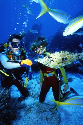
The environmental impact of recreational diving is the effects of recreational scuba diving on the underwater environment, which is largely the effects of diving tourism on the marine environment. It is not uncommon for highly trafficked dive destinations to have more adverse effects with visible signs of diving's negative impacts due in large part to divers who have not been trained to sufficient competence in the skills required for the local environment, an inadequate pre-dive orientation, or lack of a basic understanding of biodiversity and the delicate balance of aquatic ecosystems. There may also be indirect positive effects as the environment is recognised by the local communities to be worth more in good condition than degraded by inappropriate use, and conservation efforts get support from dive communities who promote environmental awareness, and teach low impact diving and the importance of respecting marine life. There are also global coral reef monitoring networks in place which include local volunteer divers assisting in the collection of data for scientific monitoring of coral reef systems, which may eventually have a net positive impact on the environment.

The red handfish is a species of handfish in the genus Thymichthys, found in Frederick Henry Bay, Tasmania.
An underwater survey is a survey performed in an underwater environment or conducted remotely on an underwater object or region. Survey can have several meanings. The word originates in Medieval Latin with meanings of looking over and detailed study of a subject. One meaning is the accurate measurement of a geographical region, usually with the intention of plotting the positions of features as a scale map of the region. This meaning is often used in scientific contexts, and also in civil engineering and mineral extraction. Another meaning, often used in a civil, structural, or marine engineering context, is the inspection of a structure or vessel to compare actual condition with the specified nominal condition, usually with the purpose of reporting on the actual condition and compliance with, or deviations from, the nominal condition, for quality control, damage assessment, valuation, insurance, maintenance, and similar purposes. In other contexts it can mean inspection of a region to establish presence and distribution of specified content, such as living organisms, either to establish a baseline, or to compare with a baseline.