Related Research Articles

A cave or cavern is a natural void in the ground, specifically a space large enough for a human to enter. Caves often form by the weathering of rock and often extend deep underground. The word cave can refer to smaller openings such as sea caves, rock shelters, and grottos, that extend a relatively short distance into the rock and they are called exogene caves. Caves which extend further underground than the opening is wide are called endogene caves.

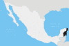
Quintana Roo, officially the Free and Sovereign State of Quintana Roo, is one of the 31 states which, with Mexico City, constitute the 32 federal entities of Mexico. It is divided into 11 municipalities and its capital city is Chetumal.

Cozumel is an island and municipality in the Caribbean Sea off the eastern coast of Mexico's Yucatán Peninsula, opposite Playa del Carmen. It is separated from the mainland by the Cozumel Channel and is close to the Yucatán Channel. The municipality is part of the state of Quintana Roo, Mexico.
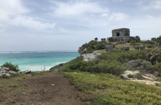
Tulum is the site of a pre-Columbian Mayan walled city which served as a major port for Coba, in the Mexican state of Quintana Roo. The ruins are situated on 12-meter-tall (39 ft) cliffs along the east coast of the Yucatán Peninsula on the Caribbean Sea. Tulum was one of the last cities built and inhabited by the Maya and achieved its greatest prominence between the 13th and 15th centuries. Maya continued to occupy Tulum for about 70 years after the Spanish began occupying Mexico, but the city was abandoned by the end of the 16th century. Tulum is one of the best-preserved coastal Maya sites, and today a popular site for tourists.

The Riviera Maya is a tourism and resort district south of Cancun, Mexico. It straddles the coastal Federal Highway 307, along the Caribbean coastline of the state of Quintana Roo, located in the eastern portion of the Yucatán Peninsula. Historically, this district started at the city of Playa del Carmen and ended at the village of Tulum, although the towns of Puerto Morelos, situated to the north of Playa del Carmen, as well as the town of Felipe Carrillo Puerto, situated 40 km (25 mi) to the south of Tulum, are both currently being promoted as part of the Riviera Maya tourist corridor.

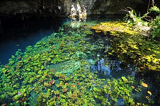
A cenote is a natural pit, or sinkhole, resulting from the collapse of limestone bedrock that exposes groundwater. The regional term is specifically associated with the Yucatán Peninsula of Mexico, where cenotes were commonly used for water supplies by the ancient Maya, and occasionally for sacrificial offerings. The term derives from a word used by the lowland Yucatec Maya—tsʼonot—to refer to any location with accessible groundwater.
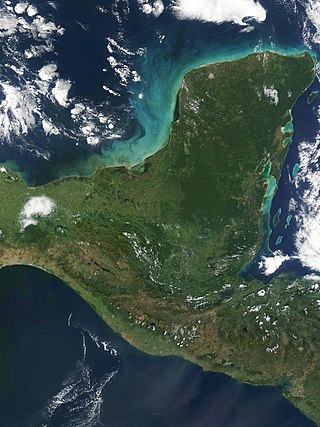
The Yucatán Peninsula is a large peninsula in southeast Mexico and adjacent portions of Belize and Guatemala. The peninsula extends towards the northeast, separating the Gulf of Mexico to the north and west of the peninsula from the Caribbean Sea to the east. The Yucatán Channel, between the northeastern corner of the peninsula and Cuba, connects the two bodies of water.

Dos Ojos is part of a flooded cave system located north of Tulum, on the Caribbean coast of the Yucatán Peninsula, in the state of Quintana Roo, Mexico. The exploration of Dos Ojos began in 1987 and still continues. The surveyed extent of the cave system is 82 kilometers (51 mi) and there are 28 known sinkhole entrances, which are locally called cenotes. In January 2018, a connection was found between Sistema Dos Ojos and Sistema Sac Actun. The smaller Dos Ojos became a part of Sac Actun, making the Sistema Sac Actun the longest known underwater cave system in the world.
Sistema Nohoch Nah Chich, is located 16.5 kilometers (10.3 mi) south of Akumal in Tulum Municipality of Quintana Roo state, southeastern Mexico. It is part of the Sistema Sac Actun underwater cave systems.
Sistema Ox Bel Ha is a cave system in Quintana Roo, Mexico. It is the 2nd longest explored underwater cave in the world and ranks fourth including dry caves. As of January 2022 the surveyed length is 319.5 kilometers (198.5 mi) of underwater passages. There are more than 140 cenotes in the system.
Sistema Sac Actun is an underwater cave system situated along the Caribbean coast of the Yucatán Peninsula with passages to the north and west of the city of Tulum. Discovery of a connection to the Sistema Dos Ojos in 2018 made it the longest known underwater cave system.
QRSS may refer to:

Eve of Naharon is the skeleton of a 20– to 25-year-old human female found in the Naharon section of the underwater cave Sistema Naranjal in Mexico near the town of Tulum, around 80 miles (130 km) south west of Cancún. The Naranjal subsystem is a part of the larger Sistema Ox Bel Ha. The skeleton is carbon dated to 13,600 years ago, which makes it one of the oldest documented human finds in the Americas.
Chan Hol, part of the Toh ha cave system, is a cenote and submerged cave system in Quintana Roo, Mexico, of interest to paleoanthropologists. The remains of three prehistoric human fossils were discovered within the cave system. Along with Eve of Naharon, Naia, the Man of El Templo and the Woman of Las Palmas, the three fossils at Chan Hol are among several ancient Paleoamerican skeletons found in the submerged cave systems of the Yucatán Peninsula around Tulum, Quintana Roo.

Hells Bells are hollow bell- or cone-shaped structures of carbonate that can reach lengths of 2 metres. They are found underwater in El Zapote cenote in Quintana Roo, Mexico, on the Yucatan Peninsula; similar formations exist in other caves. In a certain depth range, such structures cover the entire surface of the cave including submerged tree trunks and other Hells Bells, although they never touch each other.

Cave diving is underwater diving in water-filled caves. The equipment used varies depending on the circumstances, and ranges from breath hold to surface supplied, but almost all cave diving is done using scuba equipment, often in specialised configurations with redundancies such as sidemount or backmounted twinset. Recreational cave diving is generally considered to be a type of technical diving due to the lack of a free surface during large parts of the dive, and often involves planned decompression stops. A distinction is made by recreational diver training agencies between cave diving and cavern diving, where cavern diving is deemed to be diving in those parts of a cave where the exit to open water can be seen by natural light. An arbitrary distance limit to the open water surface may also be specified. Despite the risks, water-filled caves attract scuba divers, cavers, and speleologists due to their often unexplored nature, and present divers with a technical diving challenge.
Underwater exploration is the exploration of any underwater environment. Exploration is the process of exploring, which has been defined as :
References
- 1 2 "Survey and Cartography of The Underwater Caves of Quintana Roo Mexico". The National Speleological Society, Quintana Roo Speleological Survey. February 5, 2011. Retrieved February 20, 2011.
Chetumal (capital) | |||||||||||
| Municipalities (seats) |
|  | |||||||||
| Places of interest |
| ||||||||||
| | This article about a location in the Mexican state of Quintana Roo is a stub. You can help Wikipedia by expanding it. |
| | This caving-related article is a stub. You can help Wikipedia by expanding it. |