South Central United States

Last updated

Regional definitions vary from source to source. The states shown in dark red are usually included, while all or portions of the striped states may or may not be considered part of the South Central United States. US map-South Central.PNG
Regional definitions vary from source to source. The states shown in dark red are usually included, while all or portions of the striped states may or may not be considered part of the South Central United States.

The South Central United States or South Central states is a region in the south central portion of the Southern United States. It evolved out of the Old Southwest, which originally was the western portion of the South. The states of Arkansas, Louisiana, Oklahoma, and Texas (which make up what the Census Bureau Division calls West South Central States) are almost always considered the "core" of the region. As part of the East South Central States sub-group of the Census Bureau classification, Alabama, Mississippi, Tennessee and Kentucky are also frequently listed under the heading. At the highest extent, Kansas, and Missouri, may be included by some sources. If defined as only its four core states, the region lies almost exclusively in the Central Time Zone (with El Paso being the only major city to observe Mountain Time). At different times, all of the above states were considered part of the Western United States in American history.

Contents

History

The history of the South Central states is dominated by the conflict and interaction between three cultural-linguistic groups: the Anglosphere (first Great Britain and then the United States), the Hispanidad (first Spain then Mexico), and the Francophonie (always France).

In the 17th and 18th centuries, Spain and France maneuvered for control of Texas; with the Spanish based in Mexico, and the French in Louisiana. During the War of the Quadruple Alliance hostilities spread to the New World and the French troops from Natchitoches briefly captured the capital of Spanish Texas, Los Adaes, in what is now western Louisiana. The French were not able to wrest control of Texas from Spain, and by the early 19th century sold their North American holdings to the United States in the Louisiana Purchase, which comprised slightly less than half of what is today the South Central United States.

During the Texas Revolution (1835–1836), a rebellion of United States immigrants and Tejanos (Texas Mexicans), put up an armed resistance against the Centralist Republic of Mexico. The Battle of the Alamo was a major turning point during the Texas Revolution. This battle would lead to many Texians deciding to join the Texian Army. Texians would defeat the Mexican Army at the Battle of San Jacinto later on, leading to Texas declaring themselves an independent country in 1836, however Mexico viewed them as a rebellious province. Texas would eventually be admitted as a U.S. state in 1845.

The official West and East South Central states of Texas, Arkansas, Louisiana, Mississippi, Alabama and Tennessee would secede from the Union and join the Confederacy during the Civil War. Kentucky was a border state that remained with the Union. Oklahoma, although Indian Territory at the time, was home to five major Native-American tribes, of which the majority allied themselves with the Confederacy. Oklahoma territory and Indian Territory would merge into the State of Oklahoma, when it became the 46th U.S. state in 1907. All of these states are usually considered to make up a larger part of the American South, both historically and culturally, as well as classified by the U.S. Census Bureau.

Geography

The climate varies from the semi-tropical in the Mississippi Delta, South Louisiana, and Southeast Texas, to the dry Chihuahuan desert in West Texas. The southeastern portions include the Appalachian mountains in Alabama and Tennessee and the Piney Woods of East Texas, Louisiana, and southern Arkansas and the Mississippi Delta. A large portion of the northeastern quarter of the region is mountainous, with the Ozark and Ouachita Mountains of Arkansas and eastern Oklahoma. The northwest quarter of the region is dominated by the Great Plains which become progressively drier west of 100° W, forming the North American Llano Estacado. The southwestern portions border the Rio Grande, and are generally drier than other areas of the South Central United States.

Texas is the largest South Central state by both area and population. Texas is still home to over half the region's population. The largest city in the region, Houston, is located in Texas. New Orleans was tied with Oklahoma City in population but, after Hurricane Katrina, the population of the New Orleans metro area declined to approximately 1 million. [1] By 2017, the population of New Orleans had bounced back to almost 1.3 million. [2]

These four states come together in a region known as the Ark-La-Tex region.

Two megaregions exist within this region:

States in the South Central Region
State2021 pop.Land areaDensity
Arkansas 3,025,891 (4th)52,068 (3rd)51.34 (3rd)
Louisiana 4,624,047 (2nd)43,562 (4th)102.59 (1st)
New Mexico 2,115,877 (5th)2,059,179 (5th)121,697 (5th)
Oklahoma 3,986,639 (3rd)68,667 (2nd)50.25 (4th)
Texas 29,527,941 (1st)261,797 (1st)79.65 (2nd)

Major cities

CityCity population (2018 est.)Metro population (2018 est.)U.S. rank
Flag of Texas.svg  Texas
Aerial views of the Houston, Texas, skyline in 2014 LCCN2014632225.tif
Houston
2,325,5026,997,3844
SATX Skyline.jpg
San Antonio
1,532,2332,518,0367
Xvixionx 29 April 2006 Dallas Skyline.jpg
Dallas
1,345,0477,233,3239
Austin2012-12-01.JPG
Austin
964,2542,168,31611
FortWorthTexasSkylineW.jpg
Fort Worth
895,0087,233,32313
El Paso Skyline2.jpg
El Paso [lower-alpha 1]
682,669845,55322
Flag of Oklahoma.svg  Oklahoma
Oklahoma city downtown.JPG
Oklahoma City
649,0211,396,44527
Tulsa, Oklahoma.jpg
Tulsa
403,035991,56147
Flag of Louisiana.svg  Louisiana
Downtown New Orleans.jpg
New Orleans
391,0061,262,88850
Baton Rouge Louisiana waterfront aerial view.jpg
Baton Rouge
221,599830,48099
Flag of Arkansas.svg  Arkansas
Downtown Little Rock.jpg
Little Rock
197,881738,344121
Flag of New Mexico.svg  New Mexico
Downtown Albuquerque 2.jpg
Albuquerque
916,528738,344

[3] [4] [5] [6] [7] [8]

  1. El Paso is often considered a part of the Southwest Region. In fact, El Paso is the only city on this list that is in Mountain Time Zone instead of the Central Time Zone. El Paso is closer to the Arizona state capital (Phoenix) than it is to the Texas state capital (Austin). El Paso is also closer to the California state line than it is to the Louisiana state line.

[9] [10] [11] [12]

Transportation

Major commercial airports [13] [14] [15] [16] [17]

Major interstate highways [18] [19] [20] [21]

Sports

Major Professional Teams
TeamSportLeagueVenueTitles
Matt Besler and Khiry Shelton.jpg
Austin FC
Soccer MLS Q2 Stadium 0
Cowboys huddle.jpeg
Dallas Cowboys
Football NFL AT&T Stadium 5
Dirk Nowitzki 2.jpg
Dallas Mavericks
Basketball NBA American Airlines Center 1
Brenden Dillon - Dallas Stars.jpg
Dallas Stars
Hockey NHL American Airlines Center 1
FC Dallas v. Orlando City SC July 2016 36.jpg
FC Dallas
Soccer MLS Toyota Stadium 0
John Mallee and Jose Altuve May 2014.jpg
Houston Astros
Baseball MLB Minute Maid Park 1
Minnesota United - Houston Dynamo - TCF Bank Stadium - Minneapolis - MLS (39977875910).jpg
Houston Dynamo
Soccer MLS BBVA Stadium 2
James Harden (30735342912).jpg
Houston Rockets
Basketball NBA Toyota Center 2
Andre Johnson 2010.jpg
Houston Texans
Football NFL NRG Stadium 0
Zion Williamson and Brandon Ingram (49487799403).jpg
New Orleans Pelicans
Basketball NBA Smoothie King Center 0
Drew Brees Saints 2008.jpg
New Orleans Saints
Football NFL Mercedes-Benz Superdome 1
Russell Westbrook (32891950495).jpg
Oklahoma City Thunder
Basketball NBA Chesapeake Energy Arena 1 [lower-alpha 1]
Tony Parker, Nando de Colo.jpg
San Antonio Spurs
Basketball NBA AT&T Center 5
HankBlalock.jpg
Texas Rangers
Baseball MLB Globe Life Field 0

[22] [23] [24]

  1. The Oklahoma City Thunder won their NBA title in 1979 before their relocation to Oklahoma City when the team was known as the Seattle SuperSonics.
Major College Teams
SchoolMascotConference
Darren McFadden.jpg
University of Arkansas
Razorbacks SEC
Gameday (66235265).jpeg
Baylor University
Bears Big 12
Siaki Ika LSUvsGASouth 403 (49079216492).jpg
Louisiana State University
Tigers SEC
AdrianPeterson.jpg
University of Oklahoma
Sooners Big 12
Markelle Martin before Texas A&M game.jpg
Oklahoma State University
Cowboys Big 12
Vince Young 2005.jpg
University of Texas
Longhorns Big 12
Johnny Manziel.jpg
Texas A&M University
Aggies SEC
Andy Dalton.jpg
Texas Christian University
Horned Frogs Big 12
Potts handoff to batch2.jpg
Texas Tech University
Red Raiders Big 12

[25] [26] [27] [28]

Related Research Articles

<span class="mw-page-title-main">Texas</span> U.S. state

Texas is a state in the South Central region of the United States. At 268,596 square miles (695,662 km2), and with more than 30 million residents in 2022, it is the second-largest U.S. state by both area and population. Texas shares borders with the states of Louisiana to the east, Arkansas to the northeast, Oklahoma to the north, New Mexico to the west, and the Mexican states of Chihuahua, Coahuila, Nuevo León, and Tamaulipas to the south and southwest; and has a coastline with the Gulf of Mexico to the southeast.

<span class="mw-page-title-main">Marion, Arkansas</span> City in Arkansas, United States

Marion is a city in and the county seat of Crittenden County, Arkansas, United States. The population was 12,345 at the 2010 census, a 38.7% increase since 2000. The city is part of the Memphis metropolitan area. It is the second largest city in Crittenden County, behind West Memphis.

<span class="mw-page-title-main">Texarkana, Texas</span> City in Bowie County, Texas, United States

Texarkana is a city in Bowie County, Texas, United States, in the Ark-La-Tex region. Located approximately 180 miles (290 km) from Dallas, Texarkana is a twin city with neighboring Texarkana, Arkansas. The Texas city's population was 36,193 at the 2020 census.

<span class="mw-page-title-main">El Paso, Texas</span> City in Texas, United States

El Paso is a city in and the seat of El Paso County in the western corner of the U.S. state of Texas. The 2020 population of the city from the U.S. Census Bureau was 678,815, making it the 23rd-largest city in the U.S., the sixth-largest city in Texas, and the second-largest city in the Southwestern United States behind Phoenix, Arizona. The city is also the second-largest majority-Hispanic city in the U.S., with 81% of its population being Hispanic. Its metropolitan statistical area covers all of El Paso and Hudspeth counties in Texas, and had a population of 868,859 in 2020. El Paso has consistently been ranked as one of the safest large cities in America.

<span class="mw-page-title-main">Socorro, Texas</span> City in Texas, United States

Socorro is a city in El Paso County, Texas, United States. It is located on the north bank of the Rio Grande southeast of El Paso, and on the border of Mexico. El Paso adjoins it on the west and the smaller city of San Elizario on the southeast; small unincorporated areas of El Paso County separate it from the nearby municipalities of Horizon City to the north and Clint to the east. As of the 2020 census, the city population was 34,306. By the 2010 census, the number had grown to 32,013. As of July 1, 2019, the population estimate for the city from the U.S. Census was 34,370. It is part of the El Paso Metropolitan Statistical Area. The city is El Paso County's second-largest municipality, after El Paso. It has a council-manager type of government with five city council members. Socorro is the 93rd-largest community in Texas.

<span class="mw-page-title-main">Greenville, Texas</span> City in Texas, United States

Greenville is a city in Hunt County, Texas, United States, about 50 miles (80 km) northeast of Dallas. It is the county seat and largest city of Hunt County. As of the 2010 census, the city population was 25,557, and in 2019, its estimated population was 28,827. The town's slogan from 1921 to the 1960s was: "The blackest land, the whitest people."

<span class="mw-page-title-main">Shreveport, Louisiana</span> City in Louisiana, United States

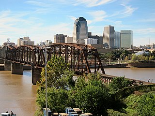
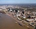
Shreveport is a city in the U.S. state of Louisiana. It is the third most populous city in Louisiana after New Orleans and Baton Rouge, respectively. The Shreveport–Bossier City metropolitan area, with a population of 393,406 in 2020, is the fourth largest in Louisiana, though 2020 census estimates placed its population at 397,590. The bulk of Shreveport is in Caddo Parish, of which it is the parish seat. It extends along the west bank of the Red River into neighboring Bossier Parish. The United States Census Bureau's 2020 census tabulation for the city's population was 187,593, though the American Community Survey's census estimates determined 189,890 residents.

<span class="mw-page-title-main">Longview, Texas</span> City in Gregg County, Texas, United States

Longview is a city in the U.S. state of Texas, and county seat of Gregg County; a small part of Longview extends into the western portion of neighboring Harrison County. Longview is located in East Texas, where Interstate 20 and U.S. Highways 80 and 259 converge just north of the Sabine River. According to the 2020 U.S. census, the city had a population of 81,638. Longview is the principal city of the Longview metropolitan statistical area, comprising Gregg, Upshur, and Rusk Counties. The population of the metropolitan area as of 2017 census estimates was 217,481.

<span class="mw-page-title-main">Ark-La-Tex</span> Region

The Ark-La-Tex is a socio-economic tri-state region where the Southern U.S. states of Arkansas, Louisiana, and Texas join together. The region contains portions of Northwest Louisiana, Northeast Texas, and South Arkansas as well as the extreme southeastern tip of Oklahoma, in McCurtain County, partly centered upon the Red River, which flows along the Texas–Oklahoma state line into Southwestern Arkansas and Northwest Louisiana.

<span class="mw-page-title-main">Dallas–Fort Worth metroplex</span> Conurbation in Texas, United States

The Dallas–Fort Worth metroplex, officially designated Dallas–Fort Worth–Arlington by the U.S. Office of Management and Budget, is a conurbated metropolitan statistical area in the U.S. state of Texas encompassing 11 counties and anchored by the major cities of Dallas and Fort Worth. It is the economic and cultural hub of North Texas. Residents of the area also refer to it as DFW, or the Metroplex. The Dallas–Fort Worth–Arlington metropolitan statistical area's population was 7,637,387 according to the U.S. Census Bureau's 2020 census, making it the most populous metropolitan area in both Texas and the Southern United States, the fourth-largest in the U.S., and the tenth-largest in the Americas. In 2016, the Dallas–Fort Worth metroplex had the highest annual population growth in the United States.

<span class="mw-page-title-main">Sun Belt</span> Region of the southern United States

The Sun Belt is a region of the United States generally considered to stretch across the Southeast and Southwest. Another rough definition of the region is the area south of the 36th parallel. Several climates can be found in the region — desert/semi-desert, Mediterranean (California), humid subtropical and tropical.

<span class="mw-page-title-main">Central Time Zone</span> Time zone in North America

The North American Central Time Zone (CT) is a time zone in parts of Canada, the United States, Mexico, Central America, some Caribbean islands, and part of the Eastern Pacific Ocean.

<span class="mw-page-title-main">Southeastern United States</span> Eastern portion of the Southern United States

The Southeastern United States, also referred to as the American Southeast or simply the Southeast, is a geographical region of the United States. It is located broadly on the eastern portion of the southern United States and the southern portion of the eastern United States. It comprises at least a core of states on the lower East Coast of the United States and eastern Gulf Coast. Expansively, it reaches as far north as West Virginia and Maryland, and stretching as far west as Arkansas and Louisiana. There is no official U.S. government definition of the region, though various agencies and departments use different definitions.

<span class="mw-page-title-main">West South Central states</span> U.S. Census Bureau region

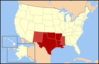
The West South Central States form one of the nine Census Bureau Divisions of the United States that are officially designated by the United States Census Bureau.

<span class="mw-page-title-main">Central United States</span> Geographical region of the United States

The Central United States is sometimes conceived as between the Eastern and Western as part of a three-region model, roughly coincident with the U.S. Census's definition of the Midwestern United States plus the western and central portions of the U.S. Census's definition of the Southern United States. The Central States are typically considered to consist of North Dakota, South Dakota, Nebraska, Kansas, Oklahoma, Texas, Minnesota, Iowa, Missouri, Arkansas, Louisiana, Wisconsin, Illinois, Michigan, Indiana, Ohio, Kentucky, Tennessee, West Virginia, Mississippi and Alabama.

<span class="mw-page-title-main">Geography of Texas</span> Geographical Features of Texas

The geography of Texas is diverse and large. Occupying about 7% of the total water and land area of the U.S., it is the second largest state after Alaska, and is the southernmost part of the Great Plains, which end in the south against the folded Sierra Madre Oriental of Mexico. Texas is in the South Central United States of America, and is considered to form part of the U.S. South and also part of the U.S. Southwest.

<span class="mw-page-title-main">Interstate 10 in Texas</span> Section of Interstate Highway in Texas, United States

Interstate 10 (I-10) is the major east–west Interstate Highway in the Southern United States. In the U.S. state of Texas, it runs east from Anthony, at the border with New Mexico, through El Paso, San Antonio, and Houston to the border with Louisiana in Orange, Texas. At just under 880 mi (1,420 km), the Texas segment of I-10, maintained by the Texas Department of Transportation, is the longest continuous untolled freeway in North America that is operated by a single authority. It is also the longest stretch of Interstate Highway with a single designation within a single state. Mile marker 880 and its corresponding exit number in Orange, Texas, are the highest numbered mile marker and exit on any freeway in North America. After widening was completed in 2008, a portion of the highway west of Houston is now also believed to be the widest in the world, at 26 lanes when including feeders.

<span class="mw-page-title-main">Transportation in Texas</span> Overview of transportation in Texas

The Texas Department of Transportation (TxDOT) is a governmental agency and its purpose is to "provide safe, effective, and efficient movement of people and goods" throughout the state. Though the public face of the agency is generally associated with maintenance of the state's immense highway system, the agency is also responsible for aviation in the state and overseeing public transportation systems.

<span class="mw-page-title-main">Jackson metropolitan area, Mississippi</span> Metropolitan statistical area in Mississippi, United States

Jackson, MS Metropolitan Statistical Area is a metropolitan statistical area (MSA) in the central region of the U.S. state of Mississippi that covers seven counties: Copiah, Hinds, Holmes, Madison, Rankin, Simpson, and Yazoo. As of the 2010 census, the Jackson MSA had a population of 586,320. According to 2019 estimates, the population has slightly increased to 594,806. Jackson is the principal city of the MSA.

References

  1. Zimmermann, Kim Ann. "Hurricane Katrina: Facts, Damage & Aftermath". Live Science. Retrieved March 17, 2019.
  2. "New Orleans metro area population 2010-2017 | Statistic". Statista. Retrieved March 17, 2019.
  3. "Texas Demographic Center". demographics.texas.gov. Retrieved March 16, 2020.
  4. "Demographics and Geography - The official website of Louisiana". www.louisiana.gov. Retrieved March 16, 2020.
  5. "Oklahoma Cities by Population". www.oklahoma-demographics.com. Retrieved March 16, 2020.
  6. "Arkansas Cities by Population". www.arkansas-demographics.com. Retrieved March 16, 2020.
  7. "Louisiana Cities by Population". www.louisiana-demographics.com. Retrieved March 16, 2020.
  8. "Texas Cities by Population". www.texas-demographics.com. Retrieved March 16, 2020.
  9. "Distance from El Paso, TX to Phoenix, AZ". check-distance.com. Retrieved December 2, 2018.
  10. "Distance from El Paso, TX to Austin, TX". check-distance.com. Retrieved December 2, 2018.
  11. "Distance from El Paso, TX to Los Angeles, CA". check-distance.com. Retrieved December 2, 2018.
  12. "Distance from El Paso, TX to Orange, TX". check-distance.com. Retrieved December 2, 2018.
  13. "Aviation and Airports". www.dot.state.tx.us. Retrieved March 16, 2020.
  14. "Aviation and Aerospace". www.greateroklahomacity.com. Retrieved March 16, 2020.
  15. "Official Home - Louis Armstrong New Orleans International Airport". Louis Armstrong New Orleans Airport. Retrieved March 16, 2020.
  16. "Clinton National Airport". Clinton National Airport. Retrieved March 16, 2020.
  17. "Tulsa International Airport | Tulsa Airports". Tulsa Airport. Retrieved March 16, 2020.
  18. "Texas Department of Transportation". www.txdot.gov. Retrieved March 16, 2020.
  19. "LaDOTD". wwwsp.dotd.la.gov. Retrieved March 16, 2020.
  20. "Arkansas Department of Transportation - ArDOT". www.arkansashighways.com. Retrieved March 16, 2020.
  21. "Oklahoma Department of Transportation - Oklahoma Department of Transportation". www.ok.gov. Retrieved March 16, 2020.
  22. "Texas Sports Teams". www.texasoutside.com. Retrieved March 16, 2020.
  23. "Louisiana Sports Teams". Wright Realtors.com. Retrieved March 16, 2020.
  24. "Oklahoma City Sports | Professional & Collegiate Sports". www.visitokc.com. Retrieved March 16, 2020.
  25. "Sports in Louisiana". Louisiana Travel. December 4, 2013. Retrieved March 16, 2020.
  26. "Texas Sports Teams". Wright Realtors.com. Retrieved March 16, 2020.
  27. "Arkansas Sports Teams". Wright Realtors.com. Retrieved March 16, 2020.
  28. "Oklahoma Sports Teams". Wright Realtors.com. Retrieved March 16, 2020.