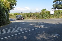
Midleton is a town in south-eastern County Cork, Ireland. It lies approximately 16 km east of Cork City on the Owenacurra River and the N25 road, which connects Cork to the port of Rosslare. A satellite town of Cork City, Midleton is part of Metropolitan Cork. It is the central hub of business for the East Cork Area. Midleton is within the Cork East Dáil constituency.

Castlemartyr is a large village in County Cork, Ireland. It is around 30 kilometres (19 mi) east of Cork city, 10 km (6 mi) east of Midleton, 16 km (10 mi) west of Youghal and 6 km (4 mi) from the coast. Approximately 1,600 people live in the village and its hinterland. It is situated on the N25 national primary road and the R632 regional road.
The N25 road is a national primary road in Ireland, forming the route from Cork to Rosslare Europort via Waterford City. The road is part of the E30 European route and a short section is also part of the E01 European route. It forms part of the proposed Atlantic Corridor route.

Little Island, County Cork, is a civil parish and mainly industrial area to the east of Cork city in Ireland. It is no longer an island since the northern channel separating it from the mainland has filled over. To the west and south is Lough Mahon, part of Cork Harbour; across a channel to the east is Fota Island. Little Island is within the Dáil constituency of Cork North-Central.
James "Bobby" Ryng was an Irish hurler who played for the Cork senior team.
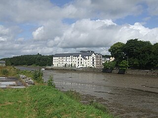
Ballinacurra is a small harbour village on the outskirts of Midleton, County Cork. It is about 18 km south east of Cork city.

Aghada is a village in County Cork, Ireland. It is situated on the eastern side of Cork Harbour, around 12 km by road south of Midleton.

Imokilly GAA is a Gaelic football and Hurling division in the east of Cork, Ireland. The division includes towns such as Midleton, Cobh, and Youghal. It is one of eight divisions of Cork County Board. It organizes competitions for the clubs within the division, from Under 12 up to the adult level. The winners of these competitions compete against other divisional champions to determine which club is the county champion. In addition, the division selects football and hurling teams from the adult teams playing at junior level or county intermediate level, and these then compete for the Cork Senior Football Championship and Cork Senior Hurling Championship. The division is known best for its hurlers, and in recent times, players from here have dominated on the Cork GAA senior hurling team.

East Ferry is an area of East Cork overlooking Cork Harbour in Ireland. The area takes its name from a ferry which historically crossed the channel separating Garranekinnefeake promontory from Great Island.
The Jameson Experience, Midleton, is an Irish whiskey museum and visitor centre located in the Old Midleton Distillery in Midleton, County Cork, Ireland. Set over 15 acres, since opening as a visitor's centre in 1992, the old distillery has received approximately 100,000 guests per year, receiving 125,000 in 2015.
Lisgoold GAA Club is a gaelic football, hurling and ladies football club based in the village of Lisgoold, County Cork, Ireland. The club draws its support from Leamlara, Ballincurrig, Peafield and Lisgoold itself. The club fields teams in Cork GAA and Imokilly GAA divisional competitions.

The R341 road is a regional road in Ireland. It is a loop road from the N59 road in County Galway. South of the R342, the road is part of the Wild Atlantic Way.
The R588 road is a regional road in Ireland, located in west County Cork.

The R610 road is a regional road in Ireland, located in County Cork and Cork City, beginning at a junction with the N28 and terminating on Parnell Place and Grand Parade in the city centre. The road connects Monkstown, Passage West and Glenbrook in County Cork with Rochestown, Douglas and Cork city centre in Cork City.

The R616 road is a regional road in County Cork, Ireland.
The R602 road is a regional road in Ireland, located in County Cork.

The R615 road is a regional road in Ireland, located in County Cork and Cork City. It forms part of the Old Youghal Road.

The R608 road is a regional road in Ireland, located in County Cork and Cork City. It intersects the N22 three times and goes from Cork city centre to Ballincollig via Wilton and Bishopstown.

The R631 road is a short regional road in County Cork, Ireland. It travels from the R630 road at Whitewell Cross, Crochane, eastwards into the crossroads at Rock Street, Cloyne.

The R630 road is a regional road in southeast County Cork, Ireland. It travels from the R907 road at Midleton's Youghal Road, southwards through Ballinacurra and westwards through Rostellan, and turning south again through Whitegate. The statutary definition gives it as beginning at the R629 in Ballinacurra, but all maps and other material assign the Midleton–Ballinacurra stretch to the R630.

