National Register of Historic Places listings in west Denver

Last updated
The 78 official neighborhoods of the City and County of Denver. Denver neighborhoods.gif
The 78 official neighborhoods of the City and County of Denver.

This is a list of the National Register of Historic Places listings in West Denver, Colorado.

Contents

This is intended to be a complete list of the properties and districts on the National Register of Historic Places in western Denver, Colorado, United States. West Denver is defined as being all of the city west of the South Platte River. The locations of National Register properties and districts may be seen in an online map. [1]

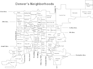
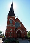
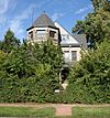
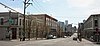
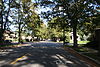
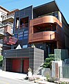
There are 312 properties and districts listed on the National Register in Denver. West Denver includes 48 of these properties and districts, including 2 that extend into other regions; the city's remaining properties and districts are listed elsewhere. Another property was once listed but has been removed.


    This National Park Service list is complete through NPS recent listings posted March 22, 2024. [2]

Current listings

[3] Name on the Register [4] ImageDate listed [5] Location NeighborhoodDescription
1 19th Street Bridge
19th Street Bridge 19th Street Bridge Denver CO.jpg
19th Street Bridge
February 4, 1985
(#85000201)
19th St.
39°45′36″N105°00′12″W / 39.76°N 105.0033°W / 39.76; -105.0033 (19th Street Bridge)
Highland Extends into Union Station in Downtown Denver
2 All Saints Episcopal Church
All Saints Episcopal Church All Saints Denver.JPG
All Saints Episcopal Church
June 23, 1978
(#78000839)
2222 W. 32nd Ave.
39°45′43″N105°00′49″W / 39.7619°N 105.0136°W / 39.7619; -105.0136 (All Saints Episcopal Church)
Highland
3 Avoca Lodge
Avoca Lodge Avoca Lodge Denver CO.jpg
Avoca Lodge
January 26, 1990
(#89002373)
2690 S. Wadsworth Boulevard
39°40′05″N105°04′50″W / 39.6681°N 105.0806°W / 39.6681; -105.0806 (Avoca Lodge)
Bear Valley
4 Berkeley Lake Park
Berkeley Lake Park Berkeley Lake Park.JPG
Berkeley Lake Park
September 17, 1986
(#86002255)
Roughly bounded by the northern side of Berkeley Lake, Tennyson St., W. 46th Ave., and Sheridan Boulevard
39°46′56″N105°02′52″W / 39.7822°N 105.0478°W / 39.7822; -105.0478 (Berkeley Lake Park)
Berkeley
5 Berkeley School
Berkeley School Berkeley School.JPG
Berkeley School
November 1, 1996
(#96001237)
5025-5055 Lowell Boulevard
39°47′19″N105°02′04″W / 39.7886°N 105.0344°W / 39.7886; -105.0344 (Berkeley School)
Regis
6 William Norman Bowman House-Yamecila
William Norman Bowman House-Yamecila William Norman Bowman House.JPG
William Norman Bowman House-Yamecila
March 14, 1991
(#91000295)
325 King St.
39°43′20″N105°02′03″W / 39.72235°N 105.03419°W / 39.72235; -105.03419 (William Norman Bowman House-Yamecila)
Barnum Mansion built in 1910, now the Savio House operated by the Denver Lions Club
7 Bryant-Webster Elementary School
Bryant-Webster Elementary School Bryant Webster Elementary School.JPG
Bryant-Webster Elementary School
December 7, 1995
(#95001421)
3635 Quivas St.
39°46′03″N105°00′28″W / 39.7675°N 105.0078°W / 39.7675; -105.0078 (Bryant-Webster Elementary School)
Highland
8 Building at 1389 Stuart Street
Building at 1389 Stuart Street 1389 Stuart Street Denver.JPG
Building at 1389 Stuart Street
July 19, 1982
(#82002287)
1389 Stuart St.
39°44′18″N105°02′35″W / 39.73830°N 105.04316°W / 39.73830; -105.04316 (Building at 1389 Stuart Street)
West Colfax Queen Anne-style house built in 1890.
9 Building at 1390 Stuart Street
Building at 1390 Stuart Street McNulty House.JPG
Building at 1390 Stuart Street
July 19, 1982
(#82002288)
1390 Stuart St.
39°44′17″N105°02′32″W / 39.7381°N 105.0422°W / 39.7381; -105.0422 (Building at 1390 Stuart Street)
West Colfax
10 Building at 1435 Stuart Street
Building at 1435 Stuart Street 1435 Stuart Street Denver.JPG
Building at 1435 Stuart Street
July 19, 1982
(#82002289)
1435 Stuart St.
39°44′22″N105°02′33″W / 39.7394°N 105.0425°W / 39.7394; -105.0425 (Building at 1435 Stuart Street)
West Colfax
11 Building at 1444 Stuart Street
Building at 1444 Stuart Street Spangler House.JPG
Building at 1444 Stuart Street
July 19, 1982
(#82002290)
1444 Stuart St.
39°44′23″N105°02′32″W / 39.7397°N 105.0422°W / 39.7397; -105.0422 (Building at 1444 Stuart Street)
West Colfax
12 Building at 1471 Stuart Street
Building at 1471 Stuart Street 1471 Stuart Street Denver.JPG
Building at 1471 Stuart Street
July 19, 1982
(#82002291)
1471 Stuart St.
39°44′23″N105°02′33″W / 39.7397°N 105.0425°W / 39.7397; -105.0425 (Building at 1471 Stuart Street)
West Colfax
13 CB&Q Denver Shops Powerhouse
CB&Q Denver Shops Powerhouse CB&Q Denver Shops Powerhouse Denver Co east side.jpg
CB&Q Denver Shops Powerhouse
March 15, 2021
(#100006230)
5151 Bannock St.
39°47′21″N104°59′33″W / 39.7893°N 104.9924°W / 39.7893; -104.9924 (CB&Q Denver Shops Powerhouse)
14 Denver Tramway Powerhouse
Denver Tramway Powerhouse Denver Tramway Powerhouse.JPG
Denver Tramway Powerhouse
September 8, 2001
(#01000940)
1416 Platte St.
39°45′18″N105°00′32″W / 39.755°N 105.0089°W / 39.755; -105.0089 (Denver Tramway Powerhouse)
Highland
15 Dickinson Branch Library
Dickinson Branch Library Dickinson Branch Library.JPG
Dickinson Branch Library
March 28, 2002
(#02000262)
1545 Hooker St.
39°44′29″N105°01′41″W / 39.7414°N 105.0281°W / 39.7414; -105.0281 (Dickinson Branch Library)
West Colfax
16 William J. Dunwoody House
William J. Dunwoody House Dunwoody House.JPG
William J. Dunwoody House
April 11, 1979
(#79000582)
2637 W. 26th Ave.
39°45′18″N105°01′11″W / 39.755°N 105.0197°W / 39.755; -105.0197 (William J. Dunwoody House)
Jefferson Park
17 Elitch Theatre
Elitch Theatre Elitch Theater Denver CO.jpg
Elitch Theatre
March 21, 1978
(#78000844)
W. 38th Ave. and Tennyson St.
39°46′06″N105°02′46″W / 39.7683°N 105.0461°W / 39.7683; -105.0461 (Elitch Theatre)
West Highland
18 Fort Logan National Cemetery
Fort Logan National Cemetery Fort logan national cemetery 3.jpg
Fort Logan National Cemetery
November 29, 2016
(#16000810)
3698 S. Sheridan Blvd.
39°38′53″N105°02′52″W / 39.6481°N 105.0477°W / 39.6481; -105.0477 (Fort Logan National Cemetery)
19 Fourth Church of Christ, Scientist
Fourth Church of Christ, Scientist Fourth Church of Christ, Scientist Denver CO.jpg
Fourth Church of Christ, Scientist
April 21, 2004
(#04000336)
3101 W. 31st Ave.
39°45′40″N105°01′37″W / 39.7611°N 105.0269°W / 39.7611; -105.0269 (Fourth Church of Christ, Scientist)
West Highland
20 Hanigan-Canino Terrace
Hanigan-Canino Terrace Hanigan-Canino Terrace.JPG
Hanigan-Canino Terrace
November 25, 1987
(#87001289)
1421-1435 W. 35th Ave.
39°45′57″N105°00′12″W / 39.7658°N 105.0033°W / 39.7658; -105.0033 (Hanigan-Canino Terrace)
Highland
21 Highland Park
Highland Park Highland Park.JPG
Highland Park
September 17, 1986
(#86002248)
Roughly bounded by Highland Park Pl., Federal Boulevard, and Fairview Pl.
39°45′47″N105°01′34″W / 39.7631°N 105.0261°W / 39.7631; -105.0261 (Highland Park)
West Highland
22 Highland Park Historic District
Highland Park Historic District Highland Park HD Denver.JPG
Highland Park Historic District
January 18, 1985
(#85000082)
Bounded by Zuni St., Dunkeld Pl., Clay St., and 32nd Ave.
39°45′39″N105°01′02″W / 39.7608°N 105.0172°W / 39.7608; -105.0172 (Highland Park Historic District)
Highland
23 Highlands Masonic Lodge
Highlands Masonic Lodge Highlands Masonic Lodge.JPG
Highlands Masonic Lodge
November 22, 1995
(#95001337)
3220 Federal Boulevard
39°45′45″N105°01′27″W / 39.7625°N 105.024167°W / 39.7625; -105.024167 (Highlands Masonic Lodge)
Highland
24 Inspiration Point
Inspiration Point Inspiration Point Denver.JPG
Inspiration Point
September 17, 1986
(#86002259)
Roughly bounded by W. 50th Ave., Sheridan Boulevard, W. 49th Ave., and Fenton St.
39°47′11″N105°03′22″W / 39.786389°N 105.056111°W / 39.786389; -105.056111 (Inspiration Point)
Regis
25 John and Nettie Kirtley House March 18, 2024
(#100010080)
4524 Vrain Street
39°46′44″N105°02′46″W / 39.7789°N 105.0462°W / 39.7789; -105.0462 (John and Nettie Kirtley House)
26 Loretto Heights Academy
Loretto Heights Academy Loretto Heights Academy.JPG
Loretto Heights Academy
September 18, 1975
(#75000510)
3001 S. Federal Boulevard
39°39′42″N105°01′38″W / 39.661667°N 105.027222°W / 39.661667; -105.027222 (Loretto Heights Academy)
Harvey Park South
27 Machebeuf Hall November 30, 2023
(#100009576)
3040 South Loretto Way
39°39′41″N105°01′45″W / 39.6614°N 105.0293°W / 39.6614; -105.0293 (Machebeuf Hall)
28 Frederick W. Neef House
Frederick W. Neef House Neef House.JPG
Frederick W. Neef House
October 25, 1979
(#79000588)
2143 Grove St.
39°44′59″N105°01′35″W / 39.749722°N 105.026389°W / 39.749722; -105.026389 (Frederick W. Neef House)
Sloan Lake
29 Niblock-Yacovetta Terrace
Niblock-Yacovetta Terrace Niblock-Yacovetta Terrace.JPG
Niblock-Yacovetta Terrace
June 27, 1986
(#86001450)
1301-1319 W. 35th Ave.
39°45′57″N105°00′12″W / 39.765833°N 105.003333°W / 39.765833; -105.003333 (Niblock-Yacovetta Terrace)
Highland
30 Old Highland Business District
Old Highland Business District Old Highland Business District.JPG
Old Highland Business District
July 17, 1979
(#79000589)
15th and Boulder Sts.
39°45′29″N105°00′38″W / 39.758056°N 105.010556°W / 39.758056; -105.010556 (Old Highland Business District)
Highland
31 Oriental Theater
Oriental Theater Oriental Theater.JPG
Oriental Theater
September 26, 1997
(#97001167)
4329-39 W. 44th Ave.
39°46′37″N105°02′35″W / 39.776944°N 105.043056°W / 39.776944; -105.043056 (Oriental Theater)
Berkeley
32 Our Lady of Mount Carmel Church
Our Lady of Mount Carmel Church Our Lady of Mt Carmel Church (Denver) from northeast in 2009.jpg
Our Lady of Mount Carmel Church
April 3, 2017
(#100000820)
3517-3549 Navajo St.
39°45′59″N105°00′15″W / 39.766442°N 105.004135°W / 39.766442; -105.004135 (Our Lady of Mount Carmel Church)
33 Overland Cotton Mill
Overland Cotton Mill Overland Cotton Mill.JPG
Overland Cotton Mill
April 3, 2001
(#01000288)
1314 W. Evans Ave.
39°40′36″N105°00′13″W / 39.676667°N 105.003611°W / 39.676667; -105.003611 (Overland Cotton Mill)
College View and South Platte
34 Potter Highlands Historic District
Potter Highlands Historic District Potter Highlands Denver.JPG
Potter Highlands Historic District
January 22, 1986
(#86000097)
Roughly bounded by W. 38th Ave., Zuni St., W. 32nd Ave., and Federal Boulevard
39°45′53″N105°01′09″W / 39.764722°N 105.019167°W / 39.764722; -105.019167 (Potter Highlands Historic District)
Highland
35 Rocky Mountain Hotel
Rocky Mountain Hotel Rocky Mountain Hotel.JPG
Rocky Mountain Hotel
April 21, 1983
(#83001314)
2301 7th St.
39°45′08″N105°00′53″W / 39.75224°N 105.014639°W / 39.75224; -105.014639 (Rocky Mountain Hotel)
Jefferson Park Surviving portion of historic Zang Brewery complex.
36 Rocky Mountain Lake Park
Rocky Mountain Lake Park RockyMountainLakePark.JPG
Rocky Mountain Lake Park
September 17, 1986
(#86002250)
Roughly bounded by Interstate 70, Federal Boulevard, W. 46th Ave., and Lowell Boulevard
39°46′55″N105°01′47″W / 39.781944°N 105.029722°W / 39.781944; -105.029722 (Rocky Mountain Lake Park)
Berkeley
37 Romeo Block
Romeo Block Romeo Block.JPG
Romeo Block
January 4, 1996
(#95001485)
2944 Zuni St.
39°45′33″N105°00′54″W / 39.759167°N 105.015°W / 39.759167; -105.015 (Romeo Block)
Highland
38 Amos H. Root Building
Amos H. Root Building RootBuilding.JPG
Amos H. Root Building
March 27, 1980
(#80000894)
1501-1529 Platte St.
39°45′24″N105°00′32″W / 39.756667°N 105.008889°W / 39.756667; -105.008889 (Amos H. Root Building)
Highland
39 St. Dominic's Church
St. Dominic's Church Saint Dominic's Church.JPG
St. Dominic's Church
November 1, 1996
(#96001236)
3005 W. 29th Ave.
39°45′32″N105°01′31″W / 39.758889°N 105.025278°W / 39.758889; -105.025278 (St. Dominic's Church)
West Highland
40 St. Elizabeth's Retreat Chapel
St. Elizabeth's Retreat Chapel Saint Elizabeth's Retreat Chapel.JPG
St. Elizabeth's Retreat Chapel
May 24, 1976
(#76000556)
2825 W. 32nd Ave.
39°45′46″N105°01′19″W / 39.762778°N 105.021944°W / 39.762778; -105.021944 (St. Elizabeth's Retreat Chapel)
Highland
41 St. Joseph's Polish Roman Catholic Church
St. Joseph's Polish Roman Catholic Church SaintJosephChurchDenver.JPG
St. Joseph's Polish Roman Catholic Church
April 21, 1983
(#83001315)
517 E. 46th Ave.
39°46′49″N104°58′54″W / 39.780278°N 104.981667°W / 39.780278; -104.981667 (St. Joseph's Polish Roman Catholic Church)
Globeville
42 St. Patrick Mission Church
St. Patrick Mission Church Saint Patrick Mission Church.JPG
St. Patrick Mission Church
November 14, 1979
(#79000593)
3325 Pecos St.
39°45′49″N105°00′23″W / 39.763611°N 105.006389°W / 39.763611; -105.006389 (St. Patrick Mission Church)
Highland
43 George Schmidt House
George Schmidt House George Schmidt House.JPG
George Schmidt House
October 29, 1976
(#76000554)
2345 7th St.
39°45′10″N105°00′52″W / 39.752778°N 105.014444°W / 39.752778; -105.014444 (George Schmidt House)
Jefferson Park
44 South Platte River Bridges
South Platte River Bridges South Platte River Bridges.JPG
South Platte River Bridges
October 15, 2002
(#02001128)
Interstate 25 at milepost 210.53
39°44′36″N105°00′56″W / 39.743333°N 105.015556°W / 39.743333; -105.015556 (South Platte River Bridges)
Jefferson Park and Sun Valley Extends into Auraria in Northeast Denver
45 Stonemen's Row Historic District
Stonemen's Row Historic District StonemensRow.JPG
Stonemen's Row Historic District
January 5, 1984
(#84000824)
Southern side of 28th Ave. between Umatilla and Vallejo Sts.
39°45′26″N105°00′43″W / 39.757222°N 105.011944°W / 39.757222; -105.011944 (Stonemen's Row Historic District)
Highland
46 Tallmadge and Boyer Block
Tallmadge and Boyer Block Tallmadge and Boyer Block.JPG
Tallmadge and Boyer Block
October 21, 1982
(#82001013)
2926-2942 Zuni St.
39°45′32″N105°00′54″W / 39.758889°N 105.015°W / 39.758889; -105.015 (Tallmadge and Boyer Block)
Highland
47 Tilden School for Teaching Health
Tilden School for Teaching Health Tilden School for Teaching Health.JPG
Tilden School for Teaching Health
September 7, 1995
(#95001068)
Junction of W. Fairview Pl. and Grove St.
39°45′51″N105°01′41″W / 39.764167°N 105.028056°W / 39.764167; -105.028056 (Tilden School for Teaching Health)
West Highland
48 West Forty-sixth Avenue Parkway
West Forty-sixth Avenue Parkway West Forty-sixth Avenue Parkway.JPG
West Forty-sixth Avenue Parkway
September 17, 1986
(#86002249)
W. 46th Ave. Parkway from Stuart St. to Grove St.
39°46′49″N105°01′33″W / 39.780278°N 105.025833°W / 39.780278; -105.025833 (West Forty-sixth Avenue Parkway)
Berkeley

Former listing

[3] Name on the RegisterImageDate listedDate removedLocationDescription
1 Wheeler House
Wheeler House Wheeler House Denver.JPG
Wheeler House
March 1, 2000
(#00000105)
January 14, 20101917 W. 32nd Ave.
39°45′44″N105°00′34″W / 39.7622°N 105.0094°W / 39.7622; -105.0094 (Wheeler House)
Demolished in 2005. [6]

See also

Related Research Articles

<span class="mw-page-title-main">National Register of Historic Places listings in Colorado</span> List of National Register of Historic Places in the U.S. State of Colorado

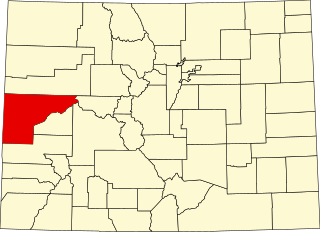
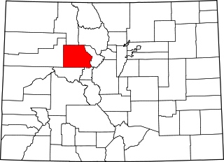
There are more than 1,500 properties and historic districts in the U.S. State of Colorado listed on the National Register of Historic Places. They are distributed over 63 of Colorado's 64 counties; only the City and County of Broomfield currently has none.

<span class="mw-page-title-main">National Register of Historic Places listings in Denver</span> List of National Register of Historic Places in Denver, Colorado, United States

There are 312 properties and districts listed on the National Register of Historic Places in the City and County of Denver, the capital of the U.S. State of Colorado.
     This National Park Service list is complete through NPS recent listings posted March 22, 2024.

<span class="mw-page-title-main">National Register of Historic Places listings in El Paso County, Colorado</span> List of National Register of Historic Places in El Paso County, Colorado, United States

This is a list of the National Register of Historic Places listings in El Paso County, Colorado.

<span class="mw-page-title-main">National Register of Historic Places listings in Jefferson County, Colorado</span> List of National Register of Historic Places in Jefferson County, Colorado, United States

This is a list of the National Register of Historic Places listings in Jefferson County, Colorado.

<span class="mw-page-title-main">National Register of Historic Places listings in Pueblo County, Colorado</span> List of National Register of Historic Places in Pueblo County, Colorado, United States

This is a list of the National Register of Historic Places listings in Pueblo County, Colorado, USA.

<span class="mw-page-title-main">National Register of Historic Places listings in Weld County, Colorado</span> List of National Register of Historic Places in Weld County, Colorado, United States

This is a list of the National Register of Historic Places listings in Weld County, Colorado.

<span class="mw-page-title-main">National Register of Historic Places listings in Clear Creek County, Colorado</span> List of National Register of Historic Places in Clear Creek County, Colorado, United States

This is a list of the National Register of Historic Places listings in Clear Creek County, Colorado.

<span class="mw-page-title-main">National Register of Historic Places listings in Douglas County, Colorado</span> List of National Register of Historic Places in Douglas County, Colorado, United States

This is a list of the National Register of Historic Places listings in Douglas County, Colorado.

<span class="mw-page-title-main">National Register of Historic Places listings in Mesa County, Colorado</span> List of National Register of Historic Places in Mesa County, Colorado, United States

This is a list of the National Register of Historic Places listings in Mesa County, Colorado.

<span class="mw-page-title-main">National Register of Historic Places listings in Las Animas County, Colorado</span> List of National Register of Historic Places in Las Animas County, Colorado, United States

This is a list of the National Register of Historic Places listings in Las Animas County, Colorado.

<span class="mw-page-title-main">National Register of Historic Places listings in Arapahoe County, Colorado</span> List of National Register of Historic Places in Arapahoe County, Colorado, United States

This is a list of the National Register of Historic Places listings in Arapahoe County, Colorado.

<span class="mw-page-title-main">National Register of Historic Places listings in Park County, Colorado</span> List of National Register of Historic Places in Park County, Colorado, United States

This is a list of the National Register of Historic Places listings in Park County, Colorado.

<span class="mw-page-title-main">National Register of Historic Places listings in Garfield County, Colorado</span> List of National Register of Historic Places in Garfield County, Colorado, United States

This is a list of the National Register of Historic Places listings in Garfield County, Colorado.

<span class="mw-page-title-main">National Register of Historic Places listings in Adams County, Colorado</span> List of National Register of Historic Places in Adams County, Colorado, United States

This is a list of the National Register of Historic Places listings in Adams County, Colorado.

<span class="mw-page-title-main">National Register of Historic Places listings in Eagle County, Colorado</span> List of National Register of Historic Places in Eagle County, Colorado, United States

This is a list of the National Register of Historic Places listings in Eagle County, Colorado.

<span class="mw-page-title-main">National Register of Historic Places listings in northeast Denver</span> List of National Register of Historic Places in northeast Denver, Colorado, United States

This is a list of the National Register of Historic Places listings in Northeast Denver, Colorado.

<span class="mw-page-title-main">National Register of Historic Places listings in southeast Denver</span> List of National Register of Historic Places in southeast Denver, Colorado, United States

This is a list of the National Register of Historic Places listings in Southeast Denver, Colorado.

<span class="mw-page-title-main">National Register of Historic Places listings in downtown Denver</span> List of National Register of Historic Places in downtown Denver, Colorado, United States

This is a list of the National Register of Historic Places listings in Downtown Denver, Colorado.

<span class="mw-page-title-main">National Register of Historic Places listings in Lake County, Colorado</span> List of National Register of Historic Places in Lake County, Colorado, United States

This is a list of the National Register of Historic Places listings in Lake County, Colorado.

<span class="mw-page-title-main">National Register of Historic Places listings in Summit County, Colorado</span> List of National Register of Historic Places in Summit County, Colorado, United States

This is a list of the National Register of Historic Places listings in Summit County, Colorado.

References

  1. The latitude and longitude information provided in this table was derived originally from the National Register Information System, which has been found to be fairly accurate for about 99% of listings. Some locations in this table may have been corrected to current GPS standards.
  2. National Park Service, United States Department of the Interior, "National Register of Historic Places: Weekly List Actions", retrieved March 22, 2024.
  3. 1 2 Numbers represent an alphabetical ordering by significant words. Various colorings, defined here, differentiate National Historic Landmarks and historic districts from other NRHP buildings, structures, sites or objects.
  4. "National Register Information System". National Register of Historic Places . National Park Service. July 9, 2010.
  5. The eight-digit number below each date is the number assigned to each location in the National Register Information System database, which can be viewed by clicking the number.
  6. "Colorado Office of Archaeology and Historic Preservation | Properties removed from the National and State Registers". Archived from the original on 2012-08-18. Retrieved 2012-08-17.

39°44′21″N104°59′06″W / 39.7392°N 104.9849°W / 39.7392; -104.9849 (Denver)