This article needs additional citations for verification .(May 2008) (Learn how and when to remove this template message) |
| Arghandab District ارغنداب | |
|---|---|
| District | |
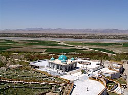
The Shrine of Baba Wali in the Arghandab district. | |
 Arghandab District Location in Afghanistan (Dot on the town of Arghandab) | |
| Coordinates: 31°39′17″N65°38′58″E / 31.65472°N 65.64944°E Coordinates: 31°39′17″N65°38′58″E / 31.65472°N 65.64944°E | |
| Country | |
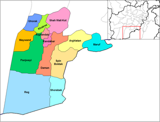
| Province | Kandahar Province |
| Center | Town of Arghandab |
| Elevation | 1,112 m (3,648 ft) |
| Population (2006) | |
| • Total | 54,900 |
| Time zone | + 4.30 |
| Website | Arghandab.gov |
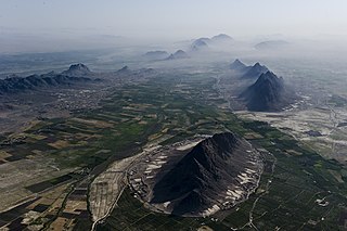
Arghandab (Pashto/Persian : ارغنداب) is a district in the central part of Kandahar Province, Afghanistan. It borders Panjwai and Khakrez districts to the west, Shah Wali Kot District to the north and east and Kandahar District to the east and south.

Persian, also known by its endonym Farsi, is one of the Western Iranian languages within the Indo-Iranian branch of the Indo-European language family. It is primarily spoken in Iran, Afghanistan, and Tajikistan, Uzbekistan and some other regions which historically were Persianate societies and considered part of Greater Iran. It is written right to left in the Persian alphabet, a modified variant of the Arabic script.

A district is a type of administrative division that, in some countries, is managed by local government. Across the world, areas known as "districts" vary greatly in size, spanning regions or counties, several municipalities, subdivisions of municipalities, school district, or political district.

Kandahar is one of the thirty-four provinces of Afghanistan, located in the southern part of the country next to Pakistan. It is surrounded by Helmand in the west, Uruzgan in the north and Zabul Province in the east. Its capital is the city of Kandahar, which is located on the Arghandab River. The greater region surrounding the province is called Loy Kandahar.
Contents
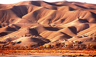
The population, as of 2006, was 54,900. The district centre is Arghandab, located northwest of Kandahar. The Arghandab River flows through the district in its eastern part West from the district center, and the area is irrigated by the Helmand and Arghandab Valley Authority. [1] The climate, river and irrigation allow the inhabitants to aggregate several different forms of produce. The predominate agricultural crops in this region are pomegranates, grapes, plums, and marijuana.

The town of Arghandab is the center of Arghandab District in Kandahar Province, Afghanistan, in the valley of Arghandab River northwest from Kandahar. It is located on 31.6547°N 65.6494°E at an elevation of 1,112 metres (3,648 ft).

Arghandab is a river in Afghanistan, about 400 km (250 mi) in length. It rises in the Hazarajat country north-west of Ghazni, flows south-west passing near the city of Kandahar, and then falls into the Helmand 30 km (19 mi) below Girishk. In its lower course it is much used for irrigation, under the control of the Helmand and Arghandab Valley Authority, and the valley is cultivated and populous; yet the water is said to be somewhat brackish. It is doubtful whether the ancient Arachotus is to be identified with the Arghandab or with its chief confluent the Tarnak, which joins it on the left 50 km (31 mi) southwest of Kandahar. The Tarnak, which flows south of Kandahar, is much shorter and less copious.

The Helmand and Arghandab Valley Authority (HAVA) based in Lashkar Gah, Afghanistan, originally named the Helmand Valley Authority (HVA) until its expansion in 1965, was established on December 4, 1952 as an agency of the Afghan Government. The agency was modelled on the Tennessee Valley Authority in the United States, with a remit covering lands in Farah Province, Ghazni Province, Helmand Province, Herat Province, and Kandahar Province.