Jones County, Texas

Last updated

Jones County
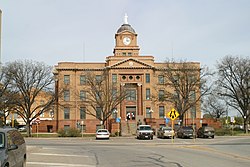
Jones County Courthouse Anson Texas 2009.JPG
Jones County Courthouse in Anson, Texas
Map of Texas highlighting Jones County.svg
Location within the U.S. state of Texas
Texas in United States.svg
Texas's location within the U.S.
Coordinates: 32°44′N99°53′W / 32.74°N 99.88°W / 32.74; -99.88
CountryFlag of the United States.svg United States
StateFlag of Texas.svg  Texas
Founded1881
Named for Anson Jones
Seat Anson
Largest city Abilene
Area
  Total
937.1 sq mi (2,427 km2)
  Land928.6 sq mi (2,405 km2)
  Water8.6 sq mi (22 km2)  0.9%
Population
 (2020)
  Total
19,663
  Density21/sq mi (8.1/km2)
Time zone UTC−6 (Central)
  Summer (DST) UTC−5 (CDT)
Congressional district 19th
Website www.co.jones.tx.us

Jones County is a county located in the U.S. state of Texas. As of the 2020 census, its population was 19,663. [1] Its county seat is Anson. [2] The county was created in 1858 and organized in 1881. [3] Both the county and its county seat are named for Anson Jones, the fourth and final president of the Republic of Texas. [4]

Contents

Jones County is included in the Abilene, Texas, metropolitan statistical area.

Geography

According to the U.S. Census Bureau, the county has a total area of 937 square miles (2,430 km2), of which 8.6 square miles (22 km2) (0.9%) are covered by water. [5]

Major highways

Adjacent counties

Demographics

Historical population
CensusPop.Note
1880 546
1890 3,797595.4%
1900 7,05385.8%
1910 24,299244.5%
1920 22,323−8.1%
1930 24,2338.6%
1940 23,378−3.5%
1950 22,147−5.3%
1960 19,299−12.9%
1970 16,106−16.5%
1980 17,2687.2%
1990 16,490−4.5%
2000 20,78526.0%
2010 20,202−2.8%
2020 19,663−2.7%
U.S. Decennial Census [6]
1850–2010 [7] 2010 [8] 2020 [9]
Jones County, Texas – Racial and ethnic composition
Note: the US Census treats Hispanic/Latino as an ethnic category. This table excludes Latinos from the racial categories and assigns them to a separate category. Hispanics/Latinos may be of any race.
Race / Ethnicity (NH = Non-Hispanic)Pop 2000 [10] Pop 2010 [8] Pop 2020 [9] % 2000% 2010% 2020
White alone (NH)13,75212,54911,48566.16%62.12%58.41%
Black or African American alone (NH)2,3682,2921,97811.39%11.35%10.06%
Native American or Alaska Native alone (NH)6262660.30%0.31%0.34%
Asian alone (NH)91761110.44%0.38%0.56%
Pacific Islander alone (NH)2140.01%0.00%0.02%
Other race alone (NH)1927410.09%0.13%0.21%
Mixed race or Multiracial (NH)1451864740.70%0.92%2.41%
Hispanic or Latino (any race)4,3465,0095,50420.91%24.79%27.99%
Total20,78520,20219,663100.00%100.00%100.00%

As of the census [11] of 2000, 20,785 people, 6,140 households, and 4,525 families resided in the county. The population density was 22 people per square mile (8.5 people/km2). The 7,236 housing units averaged 8 units per square mile (3.1/km2). The racial makeup of the county was 78.80% White, 11.51% Black or African American, 0.49% Native American, 0.47% Asian, 7.47% from other races, and 1.27% from two or more races. About 20.9% of the population was Hispanic or Latino of any race.

Of the 6,140 households, 33.40% had children under the age of 18 living with them, 59.60% were married couples living together, 10.10% had a female householder with no husband present, and 26.30% were not families. About 24.1% of all households were made up of individuals, and 13.40% had someone living alone who was 65 years of age or older. The average household size was 2.58 and the average family size was 3.06.

In the county, theage distribution was 22.50% under 18, 11.10% from 18 to 24, 31.50% from 25 to 44, 21.00% from 45 to 64, and 14.00% who were 65 or older. The median age was 36 years. For every 100 females, there were 150.10 males. For every 100 females age 18 and over, there were 159.70 males.

The median income for a household in the county was $29,572, and for a family was $35,391. Males had a median income of $26,892 versus $17,829 for females. The per capita income for the county was $13,656. About 13.10% of families and 16.80% of the population were below the poverty line, including 22.70% of those under age 18 and 16.60% of those age 65 or over.

Government and infrastructure

The Texas Department of Criminal Justice (TDCJ) operates the Robertson Unit, located 10 miles from downtown. [12] The state Middleton transfer unit is located partially in Abilene and also in Jones County. [13] [14]

From 2007 to 2017 Republican Susan King represented Jones, Nolan, and Taylor Counties in the state house. [15]

Politics

"From their first presidential election in 1884 through 1992, the voters in Jones County have generally chosen Democratic candidates. They supported Republican candidates in 1928, 1952, 1972, 1984, and 1988." [16]

Since 2000, the majority of voters selected Republican presidential candidates, with the margin of victory for the party's candidates increasing in each election.

Jones County is part of the 71st district for elections to the Texas House of Representatives.

United States presidential election results for Jones County, Texas [17]
Year Republican Democratic Third party(ies)
No.%No.%No.%
2024 5,98886.20%90713.06%520.75%
2020 5,66083.89%99914.81%881.30%
2016 4,81980.86%93615.70%2053.44%
2012 4,26276.56%1,22622.02%791.42%
2008 4,20372.37%1,52826.31%771.33%
2004 4,25471.72%1,65827.95%190.32%
2000 4,08067.46%1,89931.40%691.14%
1996 2,35143.46%2,42244.77%63711.77%
1992 2,08835.20%2,40040.46%1,44424.34%
1988 3,00050.71%2,89848.99%180.30%
1984 4,01762.93%2,34336.71%230.36%
1980 2,76547.07%3,04351.80%661.12%
1976 2,07238.26%3,31861.26%260.48%
1972 3,20275.11%1,05024.63%110.26%
1968 1,67633.66%2,37247.64%93118.70%
1964 1,29526.32%3,62273.62%30.06%
1960 2,19644.04%2,77255.60%180.36%
1956 2,07344.32%2,59455.46%100.21%
1952 2,94152.21%2,68047.58%120.21%
1948 43210.34%3,59986.16%1463.50%
1944 3618.77%3,41783.00%3398.23%
1940 4019.79%3,68890.08%50.12%
1936 3058.24%3,39691.71%20.05%
1932 2247.03%2,93492.03%300.94%
1928 1,99555.95%1,56343.83%80.22%
1924 56615.39%3,01081.86%1012.75%
1920 27011.83%1,79278.53%2209.64%
1916 1145.34%1,79884.18%22410.49%
1912 633.89%1,30180.36%25515.75%

Communities

Cities

Unincorporated communities

Education

School districts include: [18]

The Texas Legislature designated the county as being in the Western Texas College District. [19]

Notable person

See also

Related Research Articles

<span class="mw-page-title-main">Wise County, Texas</span> County in Texas, United States

Wise County is a county in the U.S. state of Texas. As of the 2020 census, its population was 68,632. Its county seat is Decatur. Wise County is part of the Dallas–Fort Worth–Arlington metropolitan statistical area. Its Wise Eyes crime-watch program, eventually adopted by mostly rural counties in several states, was started in 1993 by then-Sheriff Phil Ryan.

<span class="mw-page-title-main">Walker County, Texas</span> County in Texas, United States

Walker County is a county located in the east central section of the U.S. state of Texas. As of the 2020 census, its population was 76,400. Its county seat is Huntsville. Initially, Walker County was named for Robert J. Walker, a legislator from Mississippi who introduced into the United States Congress the resolution to annex Texas. Walker later supported the U.S. during its Civil War and earned some enmity for it. In order to keep the county's name, the state renamed it for Samuel H. Walker, a Texas Ranger and soldier in the United States Army.

<span class="mw-page-title-main">Trinity County, Texas</span> County in Texas, United States

Trinity County is a county located in the U.S. state of Texas. As of the 2020 census, the population was 13,602. Its county seat is Groveton. The county is named for the Trinity River.

<span class="mw-page-title-main">Tom Green County, Texas</span> County in Texas, United States

Tom Green County is a county located on the Edwards Plateau in the U.S. state of Texas. As of the 2020 census, its population was 120,003. Its county seat is San Angelo. The county was created in 1874 and organized the following year. It is named for Thomas Green, who was a Confederate soldier and lawyer. Tom Green County is included in the San Angelo metropolitan statistical area; the county is home to Goodfellow Air Force Base, as well as Angelo State University, part of the Texas Tech University System.

<span class="mw-page-title-main">Terry County, Texas</span> County in Texas, United States

Terry County is a county located in the U.S. state of Texas. As of the 2020 census, its population was 11,831. Its county seat is Brownfield. The county was demarked in 1876 and organized in 1904. It is named for Benjamin Franklin Terry, a colonel in the Confederate Army. Terry County was one of 46 dry counties in the state of Texas, but is now a moist county. Terry County is one of the most productive pumpkin producing counties in the United States.

<span class="mw-page-title-main">Taylor County, Texas</span> County in Texas, United States

Taylor County is a county located in the U.S. state of Texas. As of the 2020 census, its population was 143,208. Its county seat is Abilene. The county was created in 1858 and later organized in 1878. It is named for Edward Taylor, George Taylor, and James Taylor, three brothers who died at the Battle of the Alamo.

<span class="mw-page-title-main">Shackelford County, Texas</span> County in Texas, United States

Shackelford County is a county located in the U.S. state of Texas. As of the 2020 census, its population was 3,105. Its county seat is Albany. The county was created in 1858 and later organized in 1874. Shackelford is named for Dr. Jack Shackelford, a Virginia physician who equipped soldiers at his own expense to fight in the Texas Revolution.

<span class="mw-page-title-main">Scurry County, Texas</span> County in Texas, United States

Scurry County is a county located in the U.S. state of Texas. As of the 2020 census, its population was 16,932. Its county seat is Snyder, which is the home for Western Texas College. Scurry County is named for Confederate General William Scurry. The county was created in 1876 and organized in 1884. Scurry County was one of 46 prohibition, or entirely dry, counties in the state of Texas, until a 2006 election approved the sale of beer and wine in Snyder, and a 2008 election approved the sale of liquor by the drink throughout the county.

<span class="mw-page-title-main">Hardeman County, Texas</span> County in Texas, US

Hardeman County is a county located in the U.S. state of Texas. As of the 2020 census, its population was 3,549. The county seat and largest city is Quanah. The county was created in 1858 and later organized in 1884. It is named for two brothers, Bailey Hardeman and Thomas Jones Hardeman, early Texas politicians and legislators. Hardeman County was one of 46 prohibition or entirely dry counties in the state of Texas until November 2006, when voters approved referendums to permit the legal sale of alcoholic beverages for on- and off-premises consumption.

<span class="mw-page-title-main">Fayette County, Texas</span> County in Texas, United States

Fayette County is a county located in the U.S. state of Texas. As of the 2020 census, the population was 24,435. Its county seat is La Grange. The county was created in 1837 and organized the next year.

<span class="mw-page-title-main">Eastland County, Texas</span> County in Texas, United States

Eastland County is a county located in central West Texas. As of the 2020 census, its population was 17,725. The county seat is Eastland. The county was founded in 1858 and later organized in 1873. It is named for William Mosby Eastland, a soldier during the Texas Revolution and the only officer to die as a result of the "Black Bean executions" of the Mier Expedition.

<span class="mw-page-title-main">Dawson County, Texas</span> County in Texas, United States

Dawson County is a county in the U.S. state of Texas. As of the 2020 census, its population was 12,456. The county seat is Lamesa. The county was created in 1876 and later organized in 1905. It is named for Nicholas Mosby Dawson, a soldier of the Texas Revolution. Dawson County comprises the Lamesa, TX Micropolitan Statistical Area (μSA), and it is, by population, the smallest Micropolitan Statistical Area in the United States.

<span class="mw-page-title-main">Callahan County, Texas</span> County in Texas, United States

Callahan County is a county located in the U.S. state of Texas. As of the 2020 census, the population was 13,708. Its county seat is Baird. The county was founded in 1858 and later organized in 1877. It is named for James Hughes Callahan, an American soldier in the Texas Revolution. Callahan County is included in the Abilene, Texas metropolitan statistical area.

<span class="mw-page-title-main">Brown County, Texas</span> County in Texas, United States

Brown County is a county in west-central Texas. As of the 2020 census, the population was 38,095. Its county seat is Brownwood. The county was founded in 1856 and organized in 1858. It is named for Henry Stevenson Brown, a commander at the Battle of Velasco, an early conflict between Texians and Mexicans.

<span class="mw-page-title-main">Anson, Texas</span> City in Texas, United States

Anson is a city in and the county seat of Jones County, Texas, United States. The population was 2,294 at the 2020 census. It is part of the Abilene, Texas metropolitan area. Originally named "Jones City", the town was renamed "Anson" in 1882 in honor of Anson Jones, the last president of the Republic of Texas.

<span class="mw-page-title-main">Hawley, Texas</span> City in Jones County, Texas, United States

Hawley is a city in Jones County, Texas, United States. Its population was 545 at the 2020 census.

<span class="mw-page-title-main">Hamlin, Texas</span> City in Texas, United States

Hamlin is a city in Jones and Fisher Counties in the U.S. state of Texas. The population was 1,831 at the 2020 census. The Jones County portion of Hamlin is part of the Abilene, Texas metropolitan area.

<span class="mw-page-title-main">Abilene, Texas</span> City in Texas, United States

Abilene is a city in Taylor and Jones counties, Texas, United States. Its population was 125,182 at the 2020 census. It is the principal city of the Abilene metropolitan statistical area, which had a population of 176,579 as of 2020. Abilene is home to three Christian universities: Abilene Christian University, McMurry University, and Hardin–Simmons University. It is the county seat of Taylor County. Dyess Air Force Base is located on the west side of the city.

<span class="mw-page-title-main">Lueders, Texas</span> City in Texas

Lueders is a city in Jones and Shackelford counties in the U.S. state of Texas. The population was 258 at the 2020 census. The portion of Lueders located in Jones County is part of the Abilene, Texas metropolitan area.

<span class="mw-page-title-main">Abilene metropolitan area</span> Metropolitan Statistical Area in Texas, United States

The Abilene metropolitan statistical area is a metropolitan statistical area in west-central Texas that covers three counties—Taylor, Jones, and Callahan. As of the 2020 census, the MSA had a population of 176,579.

References

  1. "Jones County, Texas". United States Census Bureau . Retrieved January 30, 2022.
  2. "Find a County". National Association of Counties. Archived from the original on May 31, 2011. Retrieved June 7, 2011.
  3. "Texas: Individual County Chronologies". Texas Atlas of Historical County Boundaries. The Newberry Library. 2008. Archived from the original on April 12, 2017. Retrieved May 24, 2015.
  4. Gannett, Henry (1905). The Origin of Certain Place Names in the United States. Govt. Print. Off. pp.  170.
  5. "2010 Census Gazetteer Files". United States Census Bureau. August 22, 2012. Retrieved May 2, 2015.
  6. "Decennial Census of Population and Housing by Decades". US Census Bureau.
  7. "Texas Almanac: Population History of Counties from 1850–2010" (PDF). Texas Almanac. Archived (PDF) from the original on October 9, 2022. Retrieved May 2, 2015.
  8. 1 2 "P2 Hispanic or Latino, and Not Hispanic or Latino by Race – 2010: DEC Redistricting Data (PL 94-171) – Jones County, Texas". United States Census Bureau .
  9. 1 2 "P2 Hispanic or Latino, and Not Hispanic or Latino by Race – 2020: DEC Redistricting Data (PL 94-171) – Jones County, Texas". United States Census Bureau .
  10. "P004: Hispanic or Latino, and Not Hispanic or Latino by Race – 2000: DEC Summary File 1 – Jones County, Texas". United States Census Bureau .
  11. "U.S. Census website". United States Census Bureau . Retrieved May 14, 2011.
  12. "Robertson Unit Archived 2010-07-25 at the Wayback Machine ." Texas Department of Criminal Justice . Retrieved on July 23, 2010.
  13. "Super Neighborhood Areas Archived 2011-06-09 at the Wayback Machine ." (Direct map link Archived June 9, 2011, at the Wayback Machine ) City of Abilene. Retrieved on July 23, 2010.
  14. "Middleton Unit Archived 2010-07-25 at the Wayback Machine ." Texas Department of Criminal Justice . Retrieved on July 23, 2010.
  15. "Susan King". Texas Legislative Reference Library. Retrieved March 12, 2014.
  16. “TSHA“
  17. Leip, David. "Dave Leip's Atlas of U.S. Presidential Elections". uselectionatlas.org. Retrieved April 11, 2018.
  18. "2020 CENSUS - SCHOOL DISTRICT REFERENCE MAP: Jones County, TX" (PDF). U.S. Census Bureau . Retrieved September 22, 2024. - Text list
  19. "Sec. 130.210. WESTERN TEXAS COLLEGE DISTRICT SERVICE AREA" . Retrieved September 22, 2024.

32°44′N99°53′W / 32.74°N 99.88°W / 32.74; -99.88