Butterfly Valley Botanical Area

Last updated
Butterfly Valley Botanical Area, with carnivorous plant habitat. Darlingtonia californica ne2.JPG
Butterfly Valley Botanical Area, with carnivorous plant habitat.
The carnivorous California Pitcher Plant - (Darlingtonia californica) in closeup. Darlingtonia californica ne1.JPG
The carnivorous California Pitcher Plant - (Darlingtonia californica) in closeup.
A bog habitat in the Butterfly Valley Botanical Area. Darlingtonia californica ne3.JPG
A bog habitat in the Butterfly Valley Botanical Area.

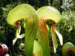
Butterfly Valley Botanical Area, in the northern Sierra Nevada, was designated a protected botanical area in 1976 due to its abundant, diverse plant life. It is located just north of Quincy, in Plumas County of northeastern California, United States. The unique plant community habitats of the nature reserve, thriving at elevations of 3,590–3,800 feet (1,090–1,160 m), are protected and managed by the Mt. Hough Ranger District of the Plumas National Forest.

Contents

Plants

The rare native carnivorous plant, Darlingtonia californica ,makes a home here at the southern extreme of its range, a range that stretches in scattered bog habitats northwest across northern california then north along western Oregon. [1]

Butterfly Valley's singular plant community also includes other carnivorous plants, two dozen species of native lilies and tiger lilies that include Lilium washingtonianum and Lilium parvum, a dozen Piperia species of native orchids, many species of native California ferns, as well as other California native plants. [1]

History

Mining

In the early 1850s, mining operations and the old mining town of Butterfly Valley occupied the area. When the mines were exhausted the town of Butterfly Valley was abandoned.

Grazing

After the mining interests left, grazing and logging operations became predominant in the valley. The Galeppi brothers increased this by bringing in their cattle into the area in the early 1900s. At about the same time as grazing began the Murphy Lumber Company began railroad logging, which the Quincy Lumber Company expanded after it purchased the Murphy Lumber Company. Logging operations stopped in 1950, leaving grazing as the primary commercial use of the valley it was designated a protected botanical area in 1976.

See also

Related Research Articles

<span class="mw-page-title-main">Sierra Nevada</span> Mountain range in the United States

The Sierra Nevada is a mountain range in the Western United States, between the Central Valley of California and the Great Basin. The vast majority of the range lies in the state of California, although the Carson Range spur lies primarily in Nevada. The Sierra Nevada is part of the American Cordillera, an almost continuous chain of mountain ranges that forms the western "backbone" of the Americas.

<span class="mw-page-title-main">Plumas County, California</span> County in California, United States

Plumas County is a county in the Sierra Nevada of the U.S. state of California. As of the 2020 census, the population was 19,790. The county seat is Quincy, and the only incorporated city is Portola. The largest community in the county is East Quincy. The county was named for the Spanish Río de las Plumas, which flows through it. The county itself is also the namesake of a native moth species, Hadena plumasata.

<span class="mw-page-title-main">Graeagle, California</span> Census-designated place in California, United States

Graeagle is a town and census-designated place in eastern Plumas County, California, United States, located along the Middle Fork Feather River in the Northern Sierra Nevada. The population was 737 as of 2010.

<span class="mw-page-title-main">Sequoia National Park</span> National park in the Sierra Nevada mountains, California, U.S.

Sequoia National Park is an American national park in the southern Sierra Nevada east of Visalia, California. The park was established on September 25, 1890, and today protects 404,064 acres of forested mountainous terrain. Encompassing a vertical relief of nearly 13,000 feet (4,000 m), the park contains the highest point in the contiguous United States, Mount Whitney, at 14,505 feet (4,421 m) above sea level. The park is south of, and contiguous with, Kings Canyon National Park; both parks are administered by the National Park Service together as Sequoia and Kings Canyon National Parks. UNESCO designated the areas as Sequoia-Kings Canyon Biosphere Reserve in 1976.

<span class="mw-page-title-main">Devils Postpile National Monument</span> National monument in California, United States

Devils Postpile National Monument is a U.S. National Monument located near Mammoth Mountain in Eastern California. The monument protects Devils Postpile, an unusual rock formation of columnar basalt, "all closely and perfectly fitted together like a vast mosaic." The monument encompasses 798 acres (323 ha) and includes two main attractions: the Devils Postpile formation and Rainbow Falls, a waterfall on the Middle Fork of the San Joaquin River. In addition, the John Muir Trail and Pacific Crest Trail merge into one trail as they pass through the monument. Excluding a small developed area containing the monument headquarters, visitor center and a campground, the National Monument lies within the borders of the Ansel Adams Wilderness.

<span class="mw-page-title-main">Feather River</span> River in California, United States

The Feather River is the principal tributary of the Sacramento River, in the Sacramento Valley of Northern California. The river's main stem is about 73 miles (117 km) long. Its length to its most distant headwater tributary is just over 210 miles (340 km). The main stem Feather River begins in Lake Oroville, where its four long tributary forks join—the South Fork, Middle Fork, North Fork, and West Branch Feather Rivers. These and other tributaries drain part of the northern Sierra Nevada, and the extreme southern Cascades, as well as a small portion of the Sacramento Valley. The total drainage basin is about 6,200 square miles (16,000 km2), with approximately 3,604 square miles (9,330 km2) above Lake Oroville.

<span class="mw-page-title-main">Lassen National Forest</span> United States national forest

Lassen National Forest is a United States national forest of 1,700 square miles (4,300 km2) in northeastern California. It is named after pioneer Peter Lassen, who mined, ranched and promoted the area to emigrant parties in the 1850s.

<span class="mw-page-title-main">Plumas National Forest</span> National Forest in northern California, United States

Plumas National Forest is a 1,146,000-acre (4,640 km2) United States National Forest located at the northern terminus of the Sierra Nevada, in northern California. The Forest was named after its primary watershed, the Rio de las Plumas, or Feather River.

<i>Lilium pardalinum</i> Species of plant

Lilium pardalinum, also known as the leopard lily or panther lily, is a flowering bulbous perennial plant in the lily family, native to Oregon, California, and Baja California. It usually grows in damp areas. Its range includes California chaparral and woodlands habitats and the Sierra Nevada.

Merrimac was an unincorporated community in Butte County, California located along Oroville-Quincy Road about 2.1 miles (3.4 km) south of the Plumas County line at an elevation of 3999 feet. Nearby is Rogers Cow Camp, a campground in Lassen National Forest.

<i>Lilium columbianum</i> Species of lily

Lilium columbianum is a lily native to western North America. It is also known as the Columbia lily, Columbia tiger lily, or simply tiger lily.

<i>Lilium washingtonianum</i> Species of lily

Lilium washingtonianum is a North American plant species in the lily family. It is also known as the Washington lily,Shasta lily, or Mt. Hood lily. It is named after Martha Washington and not the state of Washington; in fact, as the northern range of the plant is near Mount Hood in Oregon, it does not naturally occur in the state of Washington.

<i>Lilium parvum</i> Species of lily

Lilium parvum is a species of lily known by the common names Sierra tiger lily and alpine lily. It is native to the mountains of the western United States, primarily the Sierra Nevada of California but also with additional populations in northwestern Nevada and southwestern Oregon. The plant grows in high altitude forests, sending up flowering stalks during the summer months.

<span class="mw-page-title-main">Plumas-Eureka State Park</span> State park in California, United States

Plumas-Eureka State Park is a California state park located in the Sierra Nevada and Cascade Range in Plumas County, California.

Red Clover Creek is a west-northwestward-flowing stream originating on Horton Ridge east of the Sierra Nevada crest in Plumas County, California, United States. It courses 27 miles (43 km) through Dotta Canyon and Red Clover Valley to its confluence with Last Chance Creek in Genesee Valley, just above its confluence with Indian Creek, which flows into the East Branch North Fork Feather River. The Red Clover Valley sits at an elevation of about 5,400 feet (1,600 m) and is located on the east side of the Sierra Nevada crest, approximately 60 miles (97 km) north of Truckee and 30 miles (48 km) east of Quincy.

<span class="mw-page-title-main">Rebecca Merritt Austin</span> American botanist and plant collector (1832–1919)

Rebecca Merritt Austin was an American botanist and naturalist who collected and sold native plants in California and Oregon. Lomatium austiniae and Cephalanthera austiniae are named in her honor. She studied the chemistry, natural history of, and insects captured by the carnivorous pitcher plant Darlingtonia californica, and sold collected specimens to botanists and collectors. Her specimens are included in the collections of the Smithsonian Institution and the California Academy of Sciences.

<span class="mw-page-title-main">Shuteye Peak</span> Mountain in the American state of California

Shuteye Peak is a mountain located in the Sierra National Forest in Madera County, California on the highest point of Chiquito Ridge. It is home to the first permanent fire lookout built in the Sierra Nevada.

The Lost Sierra is the northern Sierra Nevada region in California in the United States. It encompasses the area of Plumas and Sierra Counties.

References

40°00′21″N120°59′39″W / 40.0059°N 120.9943°W / 40.0059; -120.9943