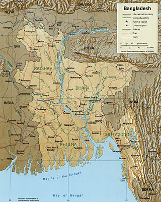
Feni is a coastal district situated in the south-east of Bangladesh, within the Chittagong Division. One of Bangladesh's smallest districts, it is strategically located along the Dhaka–Chittagong transportation corridor. Bordered by India to the north and the Bay of Bengal to the south, it serves as the sole entry point linking Chittagong, the country's primary port city, to the northern districts.

The International Joint Commission is a bi-national organization established by the governments of the United States and Canada under the Boundary Waters Treaty of 1909. Its responsibilities were expanded with the signing of the Great Lakes Water Quality Agreement of 1972. The commission deals with issues affecting the extensive waters and waterways along the Canada–United States border.

Teesta River is a 414 km (257 mi) long river that rises in the Pauhunri Mountain of eastern Himalayas, flows through the Indian states of Sikkim and West Bengal and subsequently enters Bangladesh through Rangpur division. In Bangladesh, it merges with Brahmaputra River which after meeting some other major rivers of the Bengal delta finally falls into the Bay of Bengal. It drains an area of 12,540 km2 (4,840 sq mi). In India, the Teesta flows through Mangan District, Gangtok District, Pakyong District, Kalimpong district, Darjeeling District, Jalpaiguri District, Cooch Behar districts and the cities of Rangpo, Jalpaiguri and Mekhliganj. In Bangladesh, it flows through Lalmonirhat District, Rangpur District, Kurigram District and Gaibandha District. It joins the Brahmaputra River at Phulchhari Upazila in Bangladesh. 305 km (190 mi) of the river lies in India and 109 km (68 mi) in Bangladesh. The Teesta is the largest river of Sikkim and second largest river of West Bengal after the Ganges.

The Meghna is one of the major rivers in Bangladesh, one of the three that form the Ganges Delta, the largest delta on earth, which fans out to the Bay of Bengal. A part of the Surma-Meghna River System, the Meghna is formed inside Bangladesh in Kishoreganj District above the town of Bhairab Bazar by the joining of the Surma and the Kushiyara, both of which originate in the hilly regions of eastern India as the Barak River. The Meghna meets its major tributary, the Padma, in Chandpur District. Other major tributaries of the Meghna include the Dhaleshwari, the Gumti, and the Feni. The Meghna empties into the Bay of Bengal in Bhola District via four principal mouths, named Tetulia (Ilsha), Shahbazpur, Hatia, and Bamni.

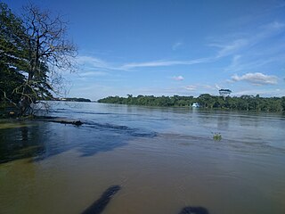
The Jamuna River is one of the three main rivers of Bangladesh. It is the lower stream of the Brahmaputra River, which originates in Tibet as Yarlung Tsangpo, before flowing through India and then southwest into Bangladesh. The Jamuna flows south and joins the Padma River (Pôdda), near Goalundo Ghat, before meeting the Meghna River near Chandpur. It then flows into the Bay of Bengal as the Meghna River.
The Feni is a river in southeastern Bangladesh and Tripura state of India. It is a trans-boundary river that is the subject of an ongoing dispute about water rights. The Feni River originates in South Tripura district and flows through Sabroom town and then enters Bangladesh. Muhuri River, also called Little Feni, from Noakhali District joins it near its mouth. The river is navigable by small boats as far as Ramgarh, about 80 kilometres (50 mi) upstream.

Atrai River flows in West Bengal and northern parts of Bangladesh.

The Kushiyara is a transboundary river in Bangladesh and Assam, India. It forms on the India-Bangladesh border as a branch of the Barak River, when the Barak separates into the Kushiyara and Surma. The waters that eventually form the Kushiyara originate in the uplands of the state of Assam and pick up tributaries from Nagaland and Manipur.
A transboundary river is a river that crosses at least one political border, either a border within a state or an international boundary. Bangladesh has the highest number of these rivers, with at least 58 major rivers that enter the country from the Republic of India, including two of the world's largest rivers, the Brahmaputra and the Ganges. The Naf River is the only river that flows via Bangladesh into Myanmar.

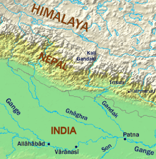
A long-standing dispute exists between India and Bangladesh over the appropriate allocation, and development, of the water resources of the Ganges River, which flows from northern India into Bangladesh. The issue had remained a subject of conflict for almost 35 years, with several bilateral agreements and rounds of talks failing to produce results.
The 'Joint River Commission was a bilateral working group established by India and Bangladesh in the Indo-Bangla Treaty of Friendship, Cooperation, and Peace that was signed on March 19, 1972, and came into being in November 1972. As per the treaty, the two nations established the commission to work for the common interests and sharing of water resources, irrigation, floods, and cyclones control. The studies and reports of the commission contributed directly to the efforts of both nations to resolve the dispute over the Sharing of Ganges Waters, facilitating bilateral agreements in 1975, 1978, and finally in 1996.

The Bangladesh–India border, known locally as the Radcliffe line (IB), is an international border running between the republics of Bangladesh and India that demarcates the six divisions of Bangladesh and the Indian states.

The Bhairab is a river in south-western Bangladesh, a distributary of the Ganges. It passes through Khulna, dividing the city into two parts. Bhairab River originates from Tengamari border of Meherpur District and passes through Jessore city. The river is approximately 160 kilometres (100 mi) long and 91 metres (300 ft) wide. Its average depth is 1.2 to 1.5 metres and with minimal water flow, it has plenty of silt.
Mathabhanga River is a transboundary river in India and Bangladesh.

The Dakatia is a river of Bangladesh and India. Its length is about 207 kilometres (129 mi). It enters Bangladesh from Tripura. After re-entering India from Comilla District, it joins the Meghna River at Chandpur Boro Station molehead.

The border between Namibia and South Africa is 967 kilometres (601 mi) long. It runs along the Orange River from its mouth on the Atlantic Ocean to the 20th meridian east, and then northwards along that meridian to the tripoint with Botswana at the Nossob River.

The Muhuri is a transnational river between India and Bangladesh. Rising in Tripura, it flows into Bangladesh where it merges with the Feni near the latter's mouth to the Bay of Bengal. The Muhuri is also known as the Little Feni.
The Feni River is a trans-boundary river located in Bangladesh, and the water rights have been a source of dispute between India and Bangladesh. It originates in the South Tripura district and flows through Sabroom town, entering Bangladesh. A Memorandum of Understanding (MoU) has been signed between Bangladesh and India, allowing India to withdraw 1.82 cubic feet per second of water from the Feni River. These two countries have signed seven bilateral documents concerning the water disputes.


