List of United States tornadoes from January to March 2022
Last updated
Tornado warnings and confirmations in January 2022
Tornado warnings and confirmations in February 2022
Tornado warnings and confirmations in March 2022
This page documents all tornadoes confirmed by various weather forecast offices of the National Weather Service in the United States from January to March 2022. In a recent 2000–2020 period, an average January features 32 tornadoes across the United States, the lowest month in a given year;[1] the broader 1991–2010 climatology is slightly higher at 35.[2] These tornadoes are commonly focused across the Southern United States due to their proximity to the unstable airmass and warm waters of the Gulf of Mexico,[1] as well as California in association with winter storms.[3] The year's first tornado, part of a broader outbreak on New Year's Day, caused EF2 damage on the Enhanced Fujita scale in Hopkinsville, Kentucky, a region hit particularly hard from one of the deadliest and largest December outbreaks on record.[4]
Overall, January was a relatively average month for tornadoes, with 37 confirmed. February saw only 11 tornadoes, which was below the average of 30. As spring approached, a dramatic upswing occurred in March as 234 tornadoes were confirmed in the United States, the most on record in that month and well above the average of 80. Several large tornado outbreaks that month helped to ramp up tornadic activity.
A short-lived but strong low-end EF2 tornado struck Hopkinsville. Several businesses and warehouses in town sustained minor to extensive damage to their roofs, walls, windows, and entryways. A few businesses, homes, and a church also sustained major roof damage, and some buildings sustained collapse of cinder block exterior walls. A gas station canopy and gas pumps were destroyed, and many trees were snapped or uprooted.[5]
In the Priceville area, a large barn was thrown 200–250yd (180–230m) to the southwest, and its foundation was moved 18in (0.46m) to the east. A smaller barn was thrown 60yd (55m) into the second story of a house, and a third barn had some of its roofing tossed up to 400yd (370m) away. Several trees were downed as well.[6]
A large pole barn had half of its roof removed and two garage doors blown in. Trees were snapped and uprooted as well. The tornado was originally rated EF1, but was downgraded to EF0 in the final report.[7][8]
This tornado came from the same circulation that produced the previous tornado. Two barns and a silo were completely destroyed. Two other silos sustained major damage, and additional barns were damaged as well. A house had minor damage to its porch, and numerous trees were snapped or uprooted.[9]
A brief multi-vortex tornado overturned an empty trailer, damaged the corner of a metal building, and twisted a flat metal roof. A trailer garage had its roof peeled off and a side wall collapsed. Another trailer was rotated, while a nearby garage door was crumpled inward.[10]
Many outbuildings and homes sustained mostly roof damage. An air conditioning unit was pushed partly off its foundation. Two power poles were bent, including one that was cracked at its base. A large garage suffered significant roof damage and had a wall buckled outward. Numerous trees were snapped or uprooted along the path.[12]
Over half a dozen barns were severely damaged or destroyed, including within Hiseville, with debris from these structures thrown as far as 400yd (370m) away. A large grain silo sustained damage to its side. Two homes suffered damage to their gutters, siding, and shingles. Trees were snapped, twisted, or uprooted, and gravestones at a cemetery in Hiseville were knocked over.[13]
Multiple outbuildings were destroyed, several homes sustained roof and window damage, and hundreds of trees were downed in the Union City community.[14]
A fire station had its garage doors blown out and had a portion of its roof and siding pulled off. Debris was thrown about 200yd (180m) downstream. Some other structures suffered minor roof damage. Trees were snapped or uprooted.[24]
January 3 event
List of confirmed tornadoes – Monday, January 3, 2022[note 1]
Several homes sustained roof, window, and siding damage. About a dozen trees were snapped or uprooted. At least two fences were blown over, and at least two sheds or outbuildings were rolled over or destroyed.[25]
Damage was intermittent, with the failure of a brick façade on an office building constituting the most severe damage. A few homes sustained roof damage, and several trees were downed.[30]
January 9 event
List of confirmed tornadoes – Sunday, January 9, 2022[note 1]
A retail building lost its roof and three walls, a post office suffered minor damage, and several trees were downed. Multiple homes were damaged, and a few vans were flipped in a church parking lot.[31]
About 30 homes were impacted in the Peason community, with 10 to 15 of those being heavily damaged or destroyed. The tornado peaked in intensity as it completely destroyed a mobile home, blowing its remnants up to 60 feet (18m) away into a tree line. Five people were in the mobile home at the time, all of whom were injured, some critically. Another injury occurred elsewhere, and outbuildings were destroyed at several farms along the path. At least one thousand trees were either snapped or uprooted along the path. This tornado caused $1.5 million in damage.[34]
A brief tornado caused considerable roof damage to a metal farm building and tossed a feed bin 150 feet (46m) away into a field. Another barn sustained minor damage.[35]
A mobile home sustained minor damage, and a few trees were downed.[37] In November 2023, this tornado was reanalyzed and upgraded to an EF1 based on multiple uprooted trees via Worldview satellite imagery.[38]
One home on Dog Island sustained significant damage to its porch and had its roof partially removed. Trees and power lines were damaged along the path.[39]
A waterspout came onshore near a marina where several boats were damaged, including one that was flipped. At least 35 homes were damaged as it struck a manufactured home community before dissipating.[40]
This tornado came from the same storm that produced the previous tornado. Four homes were damaged, two of which sustained major damage, with the other two sustaining minor damage. Several roofs and carports were either heavily damaged or destroyed.[41]
This strong tornado began as a waterspout over the Gulf of Mexico before moving inland. The tornado moved through three different mobile home communities in Iona, just southwest of Fort Myers, impacting at least 108 mobile homes. Of those, 30 were completely demolished, including some that were swept from their foundations, and 51 suffered major damage. Three people were injured. Mainly horticulture damage occurred in McGregor before the tornado dissipated near the Cape Coral Bridge. This tornado caused $10 million in damage.[42]
Two homes sustained roof damage and a few small trees were uprooted. Large branches were sheared off of several trees. A semi-truck was flipped on Interstate 75, injuring the driver.[44]
One home was shifted off its foundation with some of its walls collapsed, and numerous trees were downed. This was the first EF2 tornado produced by the western Alabama supercell.[46]
1 death – Trees were downed at EF0 intensity along the beginning of the tornado's path in Greene County near the town of Forkland, some of which fell onto homes. The tornado then crossed into Hale County and intensified as it downed hundreds of trees and damaged or destroyed several manufactured homes, including an unoccupied dwelling that rolled over and landed upside-down on top of a car. After the weakening slightly, the tornado reintensified as it approached and crossed SR 14 north of Sawyerville. Several homes were damaged and a double-wide manufactured home was destroyed, causing several injuries. A fish truck was overturned with its load of fish scattered across the road and two pick-up trucks were thrown into a nearby pond. The tornado reached its peak intensity of high-end EF2 to the northeast as it tore a double-wide manufactured home from its anchors and tossed it approximately 50 yards (46m) across a road, obliterating it. The one fatality from this tornado occurred here, along with two serious injuries. A home across the street sustained significant roof damage and had many windows blown out, and a manufactured home just to the south was split in half with one of the halves rolling away. Mainly tree damage occurred beyond this point before the tornado dissipated shortly after crossing SR 69. Eight people were injured in total. This was the second EF2 tornado produced by the western Alabama supercell.[47]
The third EF2 tornado produced by the western Alabama supercell moved through the Talladega National Forest, snapping or uprooting countless large trees. A home also sustained shingle damage and sheet metal was removed from the roof of a barn.[48]
This brief tornado lofted the roof of one outbuilding and blew metal paneling off of another. One house lost shingles and another was damaged by a fallen tree. Several other trees were uprooted as well.[50]
February 17 event
List of confirmed tornadoes – Thursday, February 17, 2022[note 1]
A mobile home sustained minor damage, an outdoor shed was overturned, and several trees were downed by this high-end EF1 tornado. A PDS tornado warning was issued for this storm.[51]
This tornado began in Lake Purdy, downing numerous trees as it moved northeast, including one tree that fell on a home. An apartment complex also sustained minor roof damage. It moved along the west side of Double Oak Mountain and towards Leeds, where many more trees and several power lines were downed. Several homes sustained minor roof and structural damage. A site-built home was damaged by a falling tree, and another falling tree completely destroyed a mobile home. The tornado weakened rapidly as it passed just east of Leeds and crossed into St. Clair County. A warehouse has some limited loss to roofing material before the tornado dissipated.[53]
February 22 event
List of confirmed tornadoes – Tuesday, February 22, 2022[note 1]
Sections of roofing were removed from hog barns, and several trees and tree limbs were downed. This tornado intersected the path of the 2021 Western Kentucky tornado from two months prior.[55]
This tornado passed just south of Garden Grove, ripping the roof off of a house and damaging or destroying several outbuildings. The tornado also passed near Humeston, producing additional damage to outbuildings, snapping power poles, and downing numerous trees.[61]
1 death – This low-end EF3 tornado touched down after the EF2 tornado near Derby dissipated. Multiple homes were severely damaged or destroyed, a small music venue had its roof torn off, and gas leaks were reported. Barns and outbuildings were also completely destroyed, along with the Pin Oak Marsh Lodge Educational Center near Chariton. The tornado moved directly through Red Haw State Park, where small structures were destroyed at a campground, boat docks were destroyed, and one person was killed when an RV camper was thrown. Many large trees and power poles were snapped along the path, and one person was injured.[64]
A strong tornado touched down near Allerton and clipped the southeastern edge of town, where a manufactured home had its roof torn off, power poles were snapped, and trees were downed. A concession stand was completely destroyed at the local baseball field, and two frozen turkeys that originated at a residence nearly a half-mile away were found at that location. A machine shed was destroyed near Corydon before the tornado dissipated.[65]
This was a satellite tornado of the EF3 Chariton tornado. It looped around that tornado before being absorbed by the larger circulation, causing little to no damage.[66]
This large multiple-vortex tornado touched down three minutes after the EF4tornado dissipated. Trees and power poles were snapped, and outbuildings were destroyed along the path.[67]
This was the fifth tornado from the Winterset supercell. A house had its roof torn off, trees were downed, outbuildings were damaged, and vehicles were flipped.[68]
This was the final tornado from the Winterset supercell. Several power poles were snapped, and trees and outbuildings were damaged before the tornado moved into the northwest side of Vinton. In town, the tornado damaged many structures including mobile homes, homes, and buildings at an industrial park. The tornado continued to the northeast of Vinton where it damaged trees and outbuildings before dissipating.[69]
One farm home had its garage roof and porch awning ripped off. Several barns and other farm buildings sustained significant damage, and a semi-truck on I-55 was flipped.[75]
A few homes and outbuildings were damaged, and large sliding doors on a volunteer fire department building were blown in. Many trees were downed, one of which landed on a house.[80]
Several homes, barns, and sheds were damaged or destroyed in Sage as a result of this low-end EF2 tornado. One horse barn was destroyed, a modular home was torn apart, and one person was injured when a mobile home was rolled. A metal storage container where people were taking shelter was rolled as well, injuring all five of them, one seriously. Many large trees were snapped or uprooted along the path, and power lines were downed.[84]
A barn was destroyed, a school sustained roof damage, and a home sustained roof and chimney damage. Sports equipment in a field was damaged, trees were downed, and tree limbs were broken.[88]
March 9 event
List of confirmed tornadoes – Wednesday, March 9, 2022[note 1]
A brief tornado embedded in a larger area of straight-line wind damage caused minor roof damage to three houses and damaged several sheds and storage buildings. A small flag pole was bent to the ground, a power line was downed, and numerous trees were either snapped or uprooted.[91]
A brief tornado touched down in a gravel parking lot, tipping over a boat on a trailer and tossing a tram about 100 yards (91 metres), destroying the back of it. Debris was thrown across a golf course as well.[93]
A short-lived tornado, spawned by the same supercell as the Chipley tornado, caused substantial roof damage to large barns and outbuildings and tossed several smaller outbuildings. A couple of trees were uprooted as well.[95]
Several mobiles homes were shifted off their foundations and sustained significant roof damage, a garage was severely damage with debris strewn downwind, and windows were broken at a police station. An apartment complex sustained minor damage, and a shed was slightly shifted. A tree and a utility pole were snapped as well.[99]
March 11 event
List of confirmed tornadoes – Friday, March 11, 2022[note 1]
In Dunnellon, a billboard was knocked down and siding was peeled from a professional building. On the south and east sides of Ocala, numerous homes and an apartment building were damaged, trees were uprooted or snapped, and power lines were downed.[102]
A waterspout moved onshore and lifted a boat from a dock, and snapped or uprooted trees, some of which fell on and damaged homes. A car was shifted slightly near the end of the path. The cost of damage was conservatively estimated at $50,000.[103]
Several metal barns were heavily damaged, a triple-wide manufactured building was shifted off its cement block foundation, and one home sustained roof and window damage. Numerous trees were downed along the path.[107]
A very brief tornado snapped a tree, caused damage to the roof of a home, and destroyed a well pump. The garage door of a second home was blown out, and a utility building lost metal siding. Some pieces of heavy equipment moved as well.[108]
March 16 event
List of confirmed tornadoes – Wednesday, March 16, 2022[note 1]
A house lost part of its roof and another house lost shingles. One mobile home was destroyed and another sustained roof damage. Trees were snapped, twisted, and uprooted as well.[110]
A brief tornado snapped numerous trees in a wooded area in the northern part of Eucheeanna and did not affect any structures. A tornado debris signature was detected on radar.[111]
Numerous homes were damaged in Panama City, some of which had large sections of their roofs torn off or were shifted off their foundations. One house was moved 4 feet (1.2m) off its foundation, a church sustained roof damage, and fencing was blown over. Many trees were downed and power poles were snapped, while sheds and carports were destroyed.[113]
Southwest of Salem, a house and a barn sustained major roof damage and a carport was thrown several hundred feet. Another house sustained minor damage and several outbuildings were also damaged, while dozens of trees were uprooted or snapped. In Salem, a large tree was uprooted, another was damaged, and two businesses sustained damage to their roofs and exteriors.[114]
One house suffered major roof damage and another suffered minor roof damage. A barn lost its roof, with debris impaled into the ground, and other barns were damaged. Construction materials were thrown into a field, and trees were damaged.[116]
The tornado, which had a skipping path, was produced by the same supercell as the Breckinridge County tornado. About a dozen homes in West Point had roof and siding damage, and trees were downed. A shed lost its roof, which landed on a nearby truck, and a piece of the roof was impaled on a stop sign. The tornado was captured by a home security camera.[117]
This long-lived and intense tornado touched down after the previous tornado dissipated. It impacted Jacksboro, with the most severe damage occurring at and around Jacksboro Elementary School. Many homes in town sustained loss of their roofs and exterior walls, and a few poorly built homes collapsed. The elementary school was heavily damaged and had the roof of its gymnasium ripped off, also sustaining the collapse of an exterior wall, while nearby flag poles were bent and cars were overturned in the parking lot. The tornado also struck Jacksboro High School, ripping part of its roof off, damaging the press box at the stadium, and bending the field goal and a light pole. An animal shelter in Jacksboro was also destroyed. Significant damage also occurred in areas outside of town, as a 400-foot-tall guyed communications tower was toppled, metal high-tension truss towers were collapsed, and four large wind turbines were destroyed. Major tree damage occurred along the path, while sheds and outbuildings were damaged or destroyed. Approximately 90 homes were damaged or destroyed by this tornado, and 9 people were injured.[120]
This was the third tornado from the Jacksboro supercell. Multiple small barns and outbuildings were damaged, including one outbuilding that had its roof ripped off and multiple walls collapsed. Several houses sustained roof damage, and a partially full water tank was blown a considerable distance from where it originated.[121]
This was the fourth tornado from the Jacksboro supercell. Multiple site-built and manufactured homes were impacted, several of which had their roofs lifted and walls collapsed. One manufactured home was completely destroyed, and three people were injured.[122]
This was the fifth tornado from the Jacksboro supercell. Several sheds and small barns were damaged, and a manufactured home was separated from its undercarriage. A nearby house suffered damage to its roof and several windows, and tree damage occurred as well. One person was injured.[124]
This tornado came from the same supercell that produced the Wise County EF0 tornado. In Era, minor damage to trees and the canopy of a gas station occurred. Elsewhere, homes sustained major roof damage and trees were snapped. A horse trailer was also flipped, a metal implement shed, and other outbuildings were destroyed, and a steel water tank was knocked over. The tornado struck Gainesville near the end of its path, where fencing was downed, and some businesses had roofing blown off. A metal commercial building in town had two roll-up doors blown out and its roof uplifted. The tornado caused minor damage at a cattle yard before it dissipated at the north edge of Gainesville.[126]
A floating marina cover was thrown about 50 yards (46m) and destroyed. Several boats and one tree were also damaged. Unusually, this tornado formed in the outflow of a nearby storm.[127]
Metal panels were ripped from two barns, one of which had its entire roof and part of an exterior wall ripped off. A house had most of its roof torn off, and another home sustained more minor roof damage. A large RV was tossed about 100 feet (30m) and destroyed, and a four-person ATV was thrown as well. Many large trees were snapped or uprooted, and an old wooden barn was pushed over and twisted as well. The tornado damaged a house, an old RV, and some trees in the small community Stairtown at the end of its path. This was the first of eight tornadoes produced by this supercell.[129]
Several homes sustained significant roof damage, farm outbuildings were damaged or destroyed, and a large metal building had its doors blown out. A stone company also had its large doors blown out, a small metal building was demolished, a utility pole snapped at its base, and multiple trailers were rolled and destroyed. The tornado entered the south edge of Prairie Dell before dissipating, where trees and tree limbs were downed, and some metal fencing and a gate was blown over. This tornado intersected the path of the 1997 Jarrell F5 tornado.[130]
A damaging high-end EF2 tornado impacted numerous structures as it touched down in the Austin suburb of Round Rock. Many homes were damaged as the tornado moved through multiple neighborhoods, some of which sustained roof and exterior wall loss. Several businesses and warehouses had broken windows, exterior façade damage, roofing blown off, and HVAC units torn off. Windows were shattered at the Kalahari indoor water park and hotel, cars were flipped in parking lots, and semi-trailers were overturned. A couple of homes that were under construction collapsed as the tornado exited Round Rock and impacted the northern edge of Hutto, then continued to the northeast and passed south of Granger. A few homes, outbuildings, and metal storage unit buildings were heavily damaged or destroyed in this area, including one poorly constructed home that was swept clean from its foundation. An older home on piers sustained total loss of its roof and exterior walls, with some interior walls destroyed and blown away as well. Trees and power poles were downed near Bartlett and in Vilas before the tornado dissipated. Sixteen people were injured.[131]
1 death – After the Gainesville EF1 tornado dissipated, this strong tornado touched down in Sherwood Shores, where numerous mobile homes were flipped or destroyed, a couple of site-built homes were also significantly damaged, and one person was killed. One house was shifted off of its foundation, while another lost a large section of its roof, along with a second-floor exterior wall. A shipping container was rolled, and outbuildings were damaged or destroyed as well. A total of 53 structures were destroyed, 27 had major damage, while 105 others sustained lesser damage in the Sherwood Shores area. The tornado crossed Lake Texoma into Oklahoma and struck the Buncombe Creek Marina, where many boats, docks, RVs, and mobile homes were thrown and destroyed. Some frame homes and metal warehouse structures also sustained major structural damage, numerous trees were snapped, and power lines were downed. Less severe damage to trees and outbuildings occurred at the end of the path. Eleven people were injured.[132]
This tornado touched south of Kingston after the Sherwood Shores EF2 tornado dissipated. It moved to the northeast, causing damage to trees and structures along its path. A house near the beginning of the path had extensive roof damage. As the tornado moved through the east edge of Kingston, multiple homes sustained considerable damage, along with some metal buildings that had roof and wall panels pulled off. Additional damage to homes, outbuildings, and trees continued past Kington as the tornado approached and struck Little City, where mostly minor tree and structure damage occurred before it dissipated.[134]
Numerous structures were damaged or destroyed by this high-end EF2 tornado, including within the southern and eastern fringes of Elgin. The tornado destroyed multiple outbuildings and manufactured homes, damaged many frame homes, snapped power poles and trees, and toppled metal truss electrical transmission towers. Two houses had their top floors destroyed, and a large metal-framed warehouse building also sustained major structural damage, including a collapsed wall and buckled roof purlins. The tornado was caught on video as it crossed US 290 and rolled a moving pickup truck onto its side, spun it around 360 degrees, and rolled it back upright, allowing the driver to continue driving down the road. In total, 109 residences and a business were damaged; 32 of those residences sustained major damage, while 20 residences and the business were destroyed. Three people were injured in a manufactured home that was rolled.[135]
Two barns were severely damaged, with one losing most of its roof. A home lost most of its roof shingles, and two wooden power poles were snapped. A tree was also snapped in half.[140]
The roof of a barn was blown off, and the roofs of several metal structures and outbuildings were damaged. A fence was blown down, tree branches were broken, and the cross on the steeple of a church was bent. This was the second tornado produced by the Kingsbury supercell.[142]
The roofs were ripped from a small barn and two manufactured homes. Several trees, a few metal shelters, and a carport were also damaged. A large, anchored farm outbuilding was wrapped around a tree.[143]
The roofs of a couple homes, a garage door, and an apartment complex were damaged in town. This was the third tornado produced by the Kingsbury supercell.[144]
A small aluminum shed was destroyed at an aquatic facility. A few trees and power lines were downed as well. This was the fourth tornado produced by the Kingsbury supercell.[145]
A home was pushed off its block foundation and had its roof damaged. The trunks of trees were snapped as well. This was the fifth tornado produced by the Kingsbury supercell.[146]
Several homes and a few businesses sustained considerable damage in Madisonville, including one business that sustained collapse of its brick facade. Several power poles were snapped in town as well. This was the sixth tornado produced by the Kingsbury supercell.[147]
1 death – This strong tornado first touched down in the small community of Mapleton, where a house had its roof torn off, outbuildings were destroyed, and trees were downed. Continuing to the northeast, the tornado snapped or uprooted numerous large trees and destroyed a couple of mobile homes. Three people were seriously injured when they were thrown from one of the mobile homes into an adjacent field. The tornado struck the north edge of Crockett before dissipating, where multiple homes were heavily damaged, including a few that had some roof and exterior wall loss. A convenience store was destroyed in this area as well. 10 people were injured.[148]
A long-tracked, strong tornado caused high-end EF2 damage along its path. Multiple frame homes had their roofs torn off, and a few sustained exterior wall loss as well, while a poorly anchored guest house was swept completely away behind a residence. One house was struck by a projectile, leaving a large hole in the side of the structure, while the entire second floor of a two-story home was ripped off and destroyed. Multiple RVs were thrown into the water at Lake O’ the Pines, and a bait shop had its roof torn off at that location. Numerous manufactured homes were completely destroyed, along with outbuildings and a metal storage building. Countless trees were snapped along the path, and seven people were injured.[149]
A large and strong tornado snapped or uprooted many thousands of trees along its path. The tornado impacted the western and northern outskirts of Cushing, where approximately 50 structures were damaged, including a church that was destroyed and multiple homes that sustained partial to complete roof loss. Elsewhere along the path, mobile homes were thrown and destroyed, and frame homes sustained significant damage. Metal truss electrical transmission towers were blown over, and numerous outbuildings were damaged or destroyed along the path. This was the seventh tornado produced by the Kingsbury supercell.[150]
This was the eighth and final tornado produced by the Kingsbury supercell. Multiple homes were significantly damaged, including one that sustained high-end EF2 damage, losing most of its roof and several exterior walls. Over 1,000 trees were snapped, outbuildings were damaged or destroyed, farming equipment was overturned, and one person was injured.[153][154]
This tornado impacted the town of Edwards, where several trees were downed and a few landed on structures. Many additional trees were downed elsewhere along the path, three outbuildings sustained significant roof damage, and homes and other outbuildings sustained damage from falling trees. One tree fell through the roof and wall of a house, causing significant damage.[162]
Several manufactured homes, outbuildings, houses, and a church suffered loss of roofing material. The most severe damage occurred to one home that had its entire roof removed. Two manufactured homes were shifted off their foundations, one of which was heavily damaged. Numerous trees were snapped or uprooted, and some power poles were snapped.[164]
A strong tornado tracked through remote forested areas, where numerous large trees were snapped or uprooted along a wide swath. The tornado was accompanied by strong inflow winds up to 80mph (130km/h) which downed additional trees and utility poles.[165][166]
The roof was ripped off the back half of a manufactured home, and siding was ripped from its sides. A detached carport at an adjacent home was destroyed and blown across the yard. A large section of roofing material was stripped from another manufactured home. Trees were snapped and uprooted as well.[170]
A high-end EF1 tornado caused considerable damage in Goodman, where extensive tree damage occurred, power poles were snapped, an apartment building had part of its roof torn off, and some outbuilding structures were destroyed. Significant roof damage was inflicted to multiple structures, including several buildings on the campus of Holmes Community College. A gas station was heavily damaged, with the canopy being destroyed and the convenience store losing its metal roofing. In other areas outside of town, homes sustained minor damage, a shed was destroyed, a travel trailer was lofted across a roadway, fencing and a hunting stand was blown over, and trees were snapped or uprooted.[180][181]
A strong tornado snapped or uprooted numerous large trees in the Damascus area, and entire stands of trees were mowed down in some areas. One tree fell on a mobile home, destroying the structure. A frame home was destroyed with only a few walls left partially standing, and a mobile home was obliterated after it was ripped from its anchors and thrown 100 yards (91m) through the air into trees. A horse trailer and hay bales were also thrown, and outbuildings were damaged or destroyed, including one that was completely destroyed with its debris strewn downwind.[188]
A few homes sustained minor damage, many trees were downed, and several power poles were snapped. Minor roof damage occurred to buildings at a livestock facility. One person was injured in Clay County while trying to run from a vehicle to a house.[189][190]
A manufactured home was destroyed after being lifted and rolled, and sheet metal debris from the structure was wrapped around trees. Numerous large trees were snapped or uprooted, a power pole was downed, and a house sustained minor roof damage as well.[193] In November 2023, this tornado was reanalyzed and had its path length adjusted from 2.45mi (3.94km) to 4.33mi (6.97km).[194]
Several trees were damaged, two of which fell on structures. The attached garage at one house had an exterior wall blown in, allowing winds to uplift a portion of the roof of home. Power lines were downed as well.[195]
A manufactured home was shifted off its foundation, with its carport and a nearby shed being heavily damaged. The metal roof was lifted off the back of a nearby house, causing tornadic winds to blow out the front windows, walls, and part of the roof structure. Metal from the house was wrapped around trees. Numerous trees were snapped or uprooted along the path as well.[200] In November 2023, this tornado was reanalyzed and had its path length adjusted from 0.19mi (0.31km) to 3.05mi (4.91km).[201]
The roofs of a barn and business in town were damaged. Numerous trees were uprooted, at least two of which fell on a permanent house and a manufactured home.[202][203]
This low-end EF1 tornado touched down along US 190 on the north shore of Lake Pontchartrain and moved northeast, north of Lacombe. Several homes sustained minor roof damage, a shed was destroyed, and dozens of trees were downed.[207]
Near Summerdale, a storage building sustained damage to its walls and had roofing material removed. Trees were snapped, gravel was blown off a road surface, and irrigation pivots were flipped over. Two homes sustained minor damage as the tornado continued north of town. A few businesses sustained minor roof damage and tree limbs were downed in Robertsdale before the tornado dissipated, and a shed was overturned in town as well.[209]
Hundreds of trees were downed, including one that fell on a mobile home. A site-built home sustained major roof and exterior wall damage, and a manufactured home was torn in two and rolled off its foundation. Another home had its metal roofing peeled off, and an outbuilding was destroyed. Three people sustained minor injuries.[215]
A two-story home was shifted off its foundation and had its roof torn off, and a modular home lost half of its roof. Numerous trees were snapped or uprooted along the path.[217]
Dozens of trees were downed and a small barn was completely destroyed, while a second barn sustained moderate damage. A house suffered roof and siding damage, and a double-wide manufactured home sustained severe damage to its exterior.[218]
A tornado embedded within a larger area of damaging straight-line winds damaged outbuildings and farm equipment. One outbuilding was destroyed at the end of path.[219]
A brief tornado touched down in the eastern part of St. Joseph. A school building had part of its roof torn off, a house sustained significant structural damage, and a few trees and tree limbs were downed at a local park.[220]
This strong tornado developed just southwest of the Northwest Arkansas Mall in the northern part of Fayetteville, near Johnson. An automotive business was destroyed, while other businesses and a few homes sustained minor to moderate damage as the tornado passed near the mall. A van was rolled and a cell tower was blown over before the tornado entered Springdale, where vehicles were flipped and dozens of homes were damaged, some significantly with partial to total roof loss. The most intense damage occurred at George Elementary School, which had part of its roof peeled back and sustained total collapse of its metal gymnasium building, and at a large Nilfisk distribution warehouse that was largely flattened, with both areas earning a low-end EF3 rating. A hangar at Springdale Municipal Airport was destroyed, and other buildings were damaged on the east side of the airport. A couple of businesses were heavily damaged, and additional homes sustained minor roof damage before the tornado dissipated. Many trees and power poles were snapped along the path, and debris from Springdale was blown northward into Benton County. Seven people were injured.[221]
A brief tornado embedded within a larger area of straight-line winds caused significant damage to the top floor of a house, moved several trailers, and destroyed a shed. Another home sustained collapse of its porte-cochère, and the attached garage had its roof torn off. Poles were bent at a basketball court, and a few trees were downed.[222]
Several houses, outbuildings, and a manufactured home sustained minor damage in Adamson. Trees were snapped or uprooted, and multiple trailers were rolled.[223]
Metal panels were ripped off a barn and thrown up to 300yd (270m) away. The roof of another barn and a home were damaged, and trees were downed along the path.[224]
Ten homes were damaged near Toledo Bend Reservoir, several of which sustained significant roof damage. A couple more homes were damaged by falling trees, while garages and boat houses were severely damaged as well.[227]
A brief tornado heavily damaged the side of an outbuilding and snapped or uprooted many trees. The tornado may have continued into an inaccessible area.[233]
In Girard, power lines were downed, and a couple sheds were damaged. Several homes sustained roof and fascia damage north of Rayville, and a couple sheds were destroyed. Numerous trees were downed along the path.[237]
Several homes sustained minor roof and fascia damage, a mobile home was damaged, and a shed was destroyed. Several trees were downed, with one large tree falling on a home.[239]
In Tallulah, a school suffered considerable damage and lost a large portion of its roof, homes sustained varying degrees of roof damage, and several mobile homes were damaged, one of which was significantly damaged after being pushed off its blocks. A brick arch was destroyed at a cemetery, and metal buildings were heavily damaged at a baseball field in town. Outside of Tallulah, several irrigation pivots were overturned and a tractor shed was demolished. In Mississippi, some structures sustained damage to metal roofs and carports. Large trees, power poles, and fences were downed along the path as well, including one tree that fell through a house. The tornado crossed the Mississippi/Louisiana state line three times.[240][241][242][243]
Several houses sustained exterior and roof damage, including the collapse of their chimneys, carports, and metal siding. A small farm outbuilding suffered roof damage, while trees and wooden power poles were snapped.[244]
Several houses and businesses were damaged in Cleveland, including a few structures that lost portions of their roofs. A car dealership and hair salon had their windows shattered, and glass from the salon injured one person. A gas station canopy and metal outbuilding were also damaged.[245]
Numerous trees were snapped or uprooted, some of which were downed onto a manufactured home. Homes, outbuildings, and barns sustained roof damage. One shed was completely demolished. The tornado crossed the damage path of a tornado just a week prior.[248]
A large tornado overturned a center pivot irrigation system and snapped or uprooted numerous trees. Two homes had portions of their roofs removed. A manufactured home was demolished, with a man inside being thrown and injured. Several power poles were downed, and a small shed and a grain storage bin were damaged. A metal building had a large roll-up door blown inward, and a portion of the back of the building was blown outward.[249][250]
Numerous trees were snapped or uprooted as the tornado passed through the community of Spring Ridge, including one large tree that fell through a house.[251]
Many trees, power poles, and power lines were downed in Pope, including a tree that fell onto a home. Large trees were snapped elsewhere, a mobile home was severely damaged, and several frame homes sustained extensive roof and siding damage.[252]
This tornado was broadcast live on local TV news by weather cameras as it moved through parts of downtown Jackson. About a dozen homes had minor to moderate damage, and several businesses sustained roof damage. Numerous trees, fences, and power lines were downed. One person was injured.[253]
A tornado tracked along a discontinuous path, causing sporadic tree and house damage. Falling trees caused additional damage to structures. Multiple utility lines were downed. A large portion of the outfield wall to the Smith–Wills Stadium was downed.[254][255]
Twenty power poles were destroyed, several homes and outbuildings were damaged, and a manufactured home was shifted. Numerous trees were snapped or uprooted.[259]
A large and significant tornado destroyed multiple sheds and snapped or uprooted thousands of large trees along its path. Several homes and a church had damage to their roofs, including a few structures that sustained considerable roof damage.[260][261]
At least a dozen homes and a church had shingles torn off in Carmi, a sign was blown over, and a storage shed at the edge of town was destroyed. Additional damage occurred outside of town as well, where a few sheds and outbuildings were damaged or destroyed, a couple of homes sustained minor roof damage, and a small boat was blown into a pond. Trees and power poles and lines were downed along the path as well.[263]
Trees and tree limbs were downed in Roseland. Several homes and mobile homes were significantly damaged outside of town, including one double-wide mobile home that was lifted off of its blocks and had its roof torn off. Trees were snapped or uprooted, outbuildings were destroyed, and a wooden post was speared through the windshield of a vehicle.[264]
Several homes sustained roof damage near the beginning of the path, a few of which were heavily damaged. At a manufacturing facility, the exterior wall of a large metal building was peeled off its frame, and several large roll-up doors were blown in. Several metal power poles were bent at that location, and several businesses were damaged farther along the path. The tornado then entered Jackson before dissipating, where Jackson-Madison County General Hospital was damaged, the roof was blown off a nearby nursing home, and a light pole was damaged at a baseball field. Numerous trees were snapped or uprooted along the path.[265]
Several homes sustained roof and window damage, and a metal building in town was damaged as well. Many trees were downed in and around Huntingdon.[268]
A weak tornado removed a portion of a gas station canopy in town, caused minor tree damage, and downed a sign. A portion of a metal roof was blown off a structure as well.[272][273]
A home had a small section of its metal roofing removed, and a second house sustained minor shingle damage. Trees were damaged and uprooted as well.[275]
A majority of the wooden fence around the Clarkdale Attendance Center softball field was knocked down. A small portion of metal roofing was lifted off a building, and the awning over the dugout was ripped off, causing the structure to fail. A section of bleachers were damaged, and a small metal building was lifted off its foundation. Several trees were snapped as well. This same area was hit by an EF2 tornado the following month on April 13, 2022.[276][277]
A high-end EF2 tornado tore a large portion of the roof from a house, and damaged or destroyed several metal storage buildings and outbuildings. Concrete pillars from one outbuilding, which were rebared into a steel plate, were pulled from the ground and one was missing. A mobile home was rolled and destroyed; two people inside were thrown into a wooded area and injured. Another mobile home sustained minor roof damage, while chicken houses were damaged, and numerous trees and power poles were snapped.[278]
Numerous large trees were snapped or uprooted, several homes sustained roof damage, and an RV was rolled. Several outbuildings suffered extensive damage as well.[279][280]
A tornado began just south of the previous one, causing significant structural damage to the roof and exterior wall of a manufactured home. A shed had tin ripped off and its cinder block walls were shifted. Numerous trees were snapped or uprooted.[282]
A strong tornado struck McLain, where homes had carports and metal roofing torn off, one of which lost most of its roof. A church sustained roof damage, and a single-story apartment building in town had its entire roof ripped off and was partially destroyed, though the structure was poorly-constructed. Some chicken houses were destroyed and sheds were significantly damaged, with sheet metal wrapped around trees. Numerous large trees were snapped or uprooted, some of which fell on houses, and a manufactured home was rolled onto its side.[285][286]
The exterior cinder-block wall of a small car wash was partially collapsed. Numerous trees were snapped or uprooted, and other structures in town sustained minor roof damage.[287]
Swaths of trees were snapped or uprooted by this tornado, including multiple trees that were downed in the northern part Livingston shortly before the tornado dissipated.[288]
A brief tornado caused minor roof damage to homes and snapped or uprooted several trees. A medium-sized storage building lost half its roofing material.[289]
A large tornado downed numerous trees, some of which fell on houses. Homes, barns, and outbuildings were damaged, and some chicken houses were damaged or destroyed.[290][291]
Many trees were snapped or uprooted, some of which damaged manufactured homes upon falling. Two manufactured homes were destroyed, and additional houses and farm buildings were damaged.[292]
Multiple trees and power lines were downed, and a few homes sustained roof damage in Choctaw County. The most intense damage occurred as the tornado crossed the Tombigbee River into southwestern parts of Marengo County, causing significant damage near Nanafalia. Hundreds of trees were snapped or uprooted, and a manufactured home was completely destroyed, with the undercarriage rolled at least 30 yards (27m) from its foundation. A brick home sustained roof damage due to winds and a falling tree, and another house lost large portions of its roof and exterior walls. More homes sustained minor damage, and an abandoned manufactured home was rolled before the tornado dissipated.[293][294][295][296] In November 2023, this tornado was reanalyzed and had its path length in Choctaw County adjusted from 18.27mi (29.40km) to 20.16mi (32.44km) due to notable tree damage and defoliation of vegetation noted on Sentinel satellite imagery.[297]
Multiple mobile homes had undercarriage and roof damage and were shifted off their foundations, but none of the anchor straps broke. There was additional minor roof damage to a well-built home and damage to a nearby barn, along with two uprooted trees.[300]
The most intense damage from this large and strong tornado occurred in remote forested areas, where tens of thousands of large trees were snapped and uprooted along a wide swath, with some trunks left partially debarked. Camper units were rolled or destroyed at a hunting club, and several homes were damaged by tornadic winds and falling trees. The tornado weakened as it approached and struck the University of Montevallo campus, where trees were downed and dormitory building roofs were damaged before tornado dissipated. Two people were injured.[301][302][303]
This tornado caused considerable damage in the downtown part of Faunsdale. The roof and an exterior wall were removed from the Faunsdale Bar and Grill, tin panels were peeled back from the roof of a metal warehouse, and other structures sustained partial roof removal as well. A couple of outbuilding structures were destroyed, and several trees and tree limbs were downed.[305]
A large metal building structure lost most of its roof and some exterior metal walls, and many trees were snapped or uprooted. The tornado was associated with a broader swath of 90–95mph (145–155km/h) straight-line winds.[308]
Several power poles were snapped, a carport was destroyed, a street sign was downed, and several homes and businesses sustained roof damage in Theodore. Several trees were snapped or uprooted as well.[312]
Several outbuildings were destroyed, numerous homes suffered considerable roof damage, and numerous trees were snapped or uprooted by this high-end EF1 tornado. Several hundred feet of pasture fencing were destroyed at a power substation, and a barn lost a majority of its outer walls.[316]
This tornado touched down in Lowndesboro, where a building at the Lowndes Academy lost its metal roof, numerous historic homes in town sustained minor roof damage, and one sustained more significant roof removal due to its front porch being uplifted. Dozens of trees were snapped or uprooted, and minor damage occurred outside of town before the tornado dissipated.[317]
A tornado began over the Escambia Bay Bridge, overturning a semi-truck and injuring two occupants. It moved onshore from Escambia Bay into Avalon, causing widespread tree damage. A personal weather station recorded a peak gust of 97mph (156km/h), and multiple homes suffered roof and window damage. Street signs were downed, and some siding and roofing material was removed from the Avalon Utilities building as well.[320]
2 deaths – A strong tornado touched down near Wausau and passed to the northwest of Alford before dissipating, causing severe damage along its path. Multiple anchored single and double-wide mobile homes were thrown and obliterated, with debris scattered long distances through fields. Two people were killed in the destruction of a double-wide mobile home, and another person was injured after being thrown from a single-wide mobile home into a wooded area. The most intense damage was inflicted to a frame home that was completely swept away with only its block foundation remaining, and to a well-built brick home that had its roof torn off and exterior walls collapsed. Other residences were damaged to a lesser degree, while barns and outbuildings were destroyed and farming equipment was damaged. Numerous trees were snapped or uprooted along the path, projectiles were embedded into the ground, vehicles were moved and damaged, and a generator was ripped from its anchoring and thrown across a field. In addition to the two fatalities, three people were injured.[321][322]
A strong multiple-vortex tornado snapped or uprooted hundreds of large hardwood trees in a wooded area. Two barns were destroyed, and metal roofing was ripped from a small outbuilding as well.[323]
A brick home was shifted off its foundation, with several of its exterior walls blown out and more than half of its roof removed. Tin roofing was ripped from an agricultural building, and a chicken farm was significantly damaged.[324][325]
A tornado demolished three barns, one of which was thrown across a yard, with a piece of its lumber impaled into the hood of a Jeep. Wood from a second barn was thrown through a truck windshield, shattering the window and sending glass into the eye of a passenger. Multiple homes and outbuildings in Lairdsville suffered damage, a butcher shop was also damaged, and hundreds of trees were downed.[327]
A few homes and an apartment complex lost shingles and sustained minor exterior damage. A CVS pharmacy also sustained minor damage, and trees were uprooted or snapped, including one tree that fell on a parked vehicle.[330]
The tornado outbreak of October 17–19, 2007 was a widespread tornado outbreak that took place across much of the eastern half of North America starting on October 17, 2007, and continuing into the early hours of October 19. The outbreak was also responsible for five deaths; three in Michigan and two in Missouri, plus many injuries. At least 64 tornadoes were confirmed including 16 on October 17 across six states including Texas, Oklahoma, Arkansas, Louisiana, Mississippi and Missouri with wind damage reported in Oklahoma, Kansas, Illinois, Iowa, Arkansas and Mississippi. On October 18, at least 48 tornadoes were confirmed across eight states including Florida, Alabama, Mississippi, Tennessee, Kentucky, Illinois, Indiana and Michigan, plus widespread straight line wind damage. Until 2010, this event held the record for largest tornado outbreak ever recorded in the month of October according to NOAA.
A significant severe weather and tornado outbreak affected the Southern United States between December 16–17, 2019. Discrete supercells developed in the early morning on December 16 and moved northeast, spawning multiple strong, long-tracked tornadoes in cities such as Alexandria and in Laurel before congealing into an eastward-moving squall line. During the outbreak, the National Weather Service issued several PDS tornado warnings as well as a rare tornado emergency for Alexandria. In addition to this, the Storm Prediction Center issued six tornado watches for the outbreak. The event happened to take place on the same date of another outbreak in a similar area 19 years earlier.
The tornado outbreak of January 10–11, 2020 was a two-day severe weather event stretching from the South-Central Plains eastward into the Southeast United States. An eastward-moving shortwave trough tracked across the continental United States through that two-day period, combining with abundant moisture, instability, and wind shear to promote the formation of a long-lived squall line. Hundreds of damaging wind reports were received, and 80 tornadoes occurred within this line, making it the third largest January tornado outbreak on record. Three tornadoes—an EF1 in eastern Texas, an EF2 in northern Louisiana, and an EF2 in western Alabama—led to a total of seven deaths, all in mobile homes. There were five other storm related deaths, including two due to icy roads in Lubbock, Texas, one due to drowning in Oklahoma, and one due to icy roads in Iowa. The system also brought a monthly record high temperature to Boston and Bridgeport. Extensive damage and several other injuries occurred as well. The severe weather event was notable in that it was forecast well in advance, with the Storm Prediction Center first highlighting the risk area a full week beforehand. Total damage from the event reached $1.1 billion according to the National Centers for Environmental Information.
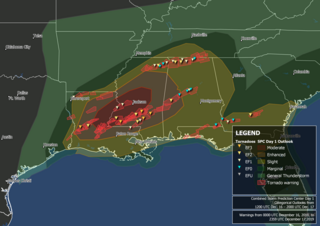
A large tornado outbreak struck the Southern region of the United States on March 21–22, 2022, before transitioning to the Eastern United States on March 23. The outbreak started with numerous supercell thunderstorms and severe squall lines developing in central Texas and southern Oklahoma, prompting the issuance of numerous tornado warnings, including multiple PDS tornado warnings. An EF3 tornado caused considerable damage in Jacksboro, Texas while an EF2 tornado from the same storm caused a fatality in Sherwood Shores. Other strong tornadoes caused damage near College Station and in the Austin and Houston metropolitan areas. Severe and tornadic activity continued into the next day as the system moved eastward with numerous tornadoes reported in Mississippi and Alabama. On the evening of March 22, a supercell moved through the New Orleans metropolitan area, with an EF3 tornado producing severe damage in Arabi, resulting in one death and at least two injuries. Widespread flooding also accompanied the decaying squall line in Alabama. Tornadoes occurred on March 23 over the Eastern United States, associated with the same system, including EF2 tornadoes near Pickens, South Carolina, and Gladesboro, Virginia. In all, 85 tornadoes were confirmed.
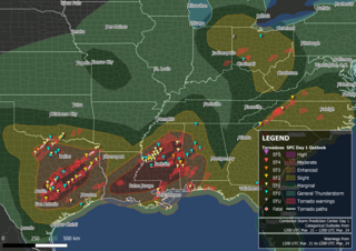
Between March 29–31, 2022, a line of strong to severe thunderstorms and multiple supercells swept through portions of the United States and brought widespread wind damage and several strong tornadoes across a large part of the Midwestern, Southern, and Eastern United States. An EF3 tornado was confirmed in Springdale, Arkansas, while an EF1 tornado passed close to downtown Jackson, Mississippi. Numerous tornadoes, some of which were strong occurred over Mississippi, Alabama the evening of March 30 and into the early morning of March 31. Multiple tornadoes also occurred in the Florida Panhandle, including an intense EF3 tornado that killed two people and injured three others near Alford, Florida, and in other states such as North Carolina and Pennsylvania. Producing a total of 90 tornadoes, this was the largest tornado outbreak of 2022.
A four-day tornado outbreak affected the Central and Southern United States in mid-December 2022. The outbreak produced strong tornadoes in Oklahoma, Texas, Louisiana, Mississippi, and Georgia, resulting in severe damage and three fatalities. On December 13, a high-end EF1 tornado was caught on video from multiple angles as it caused considerable damage in Grapevine, Texas, where five people were injured, and multiple EF2 tornadoes caused significant damage in other parts of Texas and Oklahoma that morning. Two large EF2 tornadoes occurred near DeBerry, Texas and Keachi, Louisiana to the southwest of Shreveport, Louisiana, with the second one causing severe damage and two fatalities. An EF3 tornado struck the northern fringes of Farmerville, causing major structural damage and 14 injuries.
↑ National Weather Service in Paducah, Kentucky (2022). Kentucky Event Report: EF2 Tornado (Report). National Centers for Environmental Information. Retrieved April 18, 2022.
↑ National Weather Service in Louisville, Kentucky (2022). Kentucky Event Report: EF0 Tornado (Report). National Centers for Environmental Information. Retrieved April 18, 2022.
↑ National Weather Service in Paducah, Kentucky (2022). Kentucky Event Report: EF0 Tornado (Report). National Centers for Environmental Information. Retrieved April 18, 2022.
↑ National Weather Service in Louisville, Kentucky (2022). Kentucky Event Report: EF0 Tornado (Report). National Centers for Environmental Information. Retrieved April 18, 2022.
↑ National Weather Service in Louisville, Kentucky (2022). Kentucky Event Report: EF1 Tornado (Report). National Centers for Environmental Information. Retrieved April 18, 2022.
↑ National Weather Service in Louisville, Kentucky (2022). Kentucky Event Report: EF1 Tornado (Report). National Centers for Environmental Information. Retrieved April 18, 2022.
↑ National Weather Service in Louisville, Kentucky (2022). Kentucky Event Report: EF1 Tornado (Report). National Centers for Environmental Information. Retrieved April 18, 2022.
↑ National Weather Service in Jackson, Kentucky (2022). Kentucky Event Report: EF1 Tornado (Report). National Centers for Environmental Information. Retrieved April 18, 2022.
↑ National Weather Service in Huntsville, Alabama (2022). Alabama Event Report: EF1 Tornado (Report). National Centers for Environmental Information. Retrieved December 30, 2022.
↑ National Weather Service in Nashville, Tennessee (2022). Tennessee Event Report: EF1 Tornado (Report). National Centers for Environmental Information. Retrieved April 18, 2022.
↑ National Weather Service in Huntsville, Alabama (2022). Alabama Event Report: EF0 Tornado (Report). National Centers for Environmental Information. Retrieved December 30, 2022.
↑ National Weather Service in Huntsville, Alabama (2022). Alabama Event Report: EF0 Tornado (Report). National Centers for Environmental Information. Retrieved December 30, 2022.
↑ National Weather Service in Huntsville, Alabama (2022). Alabama Event Report: EF0 Tornado (Report). National Centers for Environmental Information. Retrieved December 30, 2022.
↑ National Weather Service in Huntsville, Alabama (2022). Alabama Event Report: EF0 Tornado (Report). National Centers for Environmental Information. Retrieved December 30, 2022.
↑ National Weather Service in Tallahassee, Florida (2022). Florida Event Report: EF0 Tornado (Report). National Centers for Environmental Information. Retrieved April 18, 2022.
↑ National Weather Service in Atlanta, Georgia (2022). Georgia Event Report: EF0 Tornado (Report). National Centers for Environmental Information. Retrieved December 30, 2022.
↑ National Weather Service in Atlanta, Georgia (2022). Georgia Event Report: EF0 Tornado (Report). National Centers for Environmental Information. Retrieved December 30, 2022.
↑ National Weather Service in Raleigh, North Carolina (2022). North Carolina Event Report: EF0 Tornado (Report). National Centers for Environmental Information. Retrieved April 18, 2022.
↑ National Weather Service in Raleigh, North Carolina (2022). North Carolina Event Report: EF1 Tornado (Report). National Centers for Environmental Information. Retrieved April 18, 2022.
↑ National Weather Service in Houston, Texas (2022). Texas Event Report: EF0 Tornado (Report). National Centers for Environmental Information. Retrieved April 18, 2022.
↑ National Weather Service in Houston, Texas (2022). Texas Event Report: EF0 Tornado (Report). National Centers for Environmental Information. Retrieved April 18, 2022.
↑ National Weather Service in Houston, Texas (2022). Texas Event Report: EF0 Tornado (Report). National Centers for Environmental Information. Retrieved April 18, 2022.
↑ National Weather Service in Houston, Texas (2022). Texas Event Report: EF0 Tornado (Report). National Centers for Environmental Information. Retrieved April 18, 2022.
↑ National Weather Service in Houston, Texas (2022). Texas Event Report: EF1 Tornado (Report). National Centers for Environmental Information. Retrieved April 18, 2022.
↑ National Weather Service in Houston, Texas (2022). Texas Event Report: EF1 Tornado (Report). National Centers for Environmental Information. Retrieved April 18, 2022.
↑ National Weather Service in Shreveport, Louisiana (2022). Louisiana Event Report: EF1 Tornado (Report). National Centers for Environmental Information. Retrieved April 18, 2022.
↑ National Weather Service in Shreveport, Louisiana (2022). Louisiana Event Report: EF2 Tornado (Report). National Centers for Environmental Information. Retrieved April 18, 2022.
↑ National Weather Service in Birmingham, Alabama (2022). Alabama Event Report: EF0 Tornado (Report). National Centers for Environmental Information. Retrieved April 18, 2022.
↑ National Weather Service in Mobile, Alabama (2022). Alabama Event Report: EF0 Tornado (Report). National Centers for Environmental Information. Retrieved April 18, 2022.
↑ National Weather Service in Mobile, Alabama (2022). Alabama Event Report: EF0 Tornado (Report). National Centers for Environmental Information. Retrieved April 18, 2022.
↑ National Weather Service in Mobile, Alabama (2024). Local Tornado Reanalysis Project (Report). weather.gov. Retrieved January 25, 2024.
↑ National Weather Service in Tallahassee, Florida (2022). Florida Event Report: EF1 Tornado (Report). National Centers for Environmental Information. Retrieved April 18, 2022.
↑ National Weather Service in Tampa, Florida (2022). Florida Event Report: EF1 Tornado (Report). National Centers for Environmental Information. Retrieved April 18, 2022.
↑ National Weather Service in Tampa, Florida (2022). Florida Event Report: EF1 Tornado (Report). National Centers for Environmental Information. Retrieved April 18, 2022.
↑ National Weather Service in Tampa, Florida (2022). Florida Event Report: EF2 Tornado (Report). National Centers for Environmental Information. Retrieved April 18, 2022.
↑ National Weather Service in Tampa, Florida (2022). Florida Event Report: EF0 Tornado (Report). National Centers for Environmental Information. Retrieved April 18, 2022.
↑ National Weather Service in Melbourne, Florida (2022). Florida Event Report: EF0 Tornado (Report). National Centers for Environmental Information. Retrieved April 18, 2022.
↑ National Weather Service in Melbourne, Florida (2022). Florida Event Report: EF0 Tornado (Report). National Centers for Environmental Information. Retrieved April 18, 2022.
↑ "Preliminary Local Storm Report". Iowa Environmental Mesonet. National Weather Service in Melbourne, Florida. March 11, 2022. Retrieved March 11, 2022.
↑ National Weather Service in Fort Worth, Texas (2022). Texas Event Report: EF1 Tornado (Report). National Centers for Environmental Information. Retrieved December 1, 2022.
↑ National Weather Service in Fort Worth, Texas (2022). Texas Event Report: EF3 Tornado (Report). National Centers for Environmental Information. Retrieved December 1, 2022.National Weather Service in Fort Worth, Texas (2022). Texas Event Report: EF0 Tornado (Report). National Centers for Environmental Information. Retrieved December 1, 2022.
↑ National Weather Service in Fort Worth, Texas (2022). Texas Event Report: EF1 Tornado (Report). National Centers for Environmental Information. Retrieved December 1, 2022.
↑ National Weather Service in Fort Worth, Texas (2022). Texas Event Report: EF1 Tornado (Report). National Centers for Environmental Information. Retrieved December 1, 2022.
↑ National Weather Service in Fort Worth, Texas (2022). Texas Event Report: EF0 Tornado (Report). National Centers for Environmental Information. Retrieved December 1, 2022.
↑ National Weather Service in Fort Worth, Texas (2022). Texas Event Report: EF1 Tornado (Report). National Centers for Environmental Information. Retrieved December 1, 2022.
↑ National Weather Service in Norman, Oklahoma (2022). Oklahoma Event Report: EF0 Tornado (Report). National Centers for Environmental Information. Retrieved December 1, 2022.
↑ National Weather Service in Fort Worth, Texas (2022). Texas Event Report: EF1 Tornado (Report). National Centers for Environmental Information. Retrieved December 1, 2022.
↑ National Weather Service in Fort Worth, Texas (2022). Texas Event Report: EF0 Tornado (Report). National Centers for Environmental Information. Retrieved December 1, 2022.
↑ National Weather Service in Fort Worth, Texas (2022). Texas Event Report: EF1 Tornado (Report). National Centers for Environmental Information. Retrieved December 1, 2022.
↑ National Weather Service in Austin, Texas (2022). Texas Event Report: EF2 Tornado (Report). National Centers for Environmental Information. Retrieved December 1, 2022.National Weather Service in Austin, Texas (2022). Texas Event Report: EF2 Tornado (Report). National Centers for Environmental Information. Retrieved December 1, 2022.
↑ National Weather Service in Austin, Texas (2022). Texas Event Report: EF1 Tornado (Report). National Centers for Environmental Information. Retrieved December 1, 2022.National Weather Service in Austin, Texas (2022). Texas Event Report: EF0 Tornado (Report). National Centers for Environmental Information. Retrieved December 1, 2022.
↑ National Weather Service in Austin, Texas (2022). Texas Event Report: EF1 Tornado (Report). National Centers for Environmental Information. Retrieved December 1, 2022.National Weather Service in Austin, Texas (2022). Texas Event Report: EF2 Tornado (Report). National Centers for Environmental Information. Retrieved December 1, 2022.National Weather Service in Fort Worth, Texas (2022). Texas Event Report: EF1 Tornado (Report). National Centers for Environmental Information. Retrieved December 1, 2022.
↑ National Weather Service in Fort Worth, Texas (2022). Texas Event Report: EF2 Tornado (Report). National Centers for Environmental Information. Retrieved December 3, 2022.National Weather Service in Norman, Oklahoma (2022). Oklahoma Event Report: EF2 Tornado (Report). National Centers for Environmental Information. Retrieved December 3, 2022.
↑ National Weather Service in Fort Worth, Texas (2022). Texas Event Report: EF0 Tornado (Report). National Centers for Environmental Information. Retrieved December 3, 2022.
↑ National Weather Service in Norman, Oklahoma (2022). Oklahoma Event Report: EF1 Tornado (Report). National Centers for Environmental Information. Retrieved December 3, 2022.
↑ National Weather Service in Austin, Texas (2022). Texas Event Report: EF0 Tornado (Report). National Centers for Environmental Information. Retrieved December 3, 2022.National Weather Service in Austin, Texas (2022). Texas Event Report: EF2 Tornado (Report). National Centers for Environmental Information. Retrieved December 3, 2022.
↑ National Weather Service in Fort Worth, Texas (2022). Texas Event Report: EF0 Tornado (Report). National Centers for Environmental Information. Retrieved December 3, 2022.
↑ National Weather Service in Norman, Oklahoma (2022). Oklahoma Event Report: EF0 Tornado (Report). National Centers for Environmental Information. Retrieved December 3, 2022.
↑ National Weather Service in Norman, Oklahoma (2022). Oklahoma Event Report: EF1 Tornado (Report). National Centers for Environmental Information. Retrieved December 3, 2022.
↑ National Weather Service in Austin, Texas (2022). Texas Event Report: EF0 Tornado (Report). National Centers for Environmental Information. Retrieved December 3, 2022.National Weather Service in Austin, Texas (2022). Texas Event Report: EF0 Tornado (Report). National Centers for Environmental Information. Retrieved December 3, 2022.
↑ National Weather Service in Fort Worth, Texas (2022). Texas Event Report: EF0 Tornado (Report). National Centers for Environmental Information. Retrieved December 3, 2022.
↑ National Weather Service in Austin, Texas (2022). Texas Event Report: EF1 Tornado (Report). National Centers for Environmental Information. Retrieved December 3, 2022.
↑ National Weather Service in Fort Worth, Texas (2022). Texas Event Report: EF0 Tornado (Report). National Centers for Environmental Information. Retrieved December 3, 2022.
↑ National Weather Service in Houston, Texas (2022). Texas Event Report: EF0 Tornado (Report). National Centers for Environmental Information. Retrieved December 3, 2022.
↑ National Weather Service in Houston, Texas (2022). Texas Event Report: EF0 Tornado (Report). National Centers for Environmental Information. Retrieved December 3, 2022.
↑ National Weather Service in Houston, Texas (2022). Texas Event Report: EF1 Tornado (Report). National Centers for Environmental Information. Retrieved December 3, 2022.
↑ National Weather Service in Houston, Texas (2022). Texas Event Report: EF1 Tornado (Report). National Centers for Environmental Information. Retrieved December 3, 2022.
↑ National Weather Service in Shreveport, Louisiana (2022). Texas Event Report: EF2 Tornado (Report). National Centers for Environmental Information. Retrieved December 3, 2022.National Weather Service in Shreveport, Louisiana (2022). Texas Event Report: EF2 Tornado (Report). National Centers for Environmental Information. Retrieved December 3, 2022.National Weather Service in Shreveport, Louisiana (2022). Texas Event Report: EF2 Tornado (Report). National Centers for Environmental Information. Retrieved December 3, 2022.National Weather Service in Shreveport, Louisiana (2022). Texas Event Report: EF2 Tornado (Report). National Centers for Environmental Information. Retrieved December 3, 2022.
↑ National Weather Service in Shreveport, Louisiana (2022). Texas Event Report: EF2 Tornado (Report). National Centers for Environmental Information. Retrieved December 3, 2022.National Weather Service in Shreveport, Louisiana (2022). Texas Event Report: EF2 Tornado (Report). National Centers for Environmental Information. Retrieved December 3, 2022.National Weather Service in Shreveport, Louisiana (2022). Texas Event Report: EF2 Tornado (Report). National Centers for Environmental Information. Retrieved December 3, 2022.
↑ National Weather Service in Shreveport, Louisiana (2022). Texas Event Report: EF1 Tornado (Report). National Centers for Environmental Information. Retrieved December 3, 2022.
↑ National Weather Service in Shreveport, Louisiana (2022). Texas Event Report: EF1 Tornado (Report). National Centers for Environmental Information. Retrieved December 3, 2022.
↑ National Weather Service in Shreveport, Louisiana (2022). Texas Event Report: EF2 Tornado (Report). National Centers for Environmental Information. Retrieved December 5, 2022.
↑ National Weather Service in Shreveport, Louisiana (2022). Texas Event Report: EF2 Tornado (Report). National Centers for Environmental Information. Retrieved December 5, 2022.
↑ National Weather Service in Shreveport, Louisiana (2022). Texas Event Report: EF1 Tornado (Report). National Centers for Environmental Information. Retrieved December 5, 2022.
↑ National Weather Service in Houston, Texas (2022). Texas Event Report: EF0 Tornado (Report). National Centers for Environmental Information. Retrieved December 5, 2022.
↑ National Weather Service in Houston, Texas (2022). Texas Event Report: EF0 Tornado (Report). National Centers for Environmental Information. Retrieved December 5, 2022.
↑ National Weather Service in Jackson, Mississippi (2022). Louisiana Event Report: EF1 Tornado (Report). National Centers for Environmental Information. Retrieved December 5, 2022.
↑ National Weather Service in Jackson, Mississippi (2022). Mississippi Event Report: EFU Tornado (Report). National Centers for Environmental Information. Retrieved December 5, 2022.
↑ National Weather Service in Jackson, Mississippi (2022). Mississippi Event Report: EF0 Tornado (Report). National Centers for Environmental Information. Retrieved December 5, 2022.
↑ National Weather Service in Jackson, Mississippi (2022). Mississippi Event Report: EF0 Tornado (Report). National Centers for Environmental Information. Retrieved December 5, 2022.
↑ National Weather Service in Jackson, Mississippi (2022). Mississippi Event Report: EF1 Tornado (Report). National Centers for Environmental Information. Retrieved December 5, 2022.National Weather Service in Jackson, Mississippi (2022). Mississippi Event Report: EF1 Tornado (Report). National Centers for Environmental Information. Retrieved December 5, 2022.
↑ National Weather Service in Jackson, Mississippi (2022). Mississippi Event Report: EFU Tornado (Report). National Centers for Environmental Information. Retrieved December 5, 2022.
↑ National Weather Service in Jackson, Mississippi (2022). Mississippi Event Report: EF2 Tornado (Report). National Centers for Environmental Information. Retrieved December 5, 2022.
↑ National Weather Service in Jackson, Mississippi (2022). Mississippi Event Report: EF2 Tornado (Report). National Centers for Environmental Information. Retrieved December 5, 2022.
↑ National Weather Service in Jackson, Mississippi (2022). Mississippi Event Report: EF1 Tornado (Report). National Centers for Environmental Information. Retrieved December 5, 2022.
↑ National Weather Service in Jackson, Mississippi (2022). Mississippi Event Report: EF1 Tornado (Report). National Centers for Environmental Information. Retrieved December 5, 2022.
↑ National Weather Service in Jackson, Mississippi (2022). Mississippi Event Report: EF1 Tornado (Report). National Centers for Environmental Information. Retrieved December 5, 2022.
↑ National Weather Service in Jackson, Mississippi (2022). Mississippi Event Report: EF1 Tornado (Report). National Centers for Environmental Information. Retrieved December 5, 2022.
↑ National Weather Service in Jackson, Mississippi (2022). Mississippi Event Report: EF1 Tornado (Report). National Centers for Environmental Information. Retrieved December 5, 2022.
↑ National Weather Service in Jackson, Mississippi (2022). Mississippi Event Report: EF1 Tornado (Report). National Centers for Environmental Information. Retrieved December 5, 2022.
↑ National Weather Service in Jackson, Mississippi (2022). Mississippi Event Report: EFU Tornado (Report). National Centers for Environmental Information. Retrieved December 5, 2022.
↑ National Weather Service in Jackson, Mississippi (2022). Mississippi Event Report: EFU Tornado (Report). National Centers for Environmental Information. Retrieved December 5, 2022.
↑ National Weather Service in Jackson, Mississippi (2022). Mississippi Event Report: EF0 Tornado (Report). National Centers for Environmental Information. Retrieved December 5, 2022.
↑ National Weather Service in Jackson, Mississippi (2022). Mississippi Event Report: EF1 Tornado (Report). National Centers for Environmental Information. Retrieved December 5, 2022.
↑ National Weather Service in Jackson, Mississippi (2022). Mississippi Event Report: EF1 Tornado (Report). National Centers for Environmental Information. Retrieved December 5, 2022.
↑ National Weather Service in Jackson, Mississippi (2022). Mississippi Event Report: EF1 Tornado (Report). National Centers for Environmental Information. Retrieved December 5, 2022.
↑ National Weather Service in Jackson, Mississippi (2022). Mississippi Event Report: EF1 Tornado (Report). National Centers for Environmental Information. Retrieved December 5, 2022.
↑ National Weather Service in Jackson, Mississippi (2022). Mississippi Event Report: EF0 Tornado (Report). National Centers for Environmental Information. Retrieved December 9, 2022.
↑ National Weather Service in Jackson, Mississippi (2022). Mississippi Event Report: EF1 Tornado (Report). National Centers for Environmental Information. Retrieved December 9, 2022.
↑ National Weather Service in Jackson, Mississippi (2022). Mississippi Event Report: EF1 Tornado (Report). National Centers for Environmental Information. Retrieved December 9, 2022.
↑ National Weather Service in Jackson, Mississippi (2022). Mississippi Event Report: EF1 Tornado (Report). National Centers for Environmental Information. Retrieved December 9, 2022.
↑ National Weather Service in Jackson, Mississippi (2022). Mississippi Event Report: EF1 Tornado (Report). National Centers for Environmental Information. Retrieved December 9, 2022.
↑ National Weather Service in Jackson, Mississippi (2022). Mississippi Event Report: EF1 Tornado (Report). National Centers for Environmental Information. Retrieved December 9, 2022.
↑ National Weather Service in Jackson, Mississippi (2022). Mississippi Event Report: EF0 Tornado (Report). National Centers for Environmental Information. Retrieved December 9, 2022.
↑ National Weather Service in Jackson, Mississippi (2022). Mississippi Event Report: EF0 Tornado (Report). National Centers for Environmental Information. Retrieved December 9, 2022.
↑ National Weather Service in Jackson, Mississippi (2022). Mississippi Event Report: EF0 Tornado (Report). National Centers for Environmental Information. Retrieved December 9, 2022.
↑ National Weather Service in Jackson, Mississippi (2022). Mississippi Event Report: EF3 Tornado (Report). National Centers for Environmental Information. Retrieved December 9, 2022.
↑ National Weather Service in Jackson, Mississippi (2022). Mississippi Event Report: EF1 Tornado (Report). National Centers for Environmental Information. Retrieved December 9, 2022.
↑ National Weather Service in Memphis, Tennessee (2022). Mississippi Event Report: EF1 Tornado (Report). National Centers for Environmental Information. Retrieved December 9, 2022.
↑ National Weather Service in Jackson, Mississippi (2022). Mississippi Event Report: EF1 Tornado (Report). National Centers for Environmental Information. Retrieved December 9, 2022.
↑ National Weather Service in Jackson, Mississippi (2022). Mississippi Event Report: EF0 Tornado (Report). National Centers for Environmental Information. Retrieved December 9, 2022.
↑ National Weather Service in Mobile, Alabama (2022). Alabama Event Report: EF2 Tornado (Report). National Centers for Environmental Information. Retrieved December 9, 2022.
↑ National Weather Service in Mobile, Alabama (2024). Local Tornado Reanalysis Project (Report). weather.gov. Retrieved January 25, 2024.
↑ National Weather Service in Huntsville, Alabama (2022). Alabama Event Report: EF0 Tornado (Report). National Centers for Environmental Information. Retrieved December 9, 2022.
↑ National Weather Service in Jackson, Mississippi (2022). Mississippi Event Report: EF1 Tornado (Report). National Centers for Environmental Information. Retrieved December 9, 2022.
↑ National Weather Service in Birmingham, Alabama (2022). Alabama Event Report: EF0 Tornado (Report). National Centers for Environmental Information. Retrieved December 9, 2022.
↑ National Weather Service in Birmingham, Alabama (2022). Alabama Event Report: EF0 Tornado (Report). National Centers for Environmental Information. Retrieved December 9, 2022.
↑ National Weather Service in Birmingham, Alabama (2022). Alabama Event Report: EF0 Tornado (Report). National Centers for Environmental Information. Retrieved December 9, 2022.
↑ National Weather Service in Mobile, Alabama (2022). Alabama Event Report: EF1 Tornado (Report). National Centers for Environmental Information. Retrieved December 9, 2022.
↑ National Weather Service in Mobile, Alabama (2024). Local Tornado Reanalysis Project (Report). weather.gov. Retrieved January 25, 2024.
↑ National Weather Service in Birmingham, Alabama (2022). Alabama Event Report: EF0 Tornado (Report). National Centers for Environmental Information. Retrieved December 9, 2022.
↑ National Weather Service in Birmingham, Alabama (2022). Alabama Event Report: EF0 Tornado (Report). National Centers for Environmental Information. Retrieved December 9, 2022.
↑ National Weather Service in New Orleans, Louisiana (2022). Louisiana Event Report: EF0 Tornado (Report). National Centers for Environmental Information. Retrieved December 9, 2022.
↑ National Weather Service in New Orleans, Louisiana (2022). Louisiana Event Report: EF0 Tornado (Report). National Centers for Environmental Information. Retrieved December 9, 2022.
↑ National Weather Service in New Orleans, Louisiana (2022). Louisiana Event Report: EF3 Tornado (Report). National Centers for Environmental Information. Retrieved December 9, 2022.
↑ National Weather Service in New Orleans, Louisiana (2022). Louisiana Event Report: EF1 Tornado (Report). National Centers for Environmental Information. Retrieved December 9, 2022.
↑ National Weather Service in Birmingham, Alabama (2022). Alabama Event Report: EF0 Tornado (Report). National Centers for Environmental Information. Retrieved December 9, 2022.National Weather Service in Birmingham, Alabama (2022). Alabama Event Report: EF0 Tornado (Report). National Centers for Environmental Information. Retrieved December 9, 2022.
↑ National Weather Service in Mobile, Alabama (2022). Alabama Event Report: EF1 Tornado (Report). National Centers for Environmental Information. Retrieved December 9, 2022.
↑ National Weather Service in Jacksonville, Florida (2022). Georgia Event Report: EF0 Tornado (Report). National Centers for Environmental Information. Retrieved December 10, 2022.
↑ National Weather Service in Wilmington, Ohio (2022). Ohio Event Report: EF0 Tornado (Report). National Centers for Environmental Information. Retrieved December 10, 2022.
↑ National Weather Service in Wilmington, Ohio (2022). Ohio Event Report: EF0 Tornado (Report). National Centers for Environmental Information. Retrieved December 10, 2022.
↑ National Weather Service in Northern Indiana (2022). Ohio Event Report: EF0 Tornado (Report). National Centers for Environmental Information. Retrieved December 10, 2022.
↑ National Weather Service in Cleveland, Ohio (2022). Ohio Event Report: EF0 Tornado (Report). National Centers for Environmental Information. Retrieved December 10, 2022.
↑ National Weather Service in Greenville-Spartanburg, South Carolina (2022). South Carolina Event Report: EF2 Tornado (Report). National Centers for Environmental Information. Retrieved December 10, 2022.
↑ National Weather Service in Greenville-Spartanburg, South Carolina (2022). South Carolina Event Report: EF0 Tornado (Report). National Centers for Environmental Information. Retrieved December 10, 2022.
↑ National Weather Service in Blacksburg, Virginia (2022). Virginia Event Report: EF2 Tornado (Report). National Centers for Environmental Information. Retrieved December 10, 2022.
↑ National Weather Service in Greenville-Spartanburg, South Carolina (2022). North Carolina Event Report: EF1 Tornado (Report). National Centers for Environmental Information. Retrieved December 10, 2022.
↑ National Weather Service in Topeka, Kansas (2022). Kansas Event Report: EF1 Tornado (Report). National Centers for Environmental Information. Retrieved December 10, 2022.
↑ National Weather Service in Kansas City, Missouri (2022). Missouri Event Report: EF1 Tornado (Report). National Centers for Environmental Information. Retrieved December 10, 2022.
↑ National Weather Service in Tulsa, Oklahoma (2022). Arkansas Event Report: EF3 Tornado (Report). National Centers for Environmental Information. Retrieved December 10, 2022.
↑ National Weather Service in Fort Worth, Texas (2022). Texas Event Report: EF1 Tornado (Report). National Centers for Environmental Information. Retrieved December 10, 2022.
↑ National Weather Service in Tulsa, Oklahoma (2022). Oklahoma Event Report: EF0 Tornado (Report). National Centers for Environmental Information. Retrieved December 11, 2022.
↑ National Weather Service in Shreveport, Louisiana (2022). Texas Event Report: EF1 Tornado (Report). National Centers for Environmental Information. Retrieved December 11, 2022.
↑ National Weather Service in Little Rock, Arkansas (2022). Arkansas Event Report: EF1 Tornado (Report). National Centers for Environmental Information. Retrieved December 11, 2022.
↑ National Weather Service in Shreveport, Louisiana (2022). Texas Event Report: EF1 Tornado (Report). National Centers for Environmental Information. Retrieved December 11, 2022.
↑ National Weather Service in Lake Charles, Louisiana (2022). Texas Event Report: EF1 Tornado (Report). National Centers for Environmental Information. Retrieved December 11, 2022.
↑ National Weather Service in Shreveport, Louisiana (2022). Louisiana Event Report: EF0 Tornado (Report). National Centers for Environmental Information. Retrieved December 11, 2022.
↑ National Weather Service in Shreveport, Louisiana (2022). Louisiana Event Report: EF0 Tornado (Report). National Centers for Environmental Information. Retrieved December 11, 2022.
↑ National Weather Service in Shreveport, Louisiana (2022). Louisiana Event Report: EF1 Tornado (Report). National Centers for Environmental Information. Retrieved December 11, 2022.
↑ National Weather Service in Shreveport, Louisiana (2022). Louisiana Event Report: EF1 Tornado (Report). National Centers for Environmental Information. Retrieved December 11, 2022.
↑ National Weather Service in Shreveport, Louisiana (2022). Louisiana Event Report: EF0 Tornado (Report). National Centers for Environmental Information. Retrieved December 11, 2022.
↑ National Weather Service in Shreveport, Louisiana (2022). Louisiana Event Report: EF1 Tornado (Report). National Centers for Environmental Information. Retrieved December 11, 2022.
↑ National Weather Service in Lake Charles, Louisiana (2022). Louisiana Event Report: EF1 Tornado (Report). National Centers for Environmental Information. Retrieved December 11, 2022.
↑ National Weather Service in Lake Charles, Louisiana (2022). Louisiana Event Report: EF1 Tornado (Report). National Centers for Environmental Information. Retrieved December 11, 2022.
↑ National Weather Service in Lake Charles, Louisiana (2022). Louisiana Event Report: EF1 Tornado (Report). National Centers for Environmental Information. Retrieved December 11, 2022.
↑ National Weather Service in Jackson, Mississippi (2022). Louisiana Event Report: EF1 Tornado (Report). National Centers for Environmental Information. Retrieved December 11, 2022.
↑ National Weather Service in Jackson, Mississippi (2022). Louisiana Event Report: EF0 Tornado (Report). National Centers for Environmental Information. Retrieved December 11, 2022.
↑ National Weather Service in Jackson, Mississippi (2022). Louisiana Event Report: EF1 Tornado (Report). National Centers for Environmental Information. Retrieved December 11, 2022.
↑ National Weather Service in Jackson, Mississippi (2022). Louisiana Event Report: EF2 Tornado (Report). National Centers for Environmental Information. Retrieved December 11, 2022.
↑ National Weather Service in Jackson, Mississippi (2022). Mississippi Event Report: EF1 Tornado (Report). National Centers for Environmental Information. Retrieved December 11, 2022.
↑ National Weather Service in Jackson, Mississippi (2022). Louisiana Event Report: EF1 Tornado (Report). National Centers for Environmental Information. Retrieved December 11, 2022.
↑ National Weather Service in Jackson, Mississippi (2022). Mississippi Event Report: EF1 Tornado (Report). National Centers for Environmental Information. Retrieved December 11, 2022.
↑ National Weather Service in Jackson, Mississippi (2022). Mississippi Event Report: EF1 Tornado (Report). National Centers for Environmental Information. Retrieved December 11, 2022.
↑ National Weather Service in Jackson, Mississippi (2022). Mississippi Event Report: EF1 Tornado (Report). National Centers for Environmental Information. Retrieved December 11, 2022.
↑ National Weather Service in Jackson, Mississippi (2022). Mississippi Event Report: EF1 Tornado (Report). National Centers for Environmental Information. Retrieved December 11, 2022.
↑ National Weather Service in Jackson, Mississippi (2022). Mississippi Event Report: EF1 Tornado (Report). National Centers for Environmental Information. Retrieved December 11, 2022.
↑ National Weather Service in Jackson, Mississippi (2022). Mississippi Event Report: EF1 Tornado (Report). National Centers for Environmental Information. Retrieved December 11, 2022.
↑ National Weather Service in Jackson, Mississippi (2022). Mississippi Event Report: EF1 Tornado (Report). National Centers for Environmental Information. Retrieved December 11, 2022.
↑ National Weather Service in Jackson, Mississippi (2022). Mississippi Event Report: EF1 Tornado (Report). National Centers for Environmental Information. Retrieved December 11, 2022.
↑ National Weather Service in Jackson, Mississippi (2022). Mississippi Event Report: EF1 Tornado (Report). National Centers for Environmental Information. Retrieved December 11, 2022.
↑ National Weather Service in Memphis, Tennessee (2022). Mississippi Event Report: EF1 Tornado (Report). National Centers for Environmental Information. Retrieved December 11, 2022.
↑ National Weather Service in Jackson, Mississippi (2022). Mississippi Event Report: EF1 Tornado (Report). National Centers for Environmental Information. Retrieved December 11, 2022.
↑ National Weather Service in Jackson, Mississippi (2022). Mississippi Event Report: EF1 Tornado (Report). National Centers for Environmental Information. Retrieved December 11, 2022.
↑ National Weather Service in Jackson, Mississippi (2022). Mississippi Event Report: EF1 Tornado (Report). National Centers for Environmental Information. Retrieved December 11, 2022.
↑ National Weather Service in Jackson, Mississippi (2022). Mississippi Event Report: EF1 Tornado (Report). National Centers for Environmental Information. Retrieved December 11, 2022.
↑ National Weather Service in Jackson, Mississippi (2022). Mississippi Event Report: EF1 Tornado (Report). National Centers for Environmental Information. Retrieved December 11, 2022.
↑ National Weather Service in Paducah, Kentucky (2022). Illinois Event Report: EF0 Tornado (Report). National Centers for Environmental Information. Retrieved December 11, 2022.
↑ National Weather Service in Memphis, Tennessee (2022). Mississippi Event Report: EF1 Tornado (Report). National Centers for Environmental Information. Retrieved December 11, 2022.
↑ National Weather Service in Jackson, Mississippi (2022). Mississippi Event Report: EF2 Tornado (Report). National Centers for Environmental Information. Retrieved December 11, 2022.
↑ National Weather Service in Jackson, Mississippi (2022). Mississippi Event Report: EF1 Tornado (Report). National Centers for Environmental Information. Retrieved December 11, 2022.
↑ National Weather Service in Paducah, Kentucky (2022). Illinois Event Report: EF0 Tornado (Report). National Centers for Environmental Information. Retrieved December 11, 2022.
↑ National Weather Service in Paducah, Kentucky (2022). Illinois Event Report: EF1 Tornado (Report). National Centers for Environmental Information. Retrieved December 11, 2022.
↑ National Weather Service in New Orleans, Louisiana (2022). Louisiana Event Report: EF1 Tornado (Report). National Centers for Environmental Information. Retrieved December 11, 2022.
↑ National Weather Service in Memphis, Tennessee (2022). Tennessee Event Report: EF1 Tornado (Report). National Centers for Environmental Information. Retrieved December 11, 2022.
↑ National Weather Service in Memphis, Tennessee (2022). Tennessee Event Report: EF1 Tornado (Report). National Centers for Environmental Information. Retrieved December 11, 2022.
↑ National Weather Service in Memphis, Tennessee (2022). Tennessee Event Report: EF1 Tornado (Report). National Centers for Environmental Information. Retrieved December 11, 2022.
↑ National Weather Service in Memphis, Tennessee (2022). Tennessee Event Report: EF1 Tornado (Report). National Centers for Environmental Information. Retrieved December 11, 2022.
↑ National Weather Service in Paducah, Kentucky (2022). Indiana Event Report: EF1 Tornado (Report). National Centers for Environmental Information. Retrieved December 13, 2022.
↑ National Weather Service in Memphis, Tennessee (2022). Mississippi Event Report: EF0 Tornado (Report). National Centers for Environmental Information. Retrieved December 13, 2022.
↑ National Weather Service in Jackson, Mississippi (2022). Mississippi Event Report: EF0 Tornado (Report). National Centers for Environmental Information. Retrieved December 13, 2022.
↑ National Weather Service in Jackson, Mississippi (2022). Mississippi Event Report: EF0 Tornado (Report). National Centers for Environmental Information. Retrieved December 13, 2022.
↑ National Weather Service in Jackson, Mississippi (2022). Mississippi Event Report: EF0 Tornado (Report). National Centers for Environmental Information. Retrieved December 13, 2022.
↑ National Weather Service in New Orleans, Louisiana (2022). Louisiana Event Report: EF0 Tornado (Report). National Centers for Environmental Information. Retrieved December 13, 2022.
↑ National Weather Service in Jackson, Mississippi (2022). Mississippi Event Report: EF0 Tornado (Report). National Centers for Environmental Information. Retrieved December 13, 2022.
↑ National Weather Service in Jackson, Mississippi (2022). Mississippi Event Report: EF0 Tornado (Report). National Centers for Environmental Information. Retrieved December 13, 2022.
↑ National Weather Service in Jackson, Mississippi (2022). Mississippi Event Report: EF1 Tornado (Report). National Centers for Environmental Information. Retrieved December 13, 2022.
↑ National Weather Service in Jackson, Mississippi (2022). Mississippi Event Report: EF2 Tornado (Report). National Centers for Environmental Information. Retrieved December 13, 2022.
↑ National Weather Service in Jackson, Mississippi (2022). Mississippi Event Report: EF2 Tornado (Report). National Centers for Environmental Information. Retrieved December 13, 2022.
↑ National Weather Service in Jackson, Mississippi (2022). Mississippi Event Report: EF0 Tornado (Report). National Centers for Environmental Information. Retrieved December 13, 2022.
↑ National Weather Service in Jackson, Mississippi (2022). Mississippi Event Report: EF1 Tornado (Report). National Centers for Environmental Information. Retrieved December 13, 2022.
↑ National Weather Service in Jackson, Mississippi (2022). Mississippi Event Report: EF1 Tornado (Report). National Centers for Environmental Information. Retrieved December 13, 2022.
↑ National Weather Service in Mobile, Alabama (2022). Mississippi Event Report: EF1 Tornado (Report). National Centers for Environmental Information. Retrieved December 13, 2022.
↑ National Weather Service in Mobile, Alabama (2022). Mississippi Event Report: EF1 Tornado (Report). National Centers for Environmental Information. Retrieved December 13, 2022.
↑ National Weather Service in Mobile, Alabama (2022). Mississippi Event Report: EF2 Tornado (Report). National Centers for Environmental Information. Retrieved December 13, 2022.
↑ National Weather Service in Mobile, Alabama (2022). Mississippi Event Report: EF2 Tornado (Report). National Centers for Environmental Information. Retrieved December 13, 2022.
↑ National Weather Service in Mobile, Alabama (2022). Mississippi Event Report: EF1 Tornado (Report). National Centers for Environmental Information. Retrieved December 13, 2022.
↑ National Weather Service in Birmingham, Alabama (2022). Alabama Event Report: EF1 Tornado (Report). National Centers for Environmental Information. Retrieved December 13, 2022.
↑ National Weather Service in Birmingham, Alabama (2022). Alabama Event Report: EF1 Tornado (Report). National Centers for Environmental Information. Retrieved December 13, 2022.
↑ National Weather Service in Birmingham, Alabama (2022). Alabama Event Report: EF1 Tornado (Report). National Centers for Environmental Information. Retrieved December 13, 2022.
↑ National Weather Service in Birmingham, Alabama (2022). Alabama Event Report: EF0 Tornado (Report). National Centers for Environmental Information. Retrieved December 13, 2022.
↑ National Weather Service in Birmingham, Alabama (2022). Alabama Event Report: EF1 Tornado (Report). National Centers for Environmental Information. Retrieved December 13, 2022.
↑ National Weather Service in Mobile, Alabama (2022). Alabama Event Report: EF1 Tornado (Report). National Centers for Environmental Information. Retrieved December 13, 2022.
↑ National Weather Service in Birmingham, Alabama (2022). Alabama Event Report: EF2 Tornado (Report). National Centers for Environmental Information. Retrieved December 13, 2022.
↑ National Weather Service in Birmingham, Alabama (2022). Alabama Event Report: EF1 Tornado (Report). National Centers for Environmental Information. Retrieved December 13, 2022.
↑ National Weather Service in Birmingham, Alabama (2022). Alabama Event Report: EF2 Tornado (Report). National Centers for Environmental Information. Retrieved December 13, 2022.
↑ National Weather Service in Mobile, Alabama (2024). Local Tornado Reanalysis Project (Report). weather.gov. Retrieved January 25, 2024.
↑ National Weather Service in Birmingham, Alabama (2022). Alabama Event Report: EF2 Tornado (Report). National Centers for Environmental Information. Retrieved December 13, 2022.
↑ National Weather Service in Birmingham, Alabama (2022). Alabama Event Report: EF1 Tornado (Report). National Centers for Environmental Information. Retrieved December 13, 2022.
↑ National Weather Service in Jackson, Mississippi (2022). Mississippi Event Report: EF1 Tornado (Report). National Centers for Environmental Information. Retrieved December 13, 2022.
↑ National Weather Service in Birmingham, Alabama (2022). Alabama Event Report: EF3 Tornado (Report). National Centers for Environmental Information. Retrieved December 13, 2022.
↑ National Weather Service in Birmingham, Alabama (2022). Alabama Event Report: EF3 Tornado (Report). National Centers for Environmental Information. Retrieved December 13, 2022.
↑ National Weather Service in Birmingham, Alabama (2022). Alabama Event Report: EF1 Tornado (Report). National Centers for Environmental Information. Retrieved December 13, 2022.
↑ National Weather Service in Birmingham, Alabama (2022). Alabama Event Report: EF1 Tornado (Report). National Centers for Environmental Information. Retrieved December 13, 2022.
↑ National Weather Service in Birmingham, Alabama (2022). Alabama Event Report: EF1 Tornado (Report). National Centers for Environmental Information. Retrieved December 13, 2022.
↑ National Weather Service in New Orleans, Louisiana (2022). Mississippi Event Report: EF0 Tornado (Report). National Centers for Environmental Information. Retrieved December 13, 2022.
↑ National Weather Service in Mobile, Alabama (2022). Alabama Event Report: EF0 Tornado (Report). National Centers for Environmental Information. Retrieved December 13, 2022.
↑ National Weather Service in Mobile, Alabama (2022). Alabama Event Report: EF0 Tornado (Report). National Centers for Environmental Information. Retrieved December 13, 2022.
↑ National Weather Service in Birmingham, Alabama (2022). Alabama Event Report: EF0 Tornado (Report). National Centers for Environmental Information. Retrieved December 13, 2022.
↑ National Weather Service in Mobile, Alabama (2022). Alabama Event Report: EF1 Tornado (Report). National Centers for Environmental Information. Retrieved December 13, 2022.
↑ National Weather Service in Mobile, Alabama (2022). Alabama Event Report: EF1 Tornado (Report). National Centers for Environmental Information. Retrieved December 13, 2022.
↑ National Weather Service in Mobile, Alabama (2022). Alabama Event Report: EF0 Tornado (Report). National Centers for Environmental Information. Retrieved December 13, 2022.
↑ National Weather Service in Mobile, Alabama (2022). Alabama Event Report: EF0 Tornado (Report). National Centers for Environmental Information. Retrieved December 13, 2022.
↑ National Weather Service in Birmingham, Alabama (2022). Alabama Event Report: EF1 Tornado (Report). National Centers for Environmental Information. Retrieved December 13, 2022.
↑ National Weather Service in Birmingham, Alabama (2022). Florida Event Report: EF0 Tornado (Report). National Centers for Environmental Information. Retrieved December 10, 2022.
↑ National Weather Service in Mobile, Alabama (2022). Florida Event Report: EF0 Tornado (Report). National Centers for Environmental Information. Retrieved December 10, 2022.
↑ National Weather Service in Mobile, Alabama (2022). Florida Event Report: EF1 Tornado (Report). National Centers for Environmental Information. Retrieved December 10, 2022.
↑ National Weather Service in Mobile, Alabama (2022). Florida Event Report: EF1 Tornado (Report). National Centers for Environmental Information. Retrieved December 10, 2022.
↑ National Weather Service in Tallahassee, Florida (2022). Florida Event Report: EF3 Tornado (Report). National Centers for Environmental Information. Retrieved December 10, 2022.
↑ National Weather Service in Tallahassee, Florida (2022). Florida Event Report: EF1 Tornado (Report). National Centers for Environmental Information. Retrieved December 10, 2022.
↑ National Weather Service in Pittsburgh, Pennsylvania (2022). Pennsylvania Event Report: EF2 Tornado (Report). National Centers for Environmental Information. Retrieved December 10, 2022.
↑ National Weather Service in Raleigh, North Carolina (2022). North Carolina Event Report: EF2 Tornado (Report). National Centers for Environmental Information. Retrieved December 10, 2022.
↑ National Weather Service in Raleigh, North Carolina (2022). North Carolina Event Report: EF1 Tornado (Report). National Centers for Environmental Information. Retrieved December 10, 2022.
↑ National Weather Service in Raleigh, North Carolina (2022). North Carolina Event Report: EF1 Tornado (Report). National Centers for Environmental Information. Retrieved December 10, 2022.
↑ National Centers for Environmental Information (June 2022). "Pennsylvania Event Report: EF1 Tornado". Storm Event Database. National Oceanic and Atmospheric Administration. Archived from the original on March 18, 2023.
↑ National Weather Service in Baltimore/Washington (2022). Virginia Event Report: EF0 Tornado (Report). National Centers for Environmental Information. Retrieved December 10, 2022.
↑ National Weather Service in Baltimore/Washington (2022). Virginia Event Report: EF0 Tornado (Report). National Centers for Environmental Information. Retrieved December 10, 2022.
↑ National Weather Service in Philadealphis/Mt. Holly (2022). Pennsylvania Event Report: EF1 Tornado (Report). National Centers for Environmental Information. Retrieved December 10, 2022.
This page is based on this Wikipedia article Text is available under the CC BY-SA 4.0 license; additional terms may apply. Images, videos and audio are available under their respective licenses.