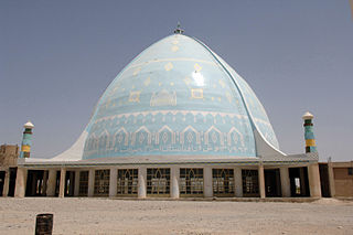
Kandahar is a city in Afghanistan, located in the south of the country on Arghandab River, at an elevation of 1,010 m (3,310 ft). It is Afghanistan's second largest city, after Kabul, with a population of about 614,118. It is the capital of Kandahar Province and the centre of the larger cultural region called Loy Kandahar.

Helmand, also known as Hillmand, in ancient times, as Hermand and Hethumand, is one of the 34 provinces of Afghanistan, in the south of the country. It is the largest province by area, covering 58,584 square kilometres (20,000 sq mi) area. The province contains 18 districts, encompassing over 1,000 villages, and roughly 1,446,230 settled people. Lashkargah serves as the provincial capital. Helmand was part of the Greater Kandahar region until made into a separate province by the Afghan government in the 20th century.

Kandahār is one of the thirty four provinces of Afghanistan, located in the southern part of the country, sharing a border with Pakistan, to the south. It is surrounded by Helmand in the west, Uruzgan in the north and Zabul Province in the east. Its capital is the city of Kandahar, which is Afghanistan's second largest city, which is located on the Arghandab River. The greater region surrounding the province is called Loy Kandahar. The Emir of Afghanistan sends orders to Kabul from Kandahar making it the de facto capital of Afghanistan, although the main government body operates in Kabul. All meetings with the Emir take place in Kandahar, meetings excluding the Emir are in Kabul.
Waziristan is a mountainous region of Pakistani province of Khyber Pakhtunkhwa. The Waziristan region administratively splits among three districts: North Waziristan, Lower South Waziristan District, and Upper South Waziristan District. Waziristan region, consisted of three districts, covers around 11,585 square kilometres (4,500 sq mi) and is mainly populated by the Mehsud, The Wolves, & Wazir Pashtun tribe, who speak the Waziri dialect of the Pashto language.

Lakki Marwat or Lakki is the headquarters of Lakki Marwat District in Khyber Pakhtunkhwa province of Pakistan. Lakki Marwat has become one of the fastest growing cities in Khyber Pakhtunkhwa. Lakki Marwat is also the 20th most populous city in the province of Khyber Pakhtunkhwa.
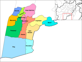
Panjwayi is a district in Kandahar Province, Afghanistan. It is located about 35 kilometres (22 mi) west of Kandahar. The district borders Helmand Province to the southwest, Maywand District to the west, Zhari District to the north, Arghandab, Kandahar and Daman districts to the east and Reg District to the south. Panjwayi was reduced in size in 2004 when Zhari District was created out of the northern part of it, on the northern side of the Arghandab River, which now forms the northern boundary.
Daman District is situated in the central part of the Kandahar Province, Afghanistan. It borders Panjwai and Kandahar districts to the west, Shah Wali Kot District to the north, Zabul Province to the northeast, Arghistan and Spin Boldak districts to the east and Reg District to the south. The population is 30,700 (2006). The center is the village of Daman, located in the central part of the district. The area is irrigated by the Helmand and Arghandab Valley Authority.
Maruf District, also Ma'ruf or Maroof, is a district in Kandahar Province, Afghanistan. It borders Arghistan District to the west, Zabul Province to the north and Pakistan to the east and south. The population was 200,000 in 2006. The district center is the town of Maruf, located in the northern part of the district. It is a boundary mountainous district with many rugged mountain passes towards Pakistan. It is located almost 190 km from any provincial city. This district has 360 villages. It has very agricultural land.

Arghandab is a district in the central part of Kandahar Province, Afghanistan. It borders Panjwai and Khakrez districts to the west, Shah Wali Kot District to the north and east and Kandahar District to the east and south.
Zhari is a district in Kandahar Province, Afghanistan. Alternative spellings include Zheley, Zharey, Zharay, Zheri, or Zheray. The district was created in 2004 from land that was formerly part of Maywand and Panjwai districts. The population is estimated at 80,700 (2010).

Ahmad Shah Baba International Airport, also referred to as Kandahar International Airport, and by some military officials as Kandahar Airfield, KAF), is located in the Daman District of Kandahar Province in Afghanistan, about 9 NM southeast from the city of Kandahar. It serves as the nation's second main international airport and as one of the largest main operating bases, capable of housing up to 250 aircraft of different sizes. The current head of the airport is Maulvi Fathullah Mansour.
The Arghistan District is a district in the northeastern part of Kandahar Province, Afghanistan. It borders Spin Boldak District to the south and west, Daman District to the west, Zabul Province to the north, Maruf District to the east and Pakistan to the south. The population is 30,500 (2006). The district's center is the village of Arghistan, in the physical center of the district in the Arghistan River valley.
Daman is a village and the center of Daman District, Kandahar Province, Afghanistan. It is located at 1037 metres (3402') altitude close to the main road from Kandahar to Kabul, east of Kandahar.

Reg District is located in the southern part of Kandahar Province in Afghanistan. It borders Helmand Province to the west, Panjwai and Daman districts to the north, Shorabak District to the east and Chagai District in Balochistan, Pakistan, to the south.
Shah Wali Kot District is situated in the northern part of Kandahar Province, Afghanistan. It borders Khakrez District to the west, Naish District and Oruzgan Province to the north, Zabul Province to the east and Daman and Arghandab districts to the south. The population is 38,400 (2006). The district center is located in the most southern part of the district. The district has been known as a stronghold of the Taliban forces.
Kandahar District or Dand District is situated in the central part of Kandahar Province, Afghanistan, surrounding the city of Kandahar. It borders Panjwai District to the west, Arghandab District to the north, Shah Wali Kot District to the northeast and Daman District to the east and south. The population is 468,200 (2006). The district center is the city of Kandahar.
The following lists events that happened during 2004 in Afghanistan.
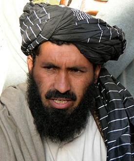
Maulvi Nazir was a leading militant of the Pakistani Taliban in South Waziristan. Nazir's operations were based in Wana.

The Battle of Kandahar began on 9 July 2021, as Taliban insurgents assaulted the city to capture it from the Afghan National Security Forces (ANSF). After heavy fighting for weeks the city's defenses had started to dissolve in August. This allowed the Taliban to enter and overrun most of the city on 12 August 2021, including the Sarposa prison, which included the release of over 1,000 prisoners, and ultimately the capture of the city. However, the siege for the nearby airport continued, where government loyalists held out until being evacuated on 16 August.
1. (pdf) The Helmand Valley Project in Afghanistan: A.I.D. Evaluation Special Study No. 18 C Clapp-Wicek & E Baldwin, U.S. Agency for International Development, published December 1983
