Gray County, Texas

Last updated

Gray County
Gray County Courthouse (Pampa, Texas).JPG
The Gray County Courthouse
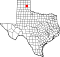
Map of Texas highlighting Gray County.svg
Location within the U.S. state of Texas
Texas in United States.svg
Texas's location within the U.S.
Coordinates: 35°25′N100°49′W / 35.41°N 100.81°W / 35.41; -100.81
CountryFlag of the United States.svg United States
StateFlag of Texas.svg  Texas
Founded1902
Named for Peter W. Gray
Seat Pampa
Largest cityPampa
Area
  Total
929 sq mi (2,410 km2)
  Land926 sq mi (2,400 km2)
  Water3.4 sq mi (9 km2)  0.4%
Population
 (2020)
  Total
21,227 Decrease2.svg
  Density23/sq mi (9/km2)
Time zone UTC−6 (Central)
  Summer (DST) UTC−5 (CDT)
Congressional district 13th
Website www.co.gray.tx.us

Gray County is a county located in the U.S. state of Texas. As of the 2020 census, its population was 21,227. [1] The county seat is Pampa. [2] The county was created in 1876 and later organized in 1902. [3] Gray County is named for Peter W. Gray, [4] a Confederate lawyer and soldier in the American Civil War. Gray County comprises the Pampa, TX micropolitan statistical area.

Contents

Geography

According to the U.S. Census Bureau, the county has a total area of 929 square miles (2,410 km2), of which 926 sq mi (2,400 km2) are land and 3.4 sq mi (8.8 km2) (0.4%) are covered by water. [5]

Major highways

Adjacent counties

National protected area

Demographics

Historical population
CensusPop.Note
1880 56
1890 203262.5%
1900 480136.5%
1910 3,405609.4%
1920 4,66336.9%
1930 22,090373.7%
1940 23,9118.2%
1950 24,7283.4%
1960 31,53527.5%
1970 26,949−14.5%
1980 26,386−2.1%
1990 23,967−9.2%
2000 22,744−5.1%
2010 22,535−0.9%
2020 21,227−5.8%
U.S. Decennial Census [6]
1850–2010 [7] 2010 [8] 2020 [9]
Gray County, Texas – Racial and ethnic composition
Note: the US Census treats Hispanic/Latino as an ethnic category. This table excludes Latinos from the racial categories and assigns them to a separate category. Hispanics/Latinos may be of any race.
Race / Ethnicity (NH = Non-Hispanic)Pop 2000 [10] Pop 2010 [8] Pop 2020 [9] % 2000% 2010% 2020
   White alone (NH)17,80015,56413,02578.26%69.07%61.36%
   Black or African American alone (NH)1,3091,0558355.76%4.68%3.93%
   Native American or Alaska Native alone (NH)1691521410.74%0.67%0.66%
Asian alone (NH)88831270.39%0.37%0.60%
Pacific Islander alone (NH)4100.02%0.00%0.00%
Other race alone (NH)1811370.08%0.05%0.17%
Mixed race or Multiracial (NH)3973047151.75%1.35%3.37%
Hispanic or Latino (any race)2,9595,3656,34713.01%23.81%29.90%
Total22,74422,53521,227100.00%100.00%100.00%

As of the census [11] of 2000, 22,744 people, 8,793 households, and 6,049 families were residing in the county. The population density was 24 people per square mile (9.3 people/km2). The 10,567 housing units averaged 11 units per square mile (4.2/km2). The racial makeup of the county was 82.15% White, 5.85% African American, 0.94% Native American, 0.39% Asian, 8.25% from other races, and 2.42% from two or more races. About 13.01% of the population was Hispanic or Latino of any race.

Of the 8,793 households, 30.00% had children under the age of 18 living with them, 57.00% were married couples living together, 9.00% had a female householder with no husband present, and 31.20% were not families. About 28.70% of all households were made up of individuals, and 15.30% had someone living alone who was 65 years of age or older. The average household size was 2.39, and the average family size was 2.93.

In the county, the age distribution was 24.00% under 18, 8.40% from 18 to 24, 27.20% from 25 to 44, 22.30% from 45 to 64, and 18.10% who were 65 or older. The median age was 39 years. For every 100 females, there were 104.00 males. For every 100 females age 18 and over, there were 103.70 males.

The median income for a household in the county was $31,368, and for a family was $40,019. Males had a median income of $32,401 versus $20,158 for females. The per capita income for the county was $16,702. About 11.20% of families and 13.80% of the population were below the poverty line, including 17.60% of those under age 18 and 9.60% of those age 65 or over.

Communities

City

Towns

Census-designated place

Other unincorporated communities

Politics

Prior to 1952, Gray County was primarily Democratic similar to most of Texas and the Solid South. The county only gave a Republican presidential candidate a majority before 1952 in 1928, when Herbert Hoover won the county due to anti-Catholic sentiment towards Al Smith. Starting with the 1952 election, the county has become a Republican stronghold along with the rest of the Texas Panhandle. This level of Republican dominance has increased in recent years, as every Republican presidential candidate in the second millennium has racked up 80% of the county's vote. Additionally, after the 2008 election, Democrats Barack Obama, Hillary Clinton, and Joe Biden have failed to win even 1,000 votes total in the county.

United States presidential election results for Gray County, Texas [12]
Year Republican Democratic Third party(ies)
No.%No.%No.%
2024 6,69188.27%84511.15%440.58%
2020 6,84087.90%82910.65%1131.45%
2016 6,50087.78%7019.47%2042.75%
2012 6,44387.20%88611.99%600.81%
2008 6,92485.13%1,15314.18%560.69%
2004 7,26084.69%1,28915.04%230.27%
2000 6,73282.25%1,37616.81%770.94%
1996 6,10269.15%2,11423.96%6086.89%
1992 6,10558.86%2,42623.39%1,84117.75%
1988 7,25974.22%2,46025.15%620.63%
1984 8,95581.50%2,00318.23%300.27%
1980 7,18770.81%2,78627.45%1761.73%
1976 6,01060.33%3,87238.87%800.80%
1972 7,96884.37%1,36714.47%1091.15%
1968 5,99455.53%2,37421.99%2,42722.48%
1964 5,01157.93%3,63342.00%60.07%
1960 6,19768.76%2,80231.09%140.16%
1956 5,04761.90%3,03437.21%720.88%
1952 5,46761.73%3,36738.02%230.26%
1948 1,59427.98%3,69964.94%4037.08%
1944 1,73934.86%3,06761.48%1833.67%
1940 1,21721.97%4,31577.89%80.14%
1936 4649.59%4,34789.83%280.58%
1932 50512.70%3,44686.69%240.60%
1928 1,87165.35%98634.44%60.21%
1924 58148.86%60851.14%00.00%
1920 25130.95%52965.23%313.82%
1916 6911.73%48281.97%376.29%
1912 133.09%27264.61%13632.30%

Notable people

See also

Related Research Articles

<span class="mw-page-title-main">Clay County, Texas</span> County in Texas, United States

Clay County is a county located in the U.S. state of Texas. As of the 2020 census, its population was 10,218. The county seat is Henrietta. The county was founded in 1857 and later organized in 1860. It is named in honor of Henry Clay, famous American statesman, Kentucky Senator and United States Secretary of State. Clay County is part of the Wichita Falls, Metropolitan Statistical Area in North Texas.

<span class="mw-page-title-main">Zapata County, Texas</span> County in Texas, United States

Zapata County is a county located in the U.S. state of Texas. As of the 2020 census, its population was 13,889. Its county seat is Zapata. The county is east of the Mexico–United States border and is named for Colonel José Antonio de Zapata, a rancher in the area who rebelled against Mexico.

<span class="mw-page-title-main">Wheeler County, Texas</span> County in Texas, United States

Wheeler County is a county located in the U.S. state of Texas. As of the 2020 census, its population was 4,990. Its county seat is Wheeler. The county was formed in 1876 and organized in 1879. It is named for Royall Tyler Wheeler, a chief justice of the Texas Supreme Court.

<span class="mw-page-title-main">San Jacinto County, Texas</span> County in Texas, United States

San Jacinto County is a county in the U.S. state of Texas. As of the 2020 census, its population was 27,402. Its county seat is Coldspring. The county's name comes from the Battle of San Jacinto which secured Texas' independence from Mexico and established a republic in 1836.

<span class="mw-page-title-main">San Augustine County, Texas</span> County in Texas, United States

San Augustine County is a county located in the U.S. state of Texas. As of the 2020 census, its population was 7,918. Its county seat is San Augustine.

<span class="mw-page-title-main">Oldham County, Texas</span> County in Texas, United States

Oldham County is a county located in the U.S. state of Texas. As of the 2020 census, its population was 1,758. Its county seat is Vega. The county was created in 1876 and organized in 1881. Oldham County is included in the Amarillo, TX Metropolitan Statistical Area.

<span class="mw-page-title-main">Lipscomb County, Texas</span> County in Texas, United States

Lipscomb County is a county located in the U.S. state of Texas. As of the 2020 census, its population was 3,059. Its county seat is Lipscomb. The county was created in 1876 and organized in 1887. It is named for Judge Abner Smith Lipscomb, a secretary of state of the Republic of Texas.

<span class="mw-page-title-main">Leon County, Texas</span> County in Texas, United States

Leon County is a county in the U.S. state of Texas. As of the 2020 census, its population was 15,719. Its county seat is Centerville.

<span class="mw-page-title-main">Hood County, Texas</span> County in Texas, United States

Hood County is a county in the U.S. state of Texas. As of the 2020 census, the population was 61,598. Its county seat is Granbury. The county is named for John Bell Hood, a Confederate lieutenant general and the commander of Hood's Texas Brigade.

<span class="mw-page-title-main">Hemphill County, Texas</span> County in Texas, United States

Hemphill County is a county located in the U.S. state of Texas. As of the 2020 census, its population was 3,382. The county seat and only incorporated community in the county is the city of Canadian. The county was created in 1876 and organized in 1887. It is named for John Hemphill, a judge and Confederate congressman. Hemphill County is the most recent Texas county to permit alcohol sales.

<span class="mw-page-title-main">Hartley County, Texas</span> County in Texas, United States

Hartley County is a county located in the U.S. state of Texas. As of the 2020 census, its population was 5,382. The county seat is Channing. The county was created in 1876 and later organized in 1891. It is named for Oliver C. Hartley and his brother, Rufus K. Hartley, two early Texas legislators and lawyers.

<span class="mw-page-title-main">Hall County, Texas</span> County in Texas, United States

Hall County is a county located in the U.S. state of Texas. As of the 2020 census, the population is 2,825. Its county seat is Memphis. The county was created in 1876 and later organized in 1890. It is named for Warren D. C. Hall, a secretary of war for the Republic of Texas.

<span class="mw-page-title-main">Glasscock County, Texas</span> County in Texas, United States

Glasscock County is a county located in the U.S. state of Texas. As of the 2020 census, its population was 1,169. Its county seat is Garden City. The county was created in 1827 and later organized in 1869. It is named for George Washington Glasscock, an early settler of the Austin, Texas area and the namesake of Georgetown, Texas.

<span class="mw-page-title-main">Frio County, Texas</span> County in Texas, United States

Frio County is a county located in the U.S. state of Texas. As of the 2020 census, its population was 18,385. The county seat is Pearsall. The county was created in 1858 and later organized in 1871. Frio is named for the Frio River, whose name is Spanish for "cold".

<span class="mw-page-title-main">Donley County, Texas</span> County in Texas, United States

Donley County is a county located in the U.S. state of Texas. As of the 2020 census, its population was 3,258. Its county seat is Clarendon. The county was created in 1876 and later organized in 1882.

<span class="mw-page-title-main">Cottle County, Texas</span> County in Texas, United States

Cottle County is a county in the U.S. state of Texas. As of the 2020 census, its population was 1,380. Its county seat is Paducah. The county was founded in 1876 and later organized in 1892. It is named for George Washington Cottle, who died defending the Alamo. Cottle County was formerly one of 46 prohibition, or entirely dry counties in the state of Texas. It now allows beer and wine sales.

<span class="mw-page-title-main">Collingsworth County, Texas</span> County in Texas, United States

Collingsworth County is a county in the U.S. state of Texas. As of the 2020 census, its population was 2,652. Its county seat is Wellington. The county was created in 1876 and later organized in 1890. It is named for James Collinsworth, a signer of the Texas Declaration of Independence and first chief justice of the Republic of Texas. Collingsworth County was one of 30 prohibition, or entirely dry, counties in Texas, but a vote in 2017 changed this law.

<span class="mw-page-title-main">Childress County, Texas</span> County in Texas, United States

Childress County is a county located in the U.S. state of Texas. As of the 2020 census, its population was 6,664. The county seat is Childress. The county was created in 1876 and later organized in 1887. It is named for George Campbell Childress, the author of the Texas Declaration of Independence.

<span class="mw-page-title-main">Chambers County, Texas</span> County in Texas, United States

Chambers County is a county in the U.S. state of Texas. As of the 2020 census, its population was 46,571. The county seat is Anahuac. Chambers County is one of the nine counties that comprise Greater Houston, the Houston–The Woodlands–Sugar Land metropolitan statistical area.

<span class="mw-page-title-main">Austin County, Texas</span> County in Texas, United States

Austin County is a rural, agricultural dominated county in the U.S. state of Texas. As of the 2020 census, the population was 30,167. Its seat is Bellville. The county and region was settled primarily by German emigrants in the 1800s.

References

  1. "Gray County, Texas". United States Census Bureau . Retrieved January 30, 2022.
  2. "Find a County". National Association of Counties. Archived from the original on May 31, 2011. Retrieved June 7, 2011.
  3. "Texas: Individual County Chronologies". Texas Atlas of Historical County Boundaries. The Newberry Library. 2008. Archived from the original on April 12, 2017. Retrieved May 23, 2015.
  4. Gannett, Henry (1905). The Origin of Certain Place Names in the United States. Govt. Print. Off. pp.  142.
  5. "2010 Census Gazetteer Files". United States Census Bureau. August 22, 2012. Retrieved April 27, 2015.
  6. "Decennial Census of Population and Housing by Decades". US Census Bureau.
  7. "Texas Almanac: Population History of Counties from 1850–2010" (PDF). Texas Almanac. Archived (PDF) from the original on October 9, 2022. Retrieved April 27, 2015.
  8. 1 2 "P2 Hispanic or Latino, and Not Hispanic or Latino by Race – 2010: DEC Redistricting Data (PL 94-171) – Gray County, Texas". United States Census Bureau .
  9. 1 2 "P2 Hispanic or Latino, and Not Hispanic or Latino by Race – 2020: DEC Redistricting Data (PL 94-171) – Gray County, Texas". United States Census Bureau .
  10. "P004: Hispanic or Latino, and Not Hispanic or Latino by Race – 2000: DEC Summary File 1 – Gray County, Texas". United States Census Bureau.
  11. "U.S. Census website". United States Census Bureau . Retrieved May 14, 2011.
  12. Leip, David. "Dave Leip's Atlas of U.S. Presidential Elections". uselectionatlas.org. Retrieved April 10, 2018.
  13. "Phil Cates". Texas Legislative Reference Library. Retrieved June 29, 2015.

35°25′N100°49′W / 35.41°N 100.81°W / 35.41; -100.81