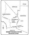
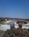
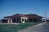
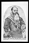
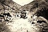
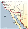
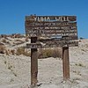
Image [ 1] Landmark name Location City or town Summary Camp Pilot Knob 985 Camp Pilot Knob Sidewinder Rd. 32°45′03″N 114°45′17″W / 32.75095°N 114.7548°W / 32.75095; -114.7548 (Camp Pilot Knob ) Felicity Part of the Desert Training Center , California-Arizona Maneuver Area, Established by Major General George S. Patton, Jr. (#985) Camp Salvation 808 Camp Salvation Rockwood Plaza, 6th St E. & Heber Ave. 32°40′12″N 115°29′36″W / 32.670017°N 115.49325°W / 32.670017; -115.49325 (Camp Salvation ) Calexico Site is now City Hall of Calexico Charley's World of Lost Art 939.4 Charley's World of Lost Art 32°43′51″N 114°43′37″W / 32.730902°N 114.726877°W / 32.730902; -114.726877 (Charley's World of Lost Art ) Andrade Part of the Twentieth Century Folk Art Environments (#939) Fort Yuma 806 Fort Yuma 350 Picacho Rd. 32°43′54″N 114°36′56″W / 32.731714°N 114.615508°W / 32.731714; -114.615508 (Fort Yuma ) Winterhaven Hernando de Alarcón Expedition 568 Hernando de Alarcón Expedition Algondes Rd. 32°44′15″N 114°43′00″W / 32.737367°N 114.716767°W / 32.737367; -114.716767 (Hernando de Alarcón Expedition ) Winterhaven Mission Puerto de Purísima Concepción 350 Mission Puerto de Purísima Concepción Fort Yuma 32°43′50″N 114°36′56″W / 32.7305833333333°N 114.615616666667°W / 32.7305833333333; -114.615616666667 (Mission Puerto de Purísima Concepción ) Winterhaven Site of former Mission Mountain Springs Station 194 Mountain Springs Station I-8 32°39′33″N 116°05′59″W / 32.659167°N 116.099667°W / 32.659167; -116.099667 (Mountain Springs Station ) Jacumba Picacho Mines 193 Picacho Mines Picacho Rd. 32°58′19″N 114°38′07″W / 32.9719°N 114.635167°W / 32.9719; -114.635167 (Picacho Mines ) Winterhaven Plank Road 845 Plank Road Grays Well Road 32°42′37″N 114°55′22″W / 32.710317°N 114.922783°W / 32.710317; -114.922783 (Plank Road ) Winterhaven Fort Romualdo Pacheco 944 Fort Romualdo Pacheco West bank of New River 32°50′50″N 115°40′58″W / 32.847356°N 115.682806°W / 32.847356; -115.682806 (Fort Romualdo Pacheco ) Imperial Site of former Fort, now present day Imperial Valley College Museum Site of Mission San Pedro y San Pablo de Bicuñer 921 Site of Mission San Pedro y San Pablo de Bicuñer County Rd. S24 32°48′59″N 114°30′54″W / 32.816389°N 114.515°W / 32.816389; -114.515 (Site of Mission San Pedro y San Pablo de Bicuñer ) Bard Site of former Mission Tecolote Rancho Site 1034 Tecolote Rancho Site East Country Hwy & Barbara Worth Rd. 32°48′00″N 115°25′18″W / 32.800136°N 115.421698°W / 32.800136; -115.421698 (Tecolote Rancho Site ) Holtville Harold Bell Wright home Tumco Mines 182 Tumco Mines Gold Rack Ranch Rd. 32°52′55″N 114°51′44″W / 32.8818055555556°N 114.862219444444°W / 32.8818055555556; -114.862219444444 (Tumco Mines ) Ogilby Yuha Well 1008 Yuha Well Eastbound Sunbeam Roadside Rest Area, I-8 32°46′25″N 115°40′13″W / 32.773494°N 115.670153°W / 32.773494; -115.670153 (Yuha Well ) Seeley