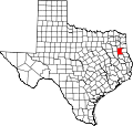
Rusk County | |
---|---|
Coordinates: 32°07′N94°46′W / 32.11°N 94.76°W | |
Country | United States |
State | Texas |
Founded | 1843 |
Named for | Thomas Jefferson Rusk |
Seat | Henderson |
Largest city | Henderson |
Area | |
• Total | 938 sq mi (2,430 km2) |
• Land | 924 sq mi (2,390 km2) |
• Water | 14 sq mi (40 km2) 1.5% |
Population (2020) | |
• Total | 52,214 |
• Density | 56/sq mi (21/km2) |
Time zone | UTC−6 (Central) |
• Summer (DST) | UTC−5 (CDT) |
Congressional district | 1st |
Website | www |
Rusk County is a county located in Texas. As of the 2020 census, its population was 52,214. [1] Its county seat is Henderson. [2] The county is named for Thomas Jefferson Rusk, a secretary of war of the Republic of Texas.
Rusk County is part of the Longview, Texas metropolitan area and the Longview-Marshall combined statistical area.
Prior to Texas' annexation in 1845, the land while from time to time occupied by Caddoan peoples, was generally unpopulated until 1819, when Cherokee Indians, led by The Bowl settled in what is now Rusk County. [3] The Treaty of Bowles Village on February 23, 1836, between the Republic of Texas and the Cherokee and 12 affiliated tribes, gave parts of western Rusk County along with parts of today's Gregg and Van Zandt Counties, in addition to the whole areas of Cherokee and Smith Counties to the tribes. [4] They remained on these lands until the Cherokee War in the summer of 1839. Thus the Cherokee were driven out of Rusk County only to return in 1844 and 1845 with the purchase of 10,000 acres of land by Benjamin Franklin Thompson a white man married to a Cherokee. This established the Mount Tabor Indian Community, [5] some six miles south of present-day Kilgore that later spread to incorporate areas near Troup, Arp and Overton, Texas. Originally organized as a part of Nacogdoches County, Rusk was established as its own county by the Congress of the Republic of Texas on January 16, 1843. By 1850, it was the second-most populous county in Texas of the 78 counties that had been organized at that time, according to the 1850 census. Rusk County's population was 8,148 then; it was surpassed only by Harrison County with 11,822 people.
With the discovery of oil in Joinerville, within the county, in October 1930, an oil boom began that caused county population to nearly double during the next decade, and caused dramatic changes in the county towns. Rusk is one of the five counties that are part of the East Texas Oil Field, whose production has been a major part of the economy since that time. [6]
Rusk County was one of 25 entirely dry counties in Texas until January 2012. The city of Henderson at that time opted to allow selling and serving beer and wine. [7]
America's worst school disaster happened in Rusk County in 1937, when nearly 300 people, most of them children, were killed in a natural gas explosion at the London Independent School District (which has since consolidated into West Rusk County Consolidated Independent School District).
According to the U.S. Census Bureau, the county has a total area of 938 square miles (2,430 km2), of which 14 square miles (36 km2) (1.5%) are covered by water. [8]
Census | Pop. | Note | %± |
---|---|---|---|
1850 | 8,148 | — | |
1860 | 15,803 | 93.9% | |
1870 | 16,916 | 7.0% | |
1880 | 18,986 | 12.2% | |
1890 | 18,559 | −2.2% | |
1900 | 26,099 | 40.6% | |
1910 | 26,946 | 3.2% | |
1920 | 31,689 | 17.6% | |
1930 | 32,484 | 2.5% | |
1940 | 51,023 | 57.1% | |
1950 | 42,348 | −17.0% | |
1960 | 36,421 | −14.0% | |
1970 | 34,102 | −6.4% | |
1980 | 41,382 | 21.3% | |
1990 | 43,735 | 5.7% | |
2000 | 47,372 | 8.3% | |
2010 | 53,330 | 12.6% | |
2020 | 52,214 | −2.1% | |
U.S. Decennial Census [9] 1850–2010 [10] 2010 [11] 2020 [12] |
Race / Ethnicity (NH = Non-Hispanic) | Pop 2000 [13] | Pop 2010 [11] | Pop 2020 [12] | % 2000 | % 2010 | % 2020 |
---|---|---|---|---|---|---|
White alone (NH) | 17,564 | 35,237 | 32,022 | 69.63% | 66.07% | 61.33% |
Black or African American alone (NH) | 4,881 | 9,359 | 8,240 | 19.35% | 17.55% | 15.78% |
Native American or Alaska Native alone (NH) | 75 | 199 | 195 | 0.30% | 0.37% | 0.37% |
Asian alone (NH) | 57 | 203 | 231 | 0.23% | 0.38% | 0.44% |
Pacific Islander alone (NH) | 3 | 14 | 18 | 0.01% | 0.03% | 0.03% |
Other Race alone (NH) | 14 | 50 | 162 | 0.06% | 0.09% | 0.31% |
Mixed Race or Multiracial (NH) | 141 | 659 | 1,767 | 0.56% | 1.24% | 3.38% |
Hispanic or Latino (any race) | 2,489 | 7,609 | 9,579 | 9.87% | 14.27% | 18.35% |
Total | 25,224 | 53,330 | 52,214 | 100.00% | 100.00% | 100.00% |
According to the 2000 census, 47,372 people, 17,364 households, and 12,727 families resided in the county. [14] The population density was 51 people per square mile (20 people/km2). The 19,867 housing units averaged 22 units per square mile (8.5/km2). The racial makeup of the county was 74.89% White, 19.21% Black or African American, 0.35% Native American, 0.24% Asian, 0.01% Pacific Islander, 4.22% from other races, and 1.09% from two or more races. About 8.44% of the population was Hispanic or Latino of any race. In 2020, its population was 52,214. [12]
Of the 17,364 households, 32.50% had children under the age of 18 living with them, 58.20% were married couples living together, 11.20% had a female householder with no husband present, and 26.70% were not families. About 24.20% of all households was made up of individuals, and 12.90% had someone living alone who was 65 years of age or older. The average household size was 2.57 and the average family size was 3.05.
In the county, the population was distributed as 24.90% under the age of 18, 8.30% from 18 to 24, 27.80% from 25 to 44, 23.30% from 45 to 64, and 15.60% who were 65 years of age or older. The median age was 38 years. For every 100 females, there were 104.00 males. For every 100 females age 18 and over, there were 103.10 males.
The median income for a household in the county was $32,898, and for a family was $39,185. Males had a median income of $30,956 versus $19,749 for females. The per capita income for the county was $16,674. About 10.90% of families and 14.60% of the population were below the poverty line, including 20.80% of those under age 18 and 13.00% of those age 65 or over.
Rusk County is home to three privately run facilities for state prisoners: the East Texas Multi-Use Facility for treatment of state inmates, privately operated by the Management and Training Corporation; the Bradshaw State Jail, also private, placed in idle status as of August 2020 because of declining populations; [15] and the Billy Moore Correctional Center, also privately run by MTC. [16]
The following school districts serve Rusk County:
|
|
Rusk County's first officially authorized school was the Rusk County Academy. [17]
Rusk County is represented by Bryan Hughes, a Republican from Mineola, Texas, in the Texas State Senator for Senate District 1, which includes Rusk County. Travis Clardy, a Republican from Nacogdoches, is the Texas State Representative for House District 11, which includes Rusk County. Trent Ashby, a Republican from Lufkin who was born in Rusk County in 1972, represents District 57, which includes Angelina and several other mostly rural East Texas counties.
Year | Republican | Democratic | Third party(ies) | |||
---|---|---|---|---|---|---|
No. | % | No. | % | No. | % | |
2020 | 16,534 | 77.34% | 4,629 | 21.65% | 214 | 1.00% |
2016 | 14,675 | 76.70% | 3,935 | 20.57% | 524 | 2.74% |
2012 | 13,924 | 75.08% | 4,451 | 24.00% | 171 | 0.92% |
2008 | 13,646 | 72.89% | 4,983 | 26.62% | 93 | 0.50% |
2004 | 13,390 | 72.99% | 4,899 | 26.71% | 55 | 0.30% |
2000 | 11,611 | 69.81% | 4,841 | 29.10% | 181 | 1.09% |
1996 | 8,423 | 54.22% | 5,988 | 38.55% | 1,123 | 7.23% |
1992 | 7,560 | 45.61% | 5,391 | 32.53% | 3,623 | 21.86% |
1988 | 9,117 | 63.70% | 5,140 | 35.91% | 56 | 0.39% |
1984 | 11,081 | 70.40% | 4,599 | 29.22% | 61 | 0.39% |
1980 | 8,705 | 60.17% | 5,582 | 38.58% | 180 | 1.24% |
1976 | 6,800 | 52.65% | 6,063 | 46.95% | 52 | 0.40% |
1972 | 8,179 | 73.87% | 2,867 | 25.89% | 26 | 0.23% |
1968 | 3,739 | 29.80% | 4,078 | 32.50% | 4,729 | 37.69% |
1964 | 5,488 | 45.61% | 6,528 | 54.25% | 17 | 0.14% |
1960 | 6,001 | 55.36% | 4,390 | 40.50% | 449 | 4.14% |
1956 | 5,140 | 59.96% | 3,381 | 39.44% | 52 | 0.61% |
1952 | 5,634 | 49.68% | 5,694 | 50.21% | 12 | 0.11% |
1948 | 1,294 | 17.55% | 4,322 | 58.60% | 1,759 | 23.85% |
1944 | 637 | 9.31% | 5,232 | 76.45% | 975 | 14.25% |
1940 | 704 | 8.17% | 7,901 | 91.73% | 8 | 0.09% |
1936 | 433 | 6.61% | 6,107 | 93.27% | 8 | 0.12% |
1932 | 483 | 8.68% | 5,074 | 91.16% | 9 | 0.16% |
1928 | 1,033 | 37.36% | 1,732 | 62.64% | 0 | 0.00% |
1924 | 651 | 17.06% | 3,097 | 81.18% | 67 | 1.76% |
1920 | 745 | 26.02% | 1,555 | 54.31% | 563 | 19.66% |
1916 | 521 | 20.29% | 1,849 | 72.00% | 198 | 7.71% |
1912 | 488 | 21.86% | 1,453 | 65.10% | 291 | 13.04% |
Upshur County is a county located in the eastern part of the U.S. state of Texas. As of the 2020 census, the population was 40,892. The county seat is Gilmer. The county is named for Abel P. Upshur, who was U.S. Secretary of State during President John Tyler's administration.
Smith County is a county in the U.S. state of Texas. As of the 2020 census, its population was 233,479. Its county seat is Tyler. Smith County is named for James Smith, a general during the Texas Revolution. Smith County is part of the Tyler metropolitan statistical area and the Tyler–Jacksonville combined statistical area.
Nacogdoches County is a county located in the U.S. state of Texas. As of the 2020 census, its population was 64,653. Its county seat is Nacogdoches.
Henderson County is a county in the U.S. state of Texas. As of the 2020 census, its population was 82,150. The county seat is Athens. The county is named in honor of James Pinckney Henderson, the first attorney general of the Republic of Texas, and secretary of state for the republic. He later served as the first governor of Texas. Henderson County was established in 1846, the year after Texas gained statehood. Its first town was Buffalo, laid out in 1847. Henderson County comprises the Athens micropolitan statistical area, which is also included in the Dallas-Fort Worth combined statistical area.
Gregg County is a county located in the eastern part of the U.S. state of Texas. As of the 2020 census, its population was 124,239. Its county seat is Longview. The county is named after John Gregg, a Confederate general killed in action during the American Civil War.
Cherokee County is a county located in the U.S. state of Texas. As of the 2020 census, its population was 50,412. The county seat is Rusk, which lies 130 miles southeast of Dallas and 160 miles north of Houston. The county was named for the Cherokee, who lived in the area before being expelled in 1839. Cherokee County comprises the Jacksonville micropolitan statistical area, which is also included in the Tyler–Jacksonville combined statistical area.
Angelina County is a county located in the U.S. state of Texas. It is in East Texas and its county seat is Lufkin.
Rusk is a city in and the county seat of Cherokee County, Texas, United States. At the 2020 United States census, it had a population of 5,285.
Lakeport is a city in Gregg County, Texas, United States. The population was 974 at the 2010 census, up from 861 at the 2000 census; in 2020, its population was 976.
Henderson is a city and the county seat of Rusk County, Texas, in Northeast Texas, United States. Its population was 13,271 at the 2020 census. Henderson is named for James Pinckney Henderson, the first governor of Texas.
Arp is a city in Smith County, in the U.S. state of Texas. It is part of the Tyler metropolitan statistical area. According to the United States Census Bureau. The population was 892 in the 2020 census.
Troup is a city in Smith and Cherokee counties in Texas, United States. Its population was 2,006 at the 2020 census. Troup lies in two counties in East Texas.
Kilgore is a city in Gregg and Rusk counties in Texas, United States. Over three-fourths of the area within city limits are located in Gregg County, the remainder in Rusk County. The population was 12,975 at the 2010 census and 13,376 at the 2020 census.
Longview is a city in, and county seat of, Gregg County, Texas, United States. Longview is located in East Texas, where Interstate 20 and U.S. highways 80 and 259 converge just north of the Sabine River. According to the 2020 U.S. census, the city had a population of 81,638. Longview is the principal city of the Longview metropolitan statistical area, comprising Gregg, Upshur, and Rusk counties. The population of the metropolitan area as of 2021 census estimates was 287,858.
Overton is a city in Rusk and Smith counties in the U.S. state of Texas. Overton lies in two counties as well as two metropolitan areas. The Rusk County portion of the city is part of the Longview Metropolitan Statistical Area, while the Smith County portion is part of the Tyler Metropolitan Statistical Area.
East Texas is a broadly defined cultural, geographic, and ecological region in the eastern part of the U.S. state of Texas that comprises most of 41 counties. It is primarily divided into Northeast and Southeast Texas. Most of the region consists of the Piney Woods ecoregion. East Texas can sometimes be defined only as the Piney Woods. At the fringes, towards Central Texas, the forests expand outward toward sparser trees and eventually into open plains.
Northeast Texas is a cultural and geographic region in the northeast corner of the U.S. state of Texas. Geographically centered on two metropolitan areas strung along Interstate 20—Tyler in the west and Longview/Marshall to the east, the areas of Greenville, Mount Pleasant, Sulphur Springs, Paris, and Texarkana in the north primarily along Interstate 30, and Jacksonville and Palestine to the south are also major cities within the region. Most of Northeast Texas is included in the interstate region of the Ark-La-Tex.
The Longview–Marshall Combined Statistical Area covered four counties in Northeast Texas. The statistical area consists of the Longview Metropolitan Statistical Area and the Marshall Micropolitan Statistical Area. Prior to 2003, the area was known as the Longview–Marshall Metropolitan Statistical Area, which consisted of Gregg, Harrison, Rusk, and Upshur counties. As of the 2000 census, the CSA had a population of 256,152. In 2023, the Marshall micropolitan area was removed, and Harrison County was combined into the Longview metropolitan area.
The Longview metropolitan statistical area is a metropolitan area in Northeast Texas that covers four counties—Gregg, Harrison, Rusk, and Upshur. As of the 2010 census the MSA had a population of 280,000. Before 2023, it was also part of the larger Longview–Marshall combined statistical area. In 2023, the Marshall micropolitan area was disestablished and its sole county, Harrison County, was made part of the Longview metropolitan area.
Lake Cherokee is an unincorporated community and census-designated place (CDP) in Gregg and Rusk counties, Texas, United States. Its population was 2,980 as of the 2020 census. Lake Cherokee is located 12 miles southeast of Gregg and northeastern Rusk counties on Cherokee Bayou. The lake is owned by the Cherokee Water Company to supply water for municipal, industrial, and recreational purposes. It has a capacity of 68,700 acre-feet. The lake impounds Cherokee Bayou. The top of the dam is at the elevation of 295 feet above the average sea level, but it has a max design of 291 feet above the average sea level.