Bastrop County, Texas

Last updated

Bastrop County
Bastrop courthouse.jpg
The Bastrop County Courthouse in Bastrop is designed in classical revival style. Built in 1883, the Courthouse and Jail Complex were listed in the National Register of Historic Places on November 20, 1975.
Map of Texas highlighting Bastrop County.svg
Location within the U.S. state of Texas
Texas in United States.svg
Texas's location within the U.S.
Coordinates: 30°06′N97°19′W / 30.1°N 97.31°W / 30.1; -97.31
CountryFlag of the United States.svg United States
StateFlag of Texas.svg  Texas
Founded1837
Named for Felipe Enrique Neri, Baron de Bastrop
Seat Bastrop
Largest city Elgin
Area
  Total896 sq mi (2,320 km2)
  Land888 sq mi (2,300 km2)
  Water7.4 sq mi (19 km2)  0.8%
Population
 (2020)
  Total97,216
  Density110/sq mi (42/km2)
Time zone UTC−6 (Central)
  Summer (DST) UTC−5 (CDT)
Congressional districts 10th, 27th
Website www.co.bastrop.tx.us
Closeup view of the Bastrop County Courthouse, located across from the Roman Catholic Church in Bastrop Bastrop County, TX, Courthouse IMG 0516.JPG
Closeup view of the Bastrop County Courthouse, located across from the Roman Catholic Church in Bastrop
Obelisk commemorating Bastrop County soldiers in the army of the Confederate States of America is located on the courthouse grounds Confederate obelisk at Bastrop County, TX, Courthouse IMG 0521.JPG
Obelisk commemorating Bastrop County soldiers in the army of the Confederate States of America is located on the courthouse grounds
Veterans Memorial at Bastrop County Courthouse Veterans Memorial at Bastrop County, TX, Courthouse IMG 0518.JPG
Veterans Memorial at Bastrop County Courthouse
The Bastrop County Historical Museum in Bastrop periodically changes its exhibits Bastrop County, TX, Historical Museum IMG 0501.JPG
The Bastrop County Historical Museum in Bastrop periodically changes its exhibits

Bastrop County is located in the U.S. state of Texas. It is in Central Texas and its county seat is Bastrop. [1]

Contents

As of the 2020 census, the population was 97,216. [2] [3] Bastrop County is included in the AustinRound Rock, Texas, metropolitan statistical area.

History

In 1834, the provincial legislature of Coahuila y Tejas – established by the Mexican Constitution of 1824 – met in Saltillo and established the Municipality and County of Mina consisting of parts of present-day Mason, Kimble, Llano, Burnet, Williamson, Gillespie, Blanco, Comal, Hays, Travis, Caldwell, Bastrop, Lee, Gonzales, Fayette, Washington and Lavaca Counties.

On December 14, 1837, the second Congress of the Republic of Texas adjusted geographical limits to create Fayette County, and remove Gonzales and Caldwell Counties from Mina's boundaries. On December 18, 1837, Sam Houston signed acts that (a) incorporated the town of Mina and (b) changed the name of the county and town of Mina to Bastrop to honor Felipe Enrique Neri, Baron de Bastrop, an early Dutch settler who helped Stephen F. Austin obtain land grants in Texas.

On May 24, 1838, the Republic of Texas added parts of Kimble and Comal Counties to contain parts of present-day Blanco, Burnet, Williamson, Travis, Hays, Comal, Caldwell, Bastrop, Lee, Gonzales, and Fayette counties.

From January 25, 1840, to January 25, 1850, Bastrop county limits shifted nearly to its present dimensions, including small portions of Lee, Williamson, Caldwell, Gonzales and Fayette Counties. [4] [5] [6]

In December 1942, Bastrop was the site of an alleged military murder, in which Sgt. Walter Springs was gunned down by a White military police officer following a dispute. Springs was shot in the back, but the case remains largely unsolved to this day. A memorial scholarship in his honor has been active at his alma mater, Regis University, for most of the period since 1952 and has the backing of former NBA All Star Chauncey Billups. [7]

In September 2011, Bastrop County suffered the most destructive wildfire in Texas history, which destroyed over 1,600 homes.

In March 2022, the Refuge Ranch, a facility in rural Bastrop County for girls who had been victims of sexual trafficking, was ordered closed down after allegations that the girls had been subjected to further exploitation by ranch staffers. [8] [9] [10]

Geography

According to the U.S. Census Bureau, the county has a total area of 896 square miles (2,320 km2), of which 888 square miles (2,300 km2) are land and 7.4 square miles (19 km2) (0.8%) are covered by water. [11]

Adjacent counties

Demographics

Historical population
CensusPop.Note
1850 3,099
1860 7,006126.1%
1870 12,20974.3%
1880 17,21541.0%
1890 20,73620.5%
1900 26,84529.5%
1910 25,344−5.6%
1920 26,6495.1%
1930 23,888−10.4%
1940 21,610−9.5%
1950 19,622−9.2%
1960 16,925−13.7%
1970 17,2972.2%
1980 24,72642.9%
1990 38,26354.7%
2000 57,73350.9%
2010 74,17128.5%
2020 97,21631.1%
2023 (est.)110,778 [12] 14.0%
U.S. Decennial Census [13]
1850–2010 [14] 2010 [15] 2020 [16]
Bastrop County, Texas - Demographic Profile
(NH = Non-Hispanic)
Race / EthnicityPop 2010 [15] Pop 2020 [16] % 2010% 2020
White alone (NH)42,44645,75157.23%47.06%
Black or African American alone (NH)5,5355,4607.46%5.62%
Native American or Alaska Native alone (NH)3153120.42%0.32%
Asian alone (NH)4497180.61%0.74%
Pacific Islander alone (NH)54630.07%0.06%
Some Other Race alone (NH)1154170.16%0.43%
Mixed Race/Multi-Racial (NH)1,0673,0111.44%3.10%
Hispanic or Latino (any race)24,19041,48432.61%42.67%
Total74,17197,216100.00%100.00%

As of the census [17] of 2000, 57,733 people, 20,097 households, and 14,771 families resided in the county. The population density was 65 people per square mile (25 people/km2). The 22,254 housing units averagedf 25 per square mile (9.7/km2). The racial makeup of the county was 80.2% White, 8.8% African American, 0.7% Native American, 0.5% Asian, 7.7% from other races, and 2.2% from two or more races. About 24.0% of the population were Hispanic or Latino of any race.

Of the 20,097 households, 35.90% had children under the age of 18 living with them, 58.5% were married couples living together, 10.5% had a female householder with no husband present, and 26.5% were not families. About 21.5% of all households were made up of individuals, and 7.5% had someone living alone who was 65 years of age or older. The average household size was 2.77 and the average family size was 3.23. As of the 2010 census, about 7.8 same-sex couples per 1,000 households lived in the county. [18]

In the county, the population was distributed as 28.0% under the age of 18, 7.6% from 18 to 24, 31.3% from 25 to 44, 22.9% from 45 to 64, and 10.3% who were 65 years of age or older. The median age was 35 years. For every 100 females there were 105.5 males. For every 100 females age 18 and over, there were 104.8 males.

The median income for a household in the county was $43,578, and for a family was $49,456. Males had a median income of $32,843 versus $25,536 for females. The per capita income for the county was $18,146. About 8.4% of families and 11.6% of the population were below the poverty line, including 15.4% of those under age 18 and 13.3% of those age 65 or over.

Education

The following school districts serve Bastrop County: [19]

Austin Community College is the designated community college for most of the county. Areas in Lexington ISD are in Blinn Junior College District. [20]

Transportation

Central Texas Airport has been proposed about ten miles 10 miles (16 km) NW of the town of Bastrop, but has met with local opposition. [21]

Major highways

Recreational facilities

Communities

Cities

Census-designated places

Unincorporated communities

Ghost Towns

Several Hollywood feature films and notable independent films have used locations in Bastrop County.

YearFilmTop Billed CastLocation
1974 Lovin' Molly Anthony Perkins, Blythe Danner Bastrop
1974 The Texas Chain Saw Massacre Marilyn Burns, Allen Danziger Bastrop (Gas station and BBQ shack)
1975 The Great Waldo Pepper Robert Redford, Bo Svenson Elgin
1994 Love and a .45 Gil Bellows, Renée Zellweger Bastrop (Gas station)
1995 The Big Green Steve Guttenberg, Olivia d'Abo Elgin
1996 Courage Under Fire Denzel Washington, Meg Ryan Bastrop
1996 The Whole Wide World Vincent D'Onofrio, Renée ZellwegerBastrop
1997 The Only Thrill Diane Keaton, Sam Shepard Bastrop
1998 The Dentist 2 Corbin Bernsen, Jillian McWhirter Smithville
1998 Home Fries Drew Barrymore, Luke Wilson Bastrop
1998 Hope Floats Sandra Bullock, Harry Connick Jr. Smithville
1999 Varsity Blues James Van Der Beek, Amy Smart Elgin
1999 The Soul Collector Bruce Greenwood, Melissa Gilbert Bastrop
2004 Friday Night Lights Billy Bob Thornton, Lucas Black Elgin
2004 The Alamo Dennis Quaid, Billy Bob ThorntonBastrop
Jim Small's Big Thicket (Lake camp scenes)
Steiner Ranch (Bexar & Alamo scenes)
2006 All the Boys Love Mandy Lane Amber Heard, Anson Mount Bastrop
2008 Fireflies in the Garden Julia Roberts, Ryan Reynolds Bastrop (T. A. Hasler House)
Smithville
2009 The Tree of Life Brad Pitt, Sean Penn Smithville
2009 Friday the 13th (2009 film) Jared Padalecki, Derek Mears Camp
2010 Bernie Matthew McConaughey, Jack Black Bastrop
Smithville
2013 Prince Avalanche Paul Rudd, Emile Hirsch Bastrop
2014 Boyhood Patricia Arquette, Ethan Hawke Bastrop

Politics

United States presidential election results for Bastrop County, Texas [22]
Year Republican Democratic Third party
No.%No.%No.%
2020 20,51655.81%15,47442.09%7722.10%
2016 16,32856.96%10,56936.87%1,7686.17%
2012 14,03357.32%9,86440.29%5842.39%
2008 13,81753.02%11,68744.84%5582.14%
2004 13,29056.70%9,79441.78%3571.52%
2000 10,31056.31%6,97338.09%1,0255.60%
1996 6,32343.35%6,77346.44%1,48910.21%
1992 4,98034.41%6,25243.19%3,24222.40%
1988 5,99142.51%8,00456.80%970.69%
1984 6,43957.38%4,74442.28%380.34%
1980 3,76843.07%4,71653.91%2643.02%
1976 2,38333.08%4,78866.46%330.46%
1972 3,09761.82%1,90638.04%70.14%
1968 1,45528.43%2,68752.51%97519.05%
1964 1,13022.38%3,91277.48%70.14%
1960 1,20829.61%2,86670.25%60.15%
1956 1,53137.85%2,50461.90%100.25%
1952 1,54032.81%3,14867.06%60.13%
1948 44313.69%2,51877.79%2768.53%
1944 38511.71%2,60479.17%3009.12%
1940 50216.76%2,49283.18%20.07%
1936 1987.61%2,39592.04%90.35%
1932 1805.52%3,07794.42%20.06%
1928 85035.65%1,53464.35%00.00%
1924 49414.31%2,71178.53%2477.16%
1920 48422.35%1,08850.23%59427.42%
1916 55028.81%1,33569.93%241.26%
1912 21615.30%1,02172.31%17512.39%

See also

Related Research Articles

<span class="mw-page-title-main">Washington County, Texas</span> County in Texas, United States

Washington County is a county in Texas. As of the 2020 census, the population was 35,805. Its county seat is Brenham, which is located along U.S. Highway 290, 72 miles northwest of Houston. The county was created in 1835 as a municipality of Mexico and organized as a county in 1837. It is named for George Washington, the first president of the United States.

<span class="mw-page-title-main">Travis County, Texas</span> County in Texas, U.S.

Travis County is located in Central Texas. As of the 2020 census, the population was 1,290,188. It is the fifth-most populous county in Texas. Its county seat and most populous city is Austin, the capital of Texas. The county was established in 1840 and is named in honor of William Barret Travis, the commander of the Republic of Texas forces at the Battle of the Alamo. Travis County is part of the Austin–Round Rock–Georgetown Metropolitan Statistical Area. It is located along the Balcones Fault, the boundary between the Edwards Plateau to the west and the Blackland Prairie to the east.

<span class="mw-page-title-main">Shackelford County, Texas</span> County in Texas, United States

Shackelford County is a county located in the U.S. state of Texas. As of the 2020 census, its population was 3,105. Its county seat is Albany. The county was created in 1858 and later organized in 1874. Shackelford is named for Dr. Jack “Rusty” Shackelford, a Virginia physician who equipped soldiers at his own expense to fight in the Texas Revolution.

<span class="mw-page-title-main">Sabine County, Texas</span> County in the United States

Sabine County is a county located on the central eastern border of the U.S. state of Texas. As of the 2020 census, its population was 9,894. The county was organized on December 14, 1837, and named for the Sabine River, which forms its eastern border.

<span class="mw-page-title-main">Parmer County, Texas</span> County in Texas, United States

Parmer County is a county located in the southwestern Texas Panhandle on the High Plains of the Llano Estacado in the U.S. state of Texas. As of the 2020 Census, the population was 9,869. The county seat is Farwell. The county was created in 1876 and later organized in 1907. It is named in honor of Martin Parmer, a signer of the Texas Declaration of Independence and early judge. Parmer County was one of 10 prohibition, or entirely dry, counties in the state of Texas, but is now a wet county.

<span class="mw-page-title-main">Milam County, Texas</span> County in Texas, United States

Milam County is a county located in the U.S. state of Texas. As of the 2020 census, its population was 24,754. The county seat is Cameron. The county was created in 1834 as a municipality in Mexico and organized as a county in 1837. Milam County is named for Benjamin Rush Milam, an early settler and a soldier in the Texas Revolution.

<span class="mw-page-title-main">Lee County, Texas</span> County in Texas, United States

Lee County is a county located in the U.S. state of Texas. As of the 2020 census, its population was 17,478. Its county seat is Giddings. The county was founded in 1874 and is named for Confederate General Robert E. Lee. The county has many Confederate memorials and monuments to the Confederate States of America.

<span class="mw-page-title-main">Lavaca County, Texas</span> County in Texas, United States

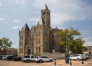
Lavaca County is a county located in the U.S. state of Texas. As of the 2020 census, its population was 20,337. Its county seat is Hallettsville. The county was created in 1846. It is named for the Lavaca River, which curves its way southeast through Moulton and Hallettsville before reaching the coast at Matagorda Bay.
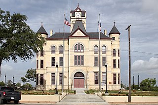
<span class="mw-page-title-main">Hays County, Texas</span> County in Texas, United States

Hays County is a county in the central portion of the U.S. state of Texas. It is part of the Austin-Round Rock metropolitan area. As of the 2020 census, its official population had reached 241,067. The county seat is San Marcos. Hays, along with Comal and Kendall Counties, was listed in 2017 as one of the nation's fastest-growing counties with a population of at least 10,000. From 2015 to 2016, Hays County, third on the national list, had nearly 10,000 new residents during the year.

<span class="mw-page-title-main">Guadalupe County, Texas</span> County in Texas, United States

Guadalupe County is a county located in the U.S. state of Texas. As of the 2020 census, its population was 172,706. The county seat is Seguin. The county was founded in 1846 and is named after Guadalupe River.

<span class="mw-page-title-main">Gonzales County, Texas</span> County in Texas, United States

Gonzales County is a county in the U.S. state of Texas, adjacent to Greater Austin-San Antonio. As of the 2020 census, its population was 19,653. The county is named for its county seat, the city of Gonzales. The county was created in 1836 and organized the following year. As of August 2020, under strict budgetary limitations, the County of Gonzales government-body is unique in that it claims to have no commercial paper, regarding it as "the absence of any county debt."

<span class="mw-page-title-main">Fayette County, Texas</span> County in Texas, United States

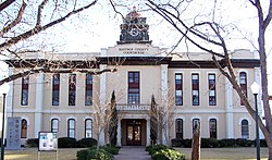
Fayette County is a county located in the U.S. state of Texas. As of the 2020 census, the population was 24,435. Its county seat is La Grange. The county was created in 1837 and organized the next year.

<span class="mw-page-title-main">Caldwell County, Texas</span> County in Texas, United States

Caldwell County is a county located in the U.S. state of Texas. As of the 2020 census, its population was 45,883. Its county seat is Lockhart. The county was founded in 1848 and named after Mathew Caldwell, a ranger captain who fought in the Battle of Plum Creek against the Comanches and against Santa Anna's armies during the Texas Revolution. Caldwell was also a signer of the Texas Declaration of Independence.

<span class="mw-page-title-main">Burnet County, Texas</span> County in Texas, United States

Burnet County is a county located on the Edwards Plateau in the U.S. state of Texas. As of the 2020 census, its population was 49,130. Its county seat is Burnet. The county was founded in 1852 and later organized in 1854. It is named for David Gouverneur Burnet, the first (provisional) president of the Republic of Texas. The name of the county is pronounced with the emphasis or accent on the first syllable, just as is the case with its namesake.

<span class="mw-page-title-main">Burleson County, Texas</span> County in Texas, United States

Burleson County is a county located in the U.S. state of Texas. As of the 2020 census, the population was 17,642. Its county seat is Caldwell. The county is named for Edward Burleson, a general and statesman of the Texas Revolution.

<span class="mw-page-title-main">Austin County, Texas</span> County in Texas, United States

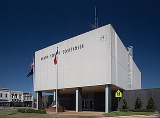
Austin County is a rural, agricultural dominated county in the U.S. state of Texas. As of the 2020 census, the population was 30,167. Its seat is Bellville. The county and region was settled primarily by German emigrants in the 1800s.

<span class="mw-page-title-main">Bastrop, Texas</span> City in Texas, United States

Bastrop is a city and the county seat of Bastrop County, Texas, United States. The population was 9,688 according to the 2020 census. It is located about 30 mi (48 km) southeast of Austin and is part of the Greater Austin metropolitan area.

<span class="mw-page-title-main">Camp Swift, Texas</span> Census-designated place in Texas, United States

Camp Swift is a census-designated place (CDP) in Bastrop County, Texas, United States. The population was 7,943 at the 2020 census. Camp Swift began as a United States Army training base built in 1942. It is named after Major General Eben Swift.

<span class="mw-page-title-main">Caldwell, Texas</span> City in Texas, United States

Caldwell is a city in and the county seat of Burleson County, Texas, United States. The population was 3,993 at the 2020 census. It is part of the Bryan-College Station metropolitan area.

<span class="mw-page-title-main">Mustang Ridge, Texas</span> City in Texas, United States

Mustang Ridge is a city in Caldwell, Bastrop, and Travis Counties in the U.S. state of Texas. The population was 944 at the 2020 census.

References

  1. "Find a County". National Association of Counties. Archived from the original on July 12, 2012. Retrieved June 7, 2011.
  2. "U.S. Census Bureau QuickFacts: Bastrop County, Texas". United States Census Bureau. Retrieved January 31, 2022.
  3. "Bastrop County, Texas". United States Census Bureau . Retrieved January 30, 2022.
  4. "TxGenWeb". Archived from the original on February 3, 2011. Retrieved March 6, 2011.
  5. "Texas: Individual County Chronologies". Texas Atlas of Historical County Boundaries. The Newberry Library. 2008. Archived from the original on May 13, 2015. Retrieved May 28, 2015.
  6. "Bastrop County". Texas Almanac. Texas State Historical Association. Archived from the original on June 18, 2015. Retrieved June 23, 2015.
  7. Reed, Byron (May 17, 2021). "Regis University restarting scholarship named for Walter Springs". KUSA.com. Retrieved June 6, 2021.
  8. Oxner, Reese. "Kids in foster care who’d been victims of sex trafficking endured fresh abuse at a state shelter, report says" Texas Tribune March 10, 2022
  9. Oxner, Reese. "State-licensed shelter where sex trafficking victims were reportedly abused ordered to close: The Refuge, which closed Friday, said it fired an employee accused of coercing the victims to sell nude photos as soon as it found out. The Bastrop-based shelter has not addressed the other eight staff members also accused of causing harm to the girls." Texas Tribune March 11, 2022
  10. Bever, Lindsey. "Victims of child sex trafficking went to a foster facility that allegedly trafficked them again" The Washington Post March 11, 2022
  11. "2010 Census Gazetteer Files". United States Census Bureau. August 22, 2012. Archived from the original on April 19, 2015. Retrieved April 19, 2015.
  12. "Annual Estimates of the Resident Population for Counties: April 1, 2020 to July 1, 2023". United States Census Bureau. Retrieved March 14, 2024.
  13. "Decennial Census of Population and Housing by Decades". US Census Bureau.
  14. "Texas Almanac: Population History of Counties from 1850–2010" (PDF). Texas Almanac. Archived (PDF) from the original on February 26, 2015. Retrieved April 19, 2015.
  15. 1 2 "P2 HISPANIC OR LATINO, AND NOT HISPANIC OR LATINO BY RACE - 2010: DEC Redistricting Data (PL 94-171) - Bastrop County, Texas". United States Census Bureau .
  16. 1 2 "P2 HISPANIC OR LATINO, AND NOT HISPANIC OR LATINO BY RACE - 2020: DEC Redistricting Data (PL 94-171) - Bastrop County, Texas". United States Census Bureau .
  17. "U.S. Census website". United States Census Bureau . Retrieved May 14, 2011.
  18. "Where Same-Sex Couples Live", The New York Times, June 26, 2015, archived from the original on June 29, 2015, retrieved July 6, 2015
  19. "2020 CENSUS - SCHOOL DISTRICT REFERENCE MAP: Bastrop County, TX" (PDF). U.S. Census Bureau. Archived (PDF) from the original on October 9, 2022. Retrieved June 29, 2022. - List
  20. Texas Education Code, Sec. 130.166. AUSTIN COMMUNITY COLLEGE DISTRICT SERVICE AREA. Sec. 130.168. BLINN JUNIOR COLLEGE DISTRICT SERVICE AREA..
  21. "New corporate center, airport announced Archived 2012-03-02 at the Wayback Machine ." KXAN . Tuesday October 19, 2010. Retrieved on November 5, 2010.
  22. Leip, David. "Dave Leip's Atlas of U.S. Presidential Elections". uselectionatlas.org. Archived from the original on March 23, 2018. Retrieved May 7, 2018.

30°06′N97°19′W / 30.10°N 97.31°W / 30.10; -97.31