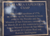
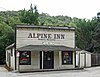
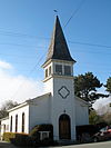
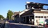
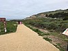
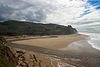
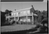
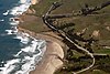
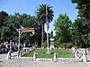
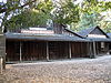
Image [ 1] Landmark name Location City or town Summary Anza Expedition Camp 47 Anza Expedition Camp Banks of San Mateo Creek 37°33′44″N 122°19′44″W / 37.5620861111111°N 122.32885°W / 37.5620861111111; -122.32885 (Anza Expedition Camp ) San Mateo March 29, 1776 camp Anza Expedition Camp 48 Anza Expedition Camp El Camino Real and Ralston 37°34′33″N 122°20′52″W / 37.5759416666667°N 122.347861111111°W / 37.5759416666667; -122.347861111111 (Anza Expedition Camp ) Burlingame March 26, 1776 camp Broderick-Terry Dueling Place 19 Broderick-Terry Dueling Place 1100 Lake Merced Blvd. 37°42′29″N 122°29′03″W / 37.708167°N 122.484167°W / 37.708167; -122.484167 (Broderick-Terry Dueling Place ) Daly City Burlingame Station 846 Burlingame Station 290 California Dr. 37°34′48″N 122°20′42″W / 37.58°N 122.345°W / 37.58; -122.345 (Burlingame Station ) Burlingame Also on the NRHP list as NPS-78000769 Capidro 939.8 Capidro 262 Princeton Rd. 37°26′36″N 122°10′45″W / 37.443254°N 122.179274°W / 37.443254; -122.179274 (Capidro ) Menlo Park Folk art ornamenting a Menlo Park home, no longer exists. Carolands 886 Carolands 565 Remillard Rd. 37°33′20″N 122°22′15″W / 37.5555°N 122.37075°W / 37.5555; -122.37075 (Carolands ) Hillsborough Also on the NRHP list as NPS-75000478 Casa de Tableta 825 Casa de Tableta 3915 Alpine Rd. 37°22′56″N 122°11′37″W / 37.382222°N 122.193611°W / 37.382222; -122.193611 (Casa de Tableta ) Portola Valley Also called Alpine Inn, on the NRHP list as NPS-73000447 Filoli 907 Filoli Filoli Center, Canada Rd. 37°28′13″N 122°18′39″W / 37.4704°N 122.310703°W / 37.4704; -122.310703 (Filoli ) Woodside First Congregational Church of Pescadero 949 First Congregational Church of Pescadero San Gregorio St. 37°15′16″N 122°23′00″W / 37.25455°N 122.383333°W / 37.25455; -122.383333 (First Congregational Church of Pescadero ) Pescadero Menlo Park Station 955 Menlo Park Station 1120 Merrill St. 37°27′17″N 122°10′51″W / 37.454722°N 122.180833°W / 37.454722; -122.180833 (Menlo Park Station ) Menlo Park Also on the NRHP list as NPS-74000556 Mission Hospice 393 Mission Hospice Baywood and El Camino Real 37°33′55″N 122°19′41″W / 37.565383°N 122.328067°W / 37.565383; -122.328067 (Mission Hospice ) San Mateo Mission San Mateo, an outpost for Mission San Francisco de Asis (Dolores), was repurposed as an inn. Buildings no longer exist. Old Store at La Honda 343 Old Store at La Honda Northwest corner, La Honda Road and Sears Ranch Road 37°19′10″N 122°16′29″W / 37.3195611111111°N 122.2747°W / 37.3195611111111; -122.2747 (Old Store at La Honda ) La Honda Building no longer exists. Our Lady of the Wayside Church 909 Our Lady of the Wayside Church 930 Portola Rd. 37°23′02″N 122°14′02″W / 37.3839°N 122.2338°W / 37.3839; -122.2338 (Our Lady of the Wayside Church ) Portola Valley Pigeon Point Lighthouse 930 Pigeon Point Lighthouse 37°10′54″N 122°23′38″W / 37.181667°N 122.393889°W / 37.181667; -122.393889 (Pigeon Point Lighthouse ) Davenport Ohlone-Portolá Heritage Trail, Purisíma Creek 22 Ohlone-Portolá Heritage Trail, Purisíma Creek Mouth of Purisíma Creek 37°24′16″N 122°25′29″W / 37.404579°N 122.42471°W / 37.404579; -122.42471 (Ohlone-Portolá Heritage Trail, Purisíma Creek ) Half Moon Bay October 27, 1769 camp Ohlone-Portolá Heritage Trail at Gazos Creek 23 Ohlone-Portolá Heritage Trail at Gazos Creek Mouth of Gazos Creek 37°09′55″N 122°21′42″W / 37.165375°N 122.361686111111°W / 37.165375; -122.361686111111 (Ohlone-Portolá Heritage Trail at Gazos Creek ) Pescadero October 23, 1769 camp Portolá Expedition Camp 24 Portolá Expedition Camp Mouth of San Pedro Creek 37°35′58″N 122°30′00″W / 37.5993722222222°N 122.5°W / 37.5993722222222; -122.5 (Portolá Expedition Camp ) Pacifica October 31, 1769 to November 3, 1769 camp Ohlone-Portolá Heritage Trail at Montara Mountain 25 Ohlone-Portolá Heritage Trail at Montara Mountain Foot of Montara Mountain 37°33′15″N 122°30′36″W / 37.5541305555556°N 122.509872222222°W / 37.5541305555556; -122.509872222222 (Ohlone-Portolá Heritage Trail at Montara Mountain ) Montara October 30, 1769 camp Portolá Expedition Camp 26 Portolá Expedition Camp San Gregorio State Beach 37°19′23″N 122°24′07″W / 37.323056°N 122.401944°W / 37.323056; -122.401944 (Portolá Expedition Camp ) San Gregorio October 24 to 26, 1769 camp Portolá Expedition Camp 27 Portolá Expedition Camp San Andreas Lake 37°35′20″N 122°24′47″W / 37.5889388888889°N 122.413169444444°W / 37.5889388888889; -122.413169444444 (Portolá Expedition Camp ) Millbrae November 12, 1769 camp Ohlone-Portolá Heritage Trail at Cañada de Reymundo 92 Ohlone-Portolá Heritage Trail at Cañada de Reymundo Woodside Road and Cañada Road, Pulgas Water Temple 37°28′59″N 122°18′56″W / 37.4829444444444°N 122.315583333333°W / 37.4829444444444; -122.315583333333 (Ohlone-Portolá Heritage Trail at Cañada de Reymundo ) Woodside November 11, 1769 camp Ohlone-Portolá Heritage Trail at Laguna Grande 94 Ohlone-Portolá Heritage Trail at Laguna Grande North of Pulgas Water Temple, now Upper Crystal Springs Reservoir 37°31′50″N 122°21′49″W / 37.530617°N 122.363513°W / 37.530617; -122.363513 (Ohlone-Portolá Heritage Trail at Laguna Grande ) Woodside November 5, 1769 camp Portolá Journey's End 2 Portolá Journey's End E. Creek Dr. and Alma St. 37°26′52″N 122°10′15″W / 37.4478527777778°N 122.170897222222°W / 37.4478527777778; -122.170897222222 (Portolá Journey's End ) Menlo Park November 1–3, 1769 Ralston Hall 856 Ralston Hall College of Notre Dame , 1500 Ralston Ave 37°31′03″N 122°17′10″W / 37.5175°N 122.286111°W / 37.5175; -122.286111 (Ralston Hall ) Belmont Also on the NRHP list as NPS-66000234. Sánchez Adobe 391 Sánchez Adobe Sánchez Adobe Park 37°35′15″N 122°29′33″W / 37.5875°N 122.4925°W / 37.5875; -122.4925 (Sánchez Adobe ) Pacifica Also on the NRHP list as NPS-76000525. On the Ohlone-Portolá Heritage Trail. San Francisco Bay Discovery Site 394 San Francisco Bay Discovery Site Sweeney Ridge 37°36′16″N 122°27′28″W / 37.604444°N 122.457778°W / 37.604444; -122.457778 (San Francisco Bay Discovery Site ) Pacifica Also on the NRHP list as NPS-68000022. On the Ohlone-Portolá Heritage Trail. San Mateo County's first sawmill - Charles Brown's sawmill 478 San Mateo County's first sawmill - Charles Brown's sawmill Portola Rd. 37°24′18″N 122°15′19″W / 37.405133°N 122.25535°W / 37.405133; -122.25535 (San Mateo County's first sawmill - Charles Brown's sawmill ) Woodside Searsville 474 Searsville Sandhill and Portola Rds. 37°24′10″N 122°14′43″W / 37.40265°N 122.24525°W / 37.40265; -122.24525 (Searsville ) Woodside The site of the former village is located within Jasper Ridge Biological Preserve Steele Brothers Dairy Ranches 906 Steele Brothers Dairy Ranches Año Nuevo State Reserve 37°07′09″N 122°18′26″W / 37.119059°N 122.307122°W / 37.119059; -122.307122 (Steele Brothers Dairy Ranches ) Pescadero Tanforan Assembly Center 934 Tanforan Assembly Center Tanforan Shopping Center 37°38′10″N 122°25′09″W / 37.63625°N 122.419183°W / 37.63625; -122.419183 (Tanforan Assembly Center ) San Bruno Ohlone-Portolá Heritage Trail at Tunitas Beach 375 Ohlone-Portolá Heritage Trail at Tunitas Beach Mouth of Tunitas Creek at Tunitas Beach 37°21′24″N 122°23′58″W / 37.356727°N 122.39947°W / 37.356727; -122.39947 (Ohlone-Portolá Heritage Trail at Tunitas Beach ) Half Moon Bay In 1769 expedition discovered village on Tunitas Creek. Union Cemetery 816 Union Cemetery El Camino Real and Woodside Rd. 37°28′26″N 122°13′23″W / 37.474°N 122.223°W / 37.474; -122.223 (Union Cemetery ) Redwood City Also on the NRHP list as NPS-83001237 Woodside Store 93 Woodside Store 471 Kings Mountain Rd. 37°25′50″N 122°16′38″W / 37.430517°N 122.277183°W / 37.430517; -122.277183 (Woodside Store ) Woodside Ohlone-Portolá Heritage Trail at Año Nuevo 1058 Ohlone-Portolá Heritage Trail at Año Nuevo At Año Nuevo State Park 37°06′41″N 122°17′57″W / 37.11145°N 122.2991°W / 37.11145; -122.2991 (Ohlone-Portolá Heritage Trail at Año Nuevo ) Pescadero November 19, 1769 camp Ohlone-Portolá Heritage Trail at Bean Hollow 1059 Ohlone-Portolá Heritage Trail at Bean Hollow At Bean Hollow State Beach 37°13′33″N 122°24′32″W / 37.225833°N 122.408889°W / 37.225833; -122.408889 (Ohlone-Portolá Heritage Trail at Bean Hollow ) Pescadero November 18, 1769 Camp Ohlone-Portolá Heritage Trail at Pilarcitos Creek 21 Ohlone-Portolá Heritage Trail at Pilarcitos Creek Near the mouth of Pilarcitos Creek at Half Moon Bay State Beach 37°28′23″N 122°26′49″W / 37.4731416666667°N 122.447058333333°W / 37.4731416666667; -122.447058333333 (Ohlone-Portolá Heritage Trail at Pilarcitos Creek ) Half Moon Bay October 28–29, 1769 Camp