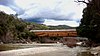
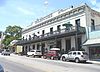
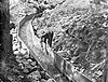
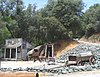
Image [ 1] Landmark name Location City or town Summary Alpha Hydraulic Diggings 628 Alpha Hydraulic Diggings Omega Rest Area 39°20′08″N 120°47′14″W / 39.335454°N 120.787162°W / 39.335454; -120.787162 (Alpha Hydraulic Diggings ) Washington Bridgeport Covered Bridge 390 Bridgeport Covered Bridge Pleasant Valley Rd. and Yuba River 39°17′34″N 121°11′42″W / 39.292739°N 121.194906°W / 39.292739; -121.194906 (Bridgeport Covered Bridge ) French Corral Discovery of Gold at Gold Hill 297 Discovery of Gold at Gold Hill Jenkins St. & Hocking Ave. 39°12′47″N 121°04′09″W / 39.213056°N 121.069167°W / 39.213056; -121.069167 (Discovery of Gold at Gold Hill ) Grass Valley Donner Monument 134 Donner Monument Donner Memorial State Park 39°19′12″N 120°14′30″W / 39.32°N 120.241667°W / 39.32; -120.241667 (Donner Monument ) Truckee Empire Mine 298 Empire Mine Empire Mine State Historic Park 39°12′13″N 121°02′34″W / 39.203611°N 121.042778°W / 39.203611; -121.042778 (Empire Mine ) Grass Valley First Manufacturing Site of the Pelton Wheel 1012 First Manufacturing Site of the Pelton Wheel 325 Spring St. 39°15′44″N 121°01′11″W / 39.262167°N 121.019733°W / 39.262167; -121.019733 (First Manufacturing Site of the Pelton Wheel ) Nevada City First Transcontinental Railroad-Truckee 780 First Transcontinental Railroad-Truckee 70 Donner Pass Rd. 39°19′39″N 120°11′07″W / 39.327467°N 120.185383°W / 39.327467; -120.185383 (First Transcontinental Railroad-Truckee ) Truckee Holbrooke Hotel 914 Holbrooke Hotel 212 W. Main St. 39°13′08″N 121°03′48″W / 39.218883°N 121.063333°W / 39.218883; -121.063333 (Holbrooke Hotel ) Grass Valley Home of Lola Montez 292 Home of Lola Montez 248 Mill St. 39°13′00″N 121°03′50″W / 39.21657°N 121.06401°W / 39.21657; -121.06401 (Home of Lola Montez ) Grass Valley Home of Lotta Crabtree 293 Home of Lotta Crabtree 238 Mill St. 39°13′00″N 121°03′50″W / 39.21665°N 121.06392°W / 39.21665; -121.06392 (Home of Lotta Crabtree ) Grass Valley Mount Saint Mary's Convent and Academy 855 Mount Saint Mary's Convent and Academy Church St. between Chapel and Dalton Sts. 39°12′53″N 121°04′03″W / 39.214722°N 121.0675°W / 39.214722; -121.0675 (Mount Saint Mary's Convent and Academy ) Grass Valley National Exchange Hotel 899 National Exchange Hotel 211 Broad St. 39°15′45″N 121°01′01″W / 39.2625°N 121.016944°W / 39.2625; -121.016944 (National Exchange Hotel ) Nevada City Nevada Theatre 863 Nevada Theatre 401 Broad Street 39°15′47″N 121°01′09″W / 39.263056°N 121.019167°W / 39.263056; -121.019167 (Nevada Theatre ) Nevada City North Bloomfield Mining and Gravel Company 852 North Bloomfield Mining and Gravel Company Malakoff Diggins State Historic Park 39°22′07″N 120°54′49″W / 39.368611°N 120.913553°W / 39.368611; -120.913553 (North Bloomfield Mining and Gravel Company ) North Star Mine Powerhouse 843 North Star Mine Powerhouse Mining and Pelton Wheel Museum 39°12′31″N 121°04′11″W / 39.208611°N 121.069722°W / 39.208611; -121.069722 (North Star Mine Powerhouse ) Grass Valley Omega Hydraulic Diggings 629 Omega Hydraulic Diggings Omega Rest Area 39°20′00″N 120°44′54″W / 39.333333°N 120.748333°W / 39.333333; -120.748333 (Omega Hydraulic Diggings ) Washington Overland Emigrant Trail 799 Overland Emigrant Trail Wolf Creek Bridge 39°03′43″N 121°05′19″W / 39.061883°N 121.08855°W / 39.061883; -121.08855 (Overland Emigrant Trail ) Grass Valley Rough and Ready 294 Rough and Ready State Hwy 20 and Mountain Rose Rd. 39°13′49″N 121°08′06″W / 39.230278°N 121.135°W / 39.230278; -121.135 (Rough and Ready ) Rough and Ready South Yuba Canal Office 832 South Yuba Canal Office 134 Main St. 39°15′47″N 121°01′01″W / 39.262933°N 121.01685°W / 39.262933; -121.01685 (South Yuba Canal Office ) Nevada City World's first long-distance telephone line 247 World's first long-distance telephone line Pleasant Valley Rd. 39°18′24″N 121°09′46″W / 39.30665°N 121.1628°W / 39.30665; -121.1628 (World's first long-distance telephone line ) French Corral