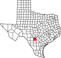
Medina County | |
---|---|
Coordinates: 29°21′N99°07′W / 29.35°N 99.11°W | |
Country | United States |
State | Texas |
Founded | 1848 |
Named for | Medina River |
Seat | Hondo |
Largest city | Hondo |
Area | |
• Total | 1,335 sq mi (3,460 km2) |
• Land | 1,325 sq mi (3,430 km2) |
• Water | 9.2 sq mi (24 km2) 0.7% |
Population (2020) | |
• Total | 50,748 |
• Density | 38/sq mi (15/km2) |
Time zone | UTC−6 (Central) |
• Summer (DST) | UTC−5 (CDT) |
Congressional district | 23rd |
Website | www |
Medina County is a county located in the U.S. state of Texas. As of the 2020 census, its population was 50,748. [1] Its county seat is Hondo. [2] The county is named for the Medina River. The extreme northern part of the county lies within the Edwards Plateau, which elevates into the Texas Hill Country. The Medina Dam, the fourth largest in the nation when completed in 1913, is listed on the National Register of Historic Places. [3] The irrigation project, creating Medina Lake, was built by 1500 skilled workers who worked in shifts operating 24 hours a day to complete the dam in two years. Medina County is part of the San Antonio, TX Metropolitan Statistical Area.
The county is named after the Medina River, which was named in 1689 after the Spanish cartographer Pedro de Medina by the Spanish explorer Alonso de Leon, the first European to encounter the river. [4] Because Pedro de Medina derived his surname from the Andalusian city of Medina-Sidonia, the name Medina comes from the Arabic for city.
The Texas Legislature formed Medina county on February 12, 1848, and enlarged it on February 1, 1850, using land taken from Bexar County. Castroville was the county seat, and the county erected the first permanent courthouse there in 1854. The county seat moved to Hondo in 1892, and a new courthouse was completed there in 1893. [5]
The county was home to tribes such as the Lipan Apache, Coahuiltecan, and Tonkawa.
The county was subject to frequent Comanche and Kiowa raids during the 1860s and 1870s. On a June 11, 1873 raid, Comanches attacked four settlers near Hondo. These raids were feared by the local residents, however by 1875, the raiding had stopped. However, although the Comanche were gone, there were still other tribes raiding the county very frequently.
The last Indian raid of the county happened on April 22, 1877, when 19 year old Joe Wilton was killed by Indians near Devine, Texas.
According to the U.S. Census Bureau, the county has a total area of 1,335 square miles (3,460 km2), of which 1,325 square miles (3,430 km2) is land and 9.2 square miles (24 km2) (0.7%) is water. [6]
Census | Pop. | Note | %± |
---|---|---|---|
1850 | 909 | — | |
1860 | 1,838 | 102.2% | |
1870 | 2,078 | 13.1% | |
1880 | 4,492 | 116.2% | |
1890 | 5,730 | 27.6% | |
1900 | 7,783 | 35.8% | |
1910 | 13,415 | 72.4% | |
1920 | 11,679 | −12.9% | |
1930 | 13,989 | 19.8% | |
1940 | 16,106 | 15.1% | |
1950 | 17,013 | 5.6% | |
1960 | 18,904 | 11.1% | |
1970 | 20,249 | 7.1% | |
1980 | 23,164 | 14.4% | |
1990 | 27,312 | 17.9% | |
2000 | 39,304 | 43.9% | |
2010 | 46,006 | 17.1% | |
2020 | 50,748 | 10.3% | |
U.S. Decennial Census [7] 1850–2010 [8] 2010 [9] 2020 [10] |
Race / Ethnicity (NH = Non-Hispanic) | Pop 2000 [11] | Pop 2010 [9] | Pop 2020 [10] | % 2000 | % 2010 | % 2020 |
---|---|---|---|---|---|---|
White alone (NH) | 19,919 | 21,408 | 22,324 | 50.68% | 46.53% | 43.99% |
Black or African American alone (NH) | 801 | 913 | 1,252 | 2.04% | 1.98% | 2.47% |
Native American or Alaska Native alone (NH) | 144 | 146 | 158 | 0.37% | 0.32% | 0.31% |
Asian alone (NH) | 117 | 272 | 215 | 0.30% | 0.59% | 0.42% |
Pacific Islander alone (NH) | 17 | 24 | 38 | 0.04% | 0.05% | 0.07% |
Other race alone (NH) | 50 | 28 | 188 | 0.13% | 0.06% | 0.37% |
Mixed race or Multiracial (NH) | 383 | 344 | 1,118 | 0.97% | 0.75% | 2.20% |
Hispanic or Latino (any race) | 17,873 | 22,871 | 25,455 | 45.47% | 49.71% | 50.16% |
Total | 39,304 | 46,006 | 50,748 | 100.00% | 100.00% | 100.00% |
As of the census [12] of 2000, there were 39,304 people, 12,880 households, and 10,136 families residing in the county. The population density was 30 people per square mile (12 people/km2). There were 14,826 housing units at an average density of 11 units per square mile (4.2/km2). The racial makeup of the county was 79.38% White, 2.20% Black or African American, 0.68% Native American, 0.33% Asian, 0.05% Pacific Islander, 14.48% from other races, and 2.88% from two or more races. 45.47% of the population were Hispanic or Latino of any race.
There were 12,880 households, out of which 39.10% had children under the age of 18 living with them, 63.20% were married couples living together, 11.10% had a female householder with no husband present, and 21.30% were non-families. 18.20% of all households were made up of individuals, and 8.20% had someone living alone who was 65 years of age or older. The average household size was 2.91 and the average family size was 3.30.
In the county, the population was spread out, with 29.00% under the age of 18, 8.40% from 18 to 24, 28.70% from 25 to 44, 21.50% from 45 to 64, and 12.40% who were 65 years of age or older. The median age was 34 years. For every 100 females, there were 105.60 males. For every 100 females age 18 and over, there were 104.90 males.
The median income for a household in the county was $36,063, and the median income for a family was $40,288. Males had a median income of $27,045 versus $21,734 for females. The per capita income for the county was $15,210. About 12.00% of families and 15.40% of the population were below the poverty line, including 19.80% of those under age 18 and 15.60% of those age 65 or over.
School districts include: [13]
The designated community college is Southwest Texas Junior College. [14]
Year | Republican | Democratic | Third party(ies) | |||
---|---|---|---|---|---|---|
No. | % | No. | % | No. | % | |
2020 | 15,642 | 69.04% | 6,773 | 29.89% | 242 | 1.07% |
2016 | 12,085 | 70.07% | 4,634 | 26.87% | 527 | 3.06% |
2012 | 11,079 | 69.03% | 4,784 | 29.81% | 186 | 1.16% |
2008 | 10,480 | 66.59% | 5,147 | 32.71% | 110 | 0.70% |
2004 | 10,389 | 70.07% | 4,322 | 29.15% | 115 | 0.78% |
2000 | 8,590 | 66.73% | 4,025 | 31.27% | 258 | 2.00% |
1996 | 5,710 | 55.03% | 3,880 | 37.39% | 787 | 7.58% |
1992 | 4,912 | 45.54% | 3,650 | 33.84% | 2,223 | 20.61% |
1988 | 5,722 | 57.05% | 4,227 | 42.15% | 80 | 0.80% |
1984 | 5,737 | 65.17% | 3,053 | 34.68% | 13 | 0.15% |
1980 | 4,742 | 60.12% | 3,034 | 38.46% | 112 | 1.42% |
1976 | 3,252 | 46.54% | 3,681 | 52.68% | 55 | 0.79% |
1972 | 4,059 | 71.85% | 1,507 | 26.68% | 83 | 1.47% |
1968 | 2,058 | 39.19% | 2,471 | 47.06% | 722 | 13.75% |
1964 | 1,583 | 31.71% | 3,408 | 68.27% | 1 | 0.02% |
1960 | 2,028 | 46.43% | 2,325 | 53.23% | 15 | 0.34% |
1956 | 2,668 | 63.51% | 1,516 | 36.09% | 17 | 0.40% |
1952 | 3,204 | 63.52% | 1,840 | 36.48% | 0 | 0.00% |
1948 | 1,492 | 42.39% | 1,875 | 53.27% | 153 | 4.35% |
1944 | 1,607 | 47.42% | 1,469 | 43.35% | 313 | 9.24% |
1940 | 1,480 | 45.83% | 1,749 | 54.17% | 0 | 0.00% |
1936 | 969 | 31.97% | 2,050 | 67.63% | 12 | 0.40% |
1932 | 515 | 16.96% | 2,516 | 82.87% | 5 | 0.16% |
1928 | 1,243 | 46.94% | 1,400 | 52.87% | 5 | 0.19% |
1924 | 816 | 35.81% | 986 | 43.26% | 477 | 20.93% |
1920 | 772 | 45.71% | 519 | 30.73% | 398 | 23.56% |
1916 | 650 | 45.11% | 758 | 52.60% | 33 | 2.29% |
1912 | 219 | 18.85% | 648 | 55.77% | 295 | 25.39% |
Yoakum County is a county located in the far western portion of the U.S. state of Texas. As of the 2020 census, the population was 7,694. Its county seat is Plains. The county was created in 1876 and later organized in 1907. It is named for Henderson King Yoakum, a Texas historian.
Swisher County is a county in the U.S. state of Texas. As of the 2020 census, its population was 6,971. Its county seat is Tulia. The county was created in 1876 and later organized in 1890. It is named for James G. Swisher, a soldier of the Texas Revolution and signer of the Texas Declaration of Independence.
Lynn County is a county in the U.S. state of Texas. As of the 2020 census, its population was 5,596. Its county seat is Tahoka. The county was created in 1876 and organized in 1903.
Live Oak County is a county in the U.S. state of Texas. It was named for its native groves of live oak. George West is its county seat. Its population was 11,335 in the 2020 census.
Frio County is a county located in the U.S. state of Texas. As of the 2020 census, its population was 18,385. The county seat is Pearsall. The county was created in 1858 and later organized in 1871. Frio is named for the Frio River, whose name is Spanish for "cold".
Bexar County is a county in the U.S. state of Texas. It is in South Texas and its county seat is San Antonio.
Bandera County is a county in the U.S. state of Texas. It is located in the Hill Country and its county seat is Bandera. Bandera county was settled by German and Polish emigrants in the mid 1800s. Many residents are descendants of those same emigrants.
Atascosa County is a county located in the U.S. state of Texas. It is in South Texas and its county seat is Jourdanton.
Cross Mountain is a census-designated place (CDP) in Bexar County, Texas, United States. The population was 3,944 at the 2020 census, an increase over the figure of 3,124 tabulated in 2010. It is part of the San Antonio Metropolitan Statistical Area.
Scenic Oaks is a census-designated place (CDP) in Bexar County, Texas, United States. It is part of the San Antonio Metropolitan Statistical Area. The population was 10,458 at the 2020 census, up from 4,957 at the 2010 census.
Windcrest is a city in Bexar County, Texas, United States. Its population was 5,865 at the 2020 census. It is part of the San Antonio metropolitan area.
Rio Hondo is a city in Cameron County, Texas, United States. The population was 2,021 at the 2010 census. It may be included as part of the Brownsville–Harlingen–Raymondville and the Matamoros–Brownsville metropolitan areas.
Comanche is a city located in Comanche County in the U.S. state of Texas. The population was 4,211 at the 2020 census. It is the county seat of Comanche County.
Castroville is a city in Medina County, Texas, United States. Its population was 2,954 at the 2020 census, up from 2,680 at the 2010 census. It is part of the San Antonio–New Braunfels, Texas Metropolitan Statistical Area. Castroville was founded by Alsatian-Texans, who came to Texas during the German emigration period of the mid-1800s. Most Alsatians who came to Castroville spoke Alsatian. The Alsatian culture and language are still kept alive by the residents of Castroville. Prior to 1893, Castroville was the first county seat of Medina County.
Devine is a city in Medina County, Texas, United States. The population was 4,324 at the 2020 census. It is part of the San Antonio Metropolitan Statistical Area.
Hondo is a city in and the county seat of Medina County, Texas, United States. According to the 2020 Census, the population was 8,289. It is part of the San Antonio Metropolitan Statistical Area.
Fair Oaks Ranch is a city in Bexar, Comal, and Kendall counties in the U.S. state of Texas. The population was 9,833 at the 2020 census, and an estimated 10,505 in 2021. It is part of the San Antonio-New Braunfels Metropolitan Statistical Area. The city was named after Ralph Fair Sr, an oilman who had a large cattle ranch on the now residential town. The Fair family decided to sell a portion of the ranch to build what is now Fair Oaks Ranch in 1975.
D'Hanis is a census-designated place in central Medina County, Texas, United States. It is part of the San Antonio—New Braunfels, Texas Metropolitan Statistical Area. The population was 785 at the 2020 census, up from 548 in 2000. It was primarily settled in the 1800s by German emigrants.
Greater San Antonio, officially designated San Antonio–New Braunfels, is an eight-county metropolitan area in the U.S. state of Texas defined by the Office of Management and Budget (OMB). The metropolitan area straddles South Texas and Central Texas and is on the southwestern corner of the Texas Triangle. The official 2020 U.S. census showed the metropolitan area's population at 2,558,143—up from a reported 1,711,103 in 2000—making it the 24th largest metropolitan area in the United States. Downtown Austin and Downtown San Antonio are approximately 80 miles (129 km) apart, and both fall along the Interstate 35 corridor. This combined metropolitan region of San Antonio–Austin has approximately 5 million people.
Runnels County is a county located in the U.S. state of Texas. As of the 2020 census, its population was 9,900. Its county seat is Ballinger. The county was created in 1858 and later organized in 1880. It is named for Hiram G. Runnels, a Texas state legislator.
Media related to Medina County, Texas at Wikimedia Commons