Afghanistan, officially the Islamic Emirate of Afghanistan, is a landlocked country located at the crossroads of Central Asia and South Asia. It is bordered by Pakistan to the east and south, Iran to the west, Turkmenistan to the northwest, Uzbekistan to the north, Tajikistan to the northeast, and China to the northeast and east. Occupying 652,864 square kilometers (252,072 sq mi) of land, the country is predominantly mountainous with plains in the north and the southwest, which are separated by the Hindu Kush mountain range. Kabul is the country's capital and largest city. According to the World Population review, as of 2023, Afghanistan's population is 43 million. The National Statistics Information Authority of Afghanistan estimated the population to be 32.9 million as of 2020.

The economy of Afghanistan is listed as the 124th largest in the world in terms of nominal gross domestic product (GDP), and 102nd largest in the world in terms of purchasing power parity (PPP). With a population of around 41 million people, Afghanistan's GDP (nominal) stands at $14.58 billion as of 2021, amounting to a GDP per capita of $363.7. Its annual exports exceed $2 billion, with agricultural, mineral and textile products accounting for 94% of total exports. The nation's total external debt is $1.4 billion as of 2022.
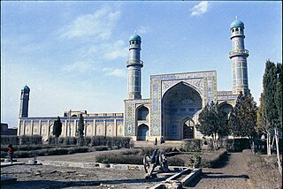
Herāt is an oasis city and the third-largest city in Afghanistan. In 2020, it had an estimated population of 574,276, and serves as the capital of Herat Province, situated south of the Paropamisus Mountains in the fertile valley of the Hari River in the western part of the country. An ancient civilization on the Silk Road between West Asia, Central Asia, and South Asia, it serves as a regional hub in the country's west.

Transport in Afghanistan is done mostly by road, rail and air. Much of the nation's road network was built in the mid-20th century but left to ruin during the last two decades of that century due to war and political turmoil. Officials of the current Islamic Emirate have continued to improve the national highways, roads, and bridges. In 2008, there were about 700,000 vehicles registered in Kabul. At least 1,314 traffic collisions were reported in 2022.
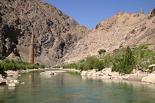
The Hari River or Herat River or Tejen River or Harirud is a river flowing 1,100 kilometres (680 mi) from the mountains of central Afghanistan to Turkmenistan, where it forms the Tejen oasis and disappears in the Karakum Desert. In its lower course, the river forms a northern part of the border between Afghanistan and Iran, and a southeastern part of the border between Turkmenistan and Iran.

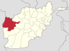
Herat is one of the thirty-four provinces of Afghanistan, located in the western part of the country. Together with Badghis, Farah, and Ghor provinces, it makes up the north-western region of Afghanistan. Its primary city and administrative capital is Herat City. The province of Herat is divided into about 17 districts and contains over 2,000 villages. It has a population of about 3,780,000, making it the second most populated province in Afghanistan behind Kabul Province. The population is multi-ethnic but largely Persian-speaking. Herat dates back to the Avestan times and was traditionally known for its wine. The city has a number of historic sites, including the Herat Citadel and the Musalla Complex. During the Middle Ages Herat became one of the important cities of Khorasan, as it was known as the Pearl of Khorasan.

Helmand, also known as Hillmand, in ancient times, as Hermand and Hethumand, is one of the 34 provinces of Afghanistan, in the south of the country. It is the largest province by area, covering 58,584 square kilometres (20,000 sq mi) area. The province contains 18 districts, encompassing over 1,000 villages, and roughly 1,446,230 settled people. Lashkargah serves as the provincial capital. Helmand was part of the Greater Kandahar region until made into a separate province by the Afghan government in the 20th century.
Nimruz or Nimroz is one of the 34 provinces of Afghanistan, located in the southwestern part of the country. It lies to the east of the Sistan and Baluchestan Province of Iran and north of Balochistan, Pakistan, also bordering the Afghan provinces of Farah and Helmand. It has a population of about 186,963 people. The province is divided into five districts, encompassing about 649 villages.

South Khorasan province is one of the 31 provinces of Iran, located in the eastern part of the country. Its capital is the city of Birjand. In 2014, the province was placed in Region 5.
The following lists events that happened during 2000 in Afghanistan.
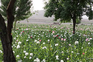
Afghanistan has long had a history of opium poppy cultivation and harvest. As of 2021, Afghanistan's harvest produces more than 90% of illicit heroin globally, and more than 95% of the European supply. More land is used for opium in Afghanistan than is used for coca cultivation in Latin America. The country has been the world's leading illicit drug producer since 2001. In 2007, 93% of the non-pharmaceutical-grade opiates on the world market originated in Afghanistan. By 2019 Afghanistan still produced about 84% of the world market. This amounts to an export value of about US$4 billion, with a quarter being earned by opium farmers and the rest going to district officials, insurgents, warlords, and drug traffickers. In the seven years (1994–2000) prior to a Taliban opium ban, the Afghan farmers' share of gross income from opium was divided among 200,000 families.
Adraskan is a district in the central part of Herat Province in Afghanistan. It is bordered to the west by Iran, to the north by Ghoryan District, Zinda Jan District, Guzara District, Pashtun Zarghun District and Obe District, to the east by Farsi District and to the south by Shindand District.
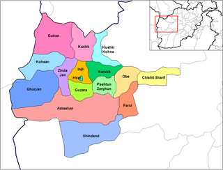
Ghurian is a city and the administrative center of Ghurian District in Herat Province, Afghanistan. It is 790 m high with a population of more than 54,000 people. It is situated south of the Hari River along the Mashhad-Herat highway at 34.34°N 61.47°E. There is a local TV station and a health center. Ghurian is close to the old city of Pushang. In 2020 Ghurian was connected by rail to Khaf in Iran.
Gulran District is situated in northwestern part of Herat province, Afghanistan and borders Iran to the west, Turkmenistan to the north, Kushk District to the east, and Zinda Jan District and Kohsan District to the south. The population is 91,500 (2012). The district center is the village of Gulran. There are no mountains in the district.
Kohsan is a district of Herat province in northwestern Afghanistan. It borders the nation of Iran to the west, Gulran District to the north, and Ghurian District to the south and east. The population of Kosan District is 52,900, which includes the following ethnic groups: 59.4% Pashtun, 35.3% Tajik, 5.1% Balouch, and 0.2% Turkmen.
The Zinda Jan District is located in the central part of Herat Province in Afghanistan. It borders Gulran and Kushk districts to the north, Injil and Guzara districts to the east, Adraskan District to the south and Ghoryan and Kohsan districts to the west. The population is 55,500. The district center is the town of Zendeh Jan, situated in the valley of the Hari River.
This article deals with activities of the U.S. Central Intelligence Agency related to transnational crime, including the illicit drug trade.

Islām Qala is a border town in the western Herat province of Afghanistan, near the Afghanistan–Iran border. It is the official port of entry by land from neighboring Taybad in Iran. The Dowqarun-Islam Qala border crossing is located about 10 km (6.2 mi) northwest of the town.
Mohammad Hashim Aslami is an Afghani agriculturist who was instrumental in growing the country's saffron crop from a $100 grant in 1998 to a $25 million export industry in 2019, despite the wars that engulfed his country during that time. The Afghani president has placed a ban on the importation of the spice from Iran due to the quality of the nations export crop initiating a 'soft' war between the two nations.
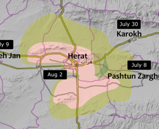
The Fall of Herat was a battle and subsequent capture of Herat by Taliban fighters. The attack on the city started around 28 July 2021, and ended in Taliban victory by 13 August of the same year. Several of the surrounding districts fell to the Taliban from June to mid-July, leaving only the city and two other districts in government hands by 10 July. The border crossings in Herat Province were captured by the Taliban on 9 July, raising prices of goods inside the city. Ismail Khan, former governor and warlord, led a public uprising force to assist the Afghan National Security Forces in defending the city.