Tenth (country subdivision)

Last updated
Tenth
Category County subdivision
Location West New Jersey
Found in Counties
Created Various, see text
Abolished Various, see text
Possible status Defunct
Areas Up to 64,000 acres
Government Constables
Road Overseers
Surveyors of the Highways
Assessors
Tax Collectors
Subdivisions Precincts
Townships
Constableries

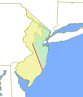
A tenth was a geographic division used in the former American Province of West Jersey, to divide a larger region into smaller administrative divisions. Despite seemingly related names, tenths are not directly related to hundreds, other than both being administrative divisions.

Contents

History

West Jersey was first divided into ten shares when Edward Byllynge and John Fenwick sold parts of their shares to others in order to defray debts. Byllynge, William Penn, Gawen Lawrie and Nicholas Lucas retained nine tenths of the province, with Fenwick retaining one tenth. [1] Fenwick's tenth would eventually evolve into Salem County.

Edward Byllynge was a British colonial administrator and governor of West New Jersey from 1680 to 1687, until his death in England. Byllynge owned a large section of land in New Jersey with the Quakers.

John Fenwick (1618–1683) was the leader of a group of Quakers who emigrated in 1675 from England to Salem, New Jersey where they established Fenwick's Colony, the first English settlement in West Jersey.

William Penn English real estate entrepreneur, philosopher, early Quaker and founder of the Province of Pennsylvania

William Penn was the son of Sir William Penn, and was an English nobleman, writer, early Quaker, and founder of the English North American colony the Province of Pennsylvania. He was an early advocate of democracy and religious freedom, notable for his good relations and successful treaties with the Lenape Native Americans. Under his direction, the city of Philadelphia was planned and developed.

Tenths were formally established by the Lords Proprietors of West New Jersey under "The Concessions and Agreements of the Proprietors, Freeholders and Inhabitants of the Province of West New Jersey, in America", approved March 3, 1676/77, which provided for "dividing all the lands of the said Province, as be already taken up, or by themselves shall be taken up and contracted for with the natives; and the said lands so taken up and contracted for, to divide into one hundred parts, as occasion shall require; that is to say, for every quantity of land that they shall from time to time lay out to be planted and settled upon, they shall first for expedition divide the same into ten equal parts or shares". [2]

In February 1681 "The Methods of the Commissioners for settling and regulation of Lands" directed that each tenth was to contain 64,000 acres, and to "have their proportion of front to the river Delaware". [3] Only five of the tenths were actually organized.

Delaware River major river on the East coast of the United States of America

The Delaware River is a major river on the Atlantic coast of the United States. It drains an area of 14,119 square miles (36,570 km2) in five U.S. states: Delaware, Maryland, New Jersey, New York, Pennsylvania. Rising in two branches in New York state's Catskill Mountains, the river flows 419 miles (674 km) into Delaware Bay where its waters enter the Atlantic Ocean near Cape May in New Jersey and Cape Henlopen in Delaware. Not including Delaware Bay, the river's length including its two branches is 388 miles (624 km). The Delaware River is one of nineteen "Great Waters" recognized by the America's Great Waters Coalition.

Government

County Jurisdiction

Courts were established in 1681 at Salem and Burlington; the former to have jurisdiction over the Salem Tenth and the latter over the remaining nine tenths. A court was established at Gloucester in 1686 and had jurisdiction within the Third and Fourth Tenths. [4] Three counties would appear to have been formalized before 1692 when the fourth, Cape May, was incorporated. [5]

Cape May County, New Jersey county in New Jersey, United States

Cape May County is the southernmost county in the U.S. state of New Jersey. Much of the county is located on the Cape May Peninsula, bounded by the Delaware Bay to the west, and the Atlantic Ocean to the south and east. Adjacent to the Atlantic coastline are five barrier islands that have been built up as seaside resorts. A consistently popular summer destination with 30 miles (48 km) of beaches, Cape May County attracts vacationers from New Jersey and surrounding states, with the summer population exceeding 750,000. Tourism generates annual revenues of about $6 billion as of 2015, making it the county's single largest industry, with leisure and hospitality being Cape May's largest employment category. Its county seat is the Cape May Court House section of Middle Township.

Legislative Constituencies

The Concessions and Agreements provided for the election of a General Free Assembly; each tenth was a multi-member constituency electing a potential of ten members, although in practice this was limited to the settled and organized tenths. This was further codified by legislation approved in May 1682. [6] This apportionment would remain, in modified form, after the establishment of counties and up until the surrender of the proprietary charter in 1702.

Local Government

Tenths also functioned as units of local government. Chapter 44 of the Concessions and Agreements authorized the Assembly, " to sub-divide the said province into hundreds, proprieties, or such other divisions and distinctions, as they shall think fit". As early as 1682, constables were designated for the First, Second and Third Tenths. [7] The following year, road maintenance was assigned to the tenths; the legislation directing "that the courts shall and may appoint such and so many overseers within their respective liberties, to repair and amend, and maintain the said highways, as they shall judge needful". [8] The authority to lay out highways was enumerated in 1684, with commissioners appointed for the First, Second, Third and Salem tenths. [9] Legislation enacted at the same session required the tenths to raise taxes for making and repairing bridges and highways, as well as for a number of expenses of the Province. For this purpose, each tenth was to nominate six assessors and two tax collectors. [10]

Abandonment

The system of tenths was gradually abandoned in favor of townships.

Salem Tenth, which had from the beginning taken a more independent approach than the others, was subdivided into five townships or precincts as early as the mid-1670s, namely, East Fenwick, Elsinburgh, Monmouth, West Fenwick and the town of Salem. [11]

Burlington County, encompassing the First and Second Tenths, established eight "constablries" in 1688, being Chester or Cropwell, Chesterfield, Eversham, Mansfield, Northampton, Nottingham, Springfield, and Wellingborrow. The Town of Burlington had been authorized in 1677 under the Concessions and Agreements. [12]

Gloucester County, which encompassed the Third and Fourth Tenths, in 1695 established the townships of Deptford, Gloucester, Greenwich, Newton and Waterford. [13] These joined Gloucestertown, which had been formed by the Burlington Court in 1685. [14]

List of Tenths in West New Jersey

See also

Related Research Articles

West Jersey English possession in North America between 1674 and 1702

West Jersey and East Jersey were two distinct parts of the Province of New Jersey. The political division existed for 28 years, between 1674 and 1702. Determination of an exact location for a border between West Jersey and East Jersey was often a matter of dispute.

New Jersey Legislature the legislature of the U.S. state of New Jersey

The New Jersey Legislature is the legislative branch of the government of the U.S. state of New Jersey. In its current form, as defined by the New Jersey Constitution of 1947, the Legislature consists of two houses: the General Assembly and the Senate. The Legislature meets in the New Jersey State House, in the state capital of Trenton. Democrats currently hold super majorities in both chambers of the legislature.

Keith line

The Keith line was a line drawn through the Province of New Jersey, dividing it into the Province of West Jersey and the Province of East Jersey. The line was created by Surveyor-General George Keith in 1686, when he ran the first survey to mark out the border between West Jersey and East Jersey. The Keith line was intended to clarify disputes resulting from the 1676 Quintipartite Deed, which created the two territories.

This article is for the now-defunct town in Hudson County, NJ. For the current towns of the same name in Hunterdon County and Union County, seeUnion Township, Hunterdon County, New Jersey and Union Township, Union County, New Jersey.

Thomas Rudyard was a deputy governor of East Jersey.

Gawen Lawrie was a deputy governor of the American province of East Jersey from 1683 to 1686.

Nottingham Township was a township that existed for almost 168 years in New Jersey, from 1688 until it was dissolved in 1856.

Gloucestertown was a township that existed within the territory of the current Camden County, New Jersey, United States, from 1685 to 1831.

Alloways Creek Township is a defunct municipality in Salem County, New Jersey, United States.

Randolph Township is a former township in Burlington County, New Jersey, United States, that lasted for 23 years after splitting off from and being reannexed by Washington Township, Burlington County, New Jersey.

Centreville Township was a township that existed from 1822 to 1829 in Salem County, New Jersey, United States.

Penn's Neck Township was a township that existed in Salem County, New Jersey, United States, from 1701 until 1721.

William Bates, or William Bate, and other Quakers emigrated from Ireland to Gloucester County, New Jersey where in 1682 they established Newton Colony, the third English settlement in West Jersey. William Bates was the first English-speaking settler of present-day Oaklyn, New Jersey.

The New Jersey Provincial Council was the upper house of the New Jersey Legislature under colonial rule until it was replaced by the New Jersey Legislative Council under the New Jersey Constitution of 1776.

John Skene was the third deputy governor of West Jersey, part of the American Province of New Jersey, serving from October 1684 to April 1692.

The Lawrence Line was a boundary line or partition line drawn through the Province of New Jersey during the colonial period, dividing it into the Province of West Jersey and the Province of East Jersey. The line was created by surveyor John Lawrence in 1743, and sought to offer final resolution to the division between the two proprietary colonies set out on the Quintipartite Deed (1676) which divided New Jersey by a straight line from "the Northernmost Branch of said Bay or River of De la Ware which is in forty-one Degrees and forty minutes of latitude…unto the most southwardly poynt of the East syde of Little Egge Harbour." Several previous surveys, including the Keith Line (1686), the Coxe–Barclay Line (1688), the Thornton Line (1696) were disputed and drawn too far west. Lawrence was commissioned in 1743 to resolve the long-standing disputes.

East New Jersey Provincial Council

The East New Jersey Provincial Council or Governor's Council was the upper house of the East New Jersey Legislature under proprietary rule until the surrender of the right of government to The Crown, and Queen Anne's acceptance.

Eliakim Wardell was an early settler of Monmouth County, New Jersey, and served as that county's first sheriff.

References

  1. "The Story of New Jersey's Civil Boundaries: 1606–1968", John P. Snyder, Bureau of Geology and Topography; Trenton, New Jersey; 1969. p. 9.
  2. 1 2 "The Story of New Jersey's Civil Boundaries: 1606–1968", John P. Snyder, Bureau of Geology and Topography; Trenton, New Jersey; 1969. p. 12.
  3. "The Grants, Concessions and Original Constitutions of the Province of New Jersey", Aaron Leaming and Jacob Spicer; W. Bradford, Philadelphia, Pennsylvania, 1758. p. 437
  4. "The Story of New Jersey's Civil Boundaries: 1606–1968", John P. Snyder, Bureau of Geology and Topography; Trenton, New Jersey; 1969. pp. 12.
  5. "The Grants, Concessions and Original Constitutions of the Province of New Jersey", Aaron Leaming and Jacob Spicer; W. Bradford, Philadelphia, Pennsylvania, 1758. p. 507
  6. "The Grants, Concessions and Original Constitutions of the Province of New Jersey", Aaron Leaming and Jacob Spicer; W. Bradford, Philadelphia, Pennsylvania, 1758. p. 443
  7. "The Grants, Concessions and Original Constitutions of the Province of New Jersey", Aaron Leaming and Jacob Spicer; W. Bradford, Philadelphia, Pennsylvania, 1758. p. 444
  8. "The Grants, Concessions and Original Constitutions of the Province of New Jersey", Aaron Leaming and Jacob Spicer; W. Bradford, Philadelphia, Pennsylvania, 1758. p. 459
  9. "The Grants, Concessions and Original Constitutions of the Province of New Jersey", Aaron Leaming and Jacob Spicer; W. Bradford, Philadelphia, Pennsylvania, 1758. p. 492-493
  10. "The Grants, Concessions and Original Constitutions of the Province of New Jersey", Aaron Leaming and Jacob Spicer; W. Bradford, Philadelphia, Pennsylvania, 1758. p. 493-495
  11. "The Story of New Jersey's Civil Boundaries: 1606–1968", John P. Snyder, Bureau of Geology and Topography; Trenton, New Jersey; 1969. pp. 215-219.
  12. "The Story of New Jersey's Civil Boundaries: 1606–1968", John P. Snyder, Bureau of Geology and Topography; Trenton, New Jersey; 1969. p. 50.
  13. "The Story of New Jersey's Civil Boundaries: 1606–1968", John P. Snyder, Bureau of Geology and Topography; Trenton, New Jersey; 1969. p. 55.
  14. "The Story of New Jersey's Civil Boundaries: 1606–1968", John P. Snyder, Bureau of Geology and Topography; Trenton, New Jersey; 1969. p. 54.
  15. "The Grants, Concessions and Original Constitutions of the Province of New Jersey", Aaron Leaming and Jacob Spicer; W. Bradford, Philadelphia, Pennsylvania, 1758. p. 504