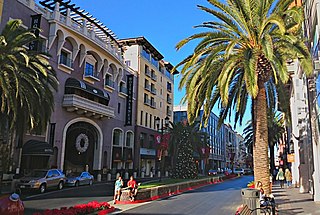
San Jose, officially the City of San José, is the largest city in Northern California by both population and area. With a 2022 population of 971,233, it is the most populous city in both the Bay Area and the San Jose–San Francisco–Oakland Combined Statistical Area—which in 2022 had a population of 7.5 million and 9.0 million respectively—the third-most populous city in California after Los Angeles and San Diego, and the 13th-most populous in the United States. Located in the center of the Santa Clara Valley on the southern shore of San Francisco Bay, San Jose covers an area of 179.97 sq mi (466.1 km2). San Jose is the county seat of Santa Clara County and the main component of the San Jose–Sunnyvale–Santa Clara Metropolitan Statistical Area, with an estimated population of around two million residents in 2018.
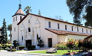
Santa Clara is a city in the county of the same name. The city's population was 127,647 at the 2020 census, making it the eighth-most populous city in the Bay Area. Located in the southern Bay Area, the city was founded by the Spanish in 1777 with the establishment of Mission Santa Clara de Asís under the leadership of Junípero Serra.

Alviso is a district of San Jose, California, located in North San Jose on the southern shores of San Francisco Bay. Originally an independent town, founded in 1852, today Alviso is San Jose's only waterfront district, primarily residential in nature, with several Silicon Valley tech companies and recreation-oriented businesses. Alviso is named after 19th-century Californio ranchero Ignacio Alviso, who owned the area as part of his Rancho Rincón de Los Esteros.
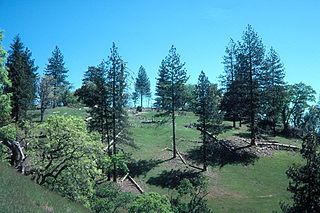
Henry W. Coe State Park is a state park of California, United States, preserving a vast tract of the Diablo Range. The park is located closest to the city of Morgan Hill, and is located in both Santa Clara and Stanislaus counties. The park contains over 87,000 acres (35,000 ha), making it the largest state park in northern California, and the second-largest in the state. Managed within its boundaries is a designated wilderness area of about 22,000 acres (8,900 ha). This is officially known as the Henry W. Coe State Wilderness, but locally as the Orestimba Wilderness. The 89,164-acre (36,083 ha) park was established in 1959.

The Diablo Range is a mountain range in the California Coast Ranges subdivision of the Pacific Coast Ranges in northern California, United States. It stretches from the eastern San Francisco Bay Area at its northern end to the Salinas Valley area at its southern end.

Gilroy Yamato Hot Springs, a California Historical Landmark and on the list of National Register of Historic Places, is a property near Gilroy, California famed for its mineral hot springs and historic development by early settlers and Japanese immigrants. The earliest extant Italianate–Victorian style structures date from the 1870s, and the earliest bathhouse dates from 1890. Other early structures are a Buddhist shrine from 1939 and a Japanese garden teahouse from that same year. The property is also listed on the National Register of Historic Places. The hot spring's temperature ranges from 99° to 111 °F. These springs are the site of occurrence of certain extremophile micro-organisms, that are capable of surviving in extremely hot environments.

Santa Clara Transit Center is a railway station in downtown Santa Clara, California. It is served by Caltrain, Amtrak Capitol Corridor, and Altamont Corridor Express (ACE) trains. It is the planned terminus for the Silicon Valley BART extension into Santa Clara County on the future Green and Orange Lines. The former station building, constructed in 1863 by the San Francisco and San Jose Railroad, is used by the Edward Peterman Museum of Railroad History.

This is intended to be a complete list of the properties and districts on the National Register of Historic Places in Santa Clara County, California, United States. Latitude and longitude coordinates are provided for many National Register properties and districts; these locations may be seen together in an online map.

Santa Clara County, officially the County of Santa Clara, is the sixth-most populous county in the U.S. state of California, with a population of 1,936,259 as of the 2020 census. Santa Clara County and neighboring San Benito County form the San Jose–Sunnyvale–Santa Clara metropolitan statistical area, which is part of the larger San Jose–San Francisco–Oakland combined statistical area. Santa Clara is the most populous county in the San Francisco Bay Area and in Northern California.
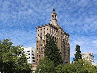
The Bank of Italy Building is a 14-story, 77.72 m (255.0 ft) Renaissance Revival high-rise built in 1925 in downtown San Jose, California. This building became the second home to the first branch of the Bank of Italy, founded in San Francisco in 1904, which later became the Bank of America. The first location of the Bank of Italy in San Jose, was on the corner of Santa Clara St. and Lightson Alley, near the intersection with Market Street. Restaurants and other businesses occupy the original building, which has been heavily remodeled. A reconstruction of the original building is at History Park in San Jose.

Pacheco Creek is a 28 miles (45 km) west by southwest flowing stream which heads in the Diablo Range in southeastern Santa Clara County and flows to San Felipe Lake, the beginning of the Pajaro River mainstem, in San Benito County, California.

The California Powder Works Bridge is a historic covered bridge in Santa Cruz, California. It is a Smith truss bridge, built across the San Lorenzo River in 1872 by the California Powder Works, an explosives manufacturer whose factory complex stood on the river banks. The bridge was designated a National Historic Landmark in 2015 as one of the best-preserved national examples of the Smith truss. It is owned and maintained by the Paradise Park Masonic Club, and is open to pedestrian and vehicular traffic, with a posted weight limit of 5 tons.
County Line Road is an unimproved road between the San Antonio Valley and Fifield Ranch that closely follows the east–west divide of the Diablo Range and the County boundary of Santa Clara County, and Stanislaus County, California. This road followed the route called La Vereda del Monte, used by Californio mesteñeros and the gang of Joaquin Murrieta and other bandits and horse-thieves, and sites of three of their camps along the route are found along it. Two sites are now state park campgrounds, the last is at ranch dating back to the 1860s.

The Moir Building, was formerly the Straford Hotel, and then in the 1930s named the St. James Hotel. It is a historic building located in downtown San Jose, California, next to the St. James Park. It was built in 1893–1894 and designed by W.D. Van Siclen. The building was placed on the National Register of Historic Places on October 29, 1982. It is one of the last remaining examples of late 19th-century Queen Anne and Romanesque Revival architecture in San Jose.

The Miller Red Barn is a historic wooden hay barn constructed in 1891, in Gilroy, California, using pole construction techniques. It was erected on land belonging to Henry Miller, a prominent California cattle baron of that era. The barn is most known for its connection to agriculture production in Santa Clara County, and its role within the agricultural estate of Henry Miller, who was a partner in the cattle-raising and meat-packing enterprise of Miller & Lux in San Francisco. The Miller Red Barn was placed on the National Register of Historic Places on September 26, 2016.

Welch-Hurst, also known as the Judge J.R. Welch's Ranch, is a historic gentleman's working ranch and family retreat in Saratoga, California. This ranch represents an early example of American Craftsman-style architectural, built for Judge James R. Welch. The Welch-Hurst ranch was placed on the National Register of Historic Places on September 18, 1978.
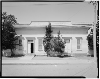
The Santa Clara Verein was built as a cultural and social center for Santa Clara's German community, used by them from its founding in 1868 until 1899, prior to World War I. The site of Santa Clara Verein was listed on the National Register of Historic Places on February 28, 1985.

Miller-Melone Ranch is a historic American Craftsman ranch-style homestead, located in Saratoga, California. The ranch house was designed and built by architect Frank Delos Wolfe in 1911 for Charles Miller and his wife Lillian Fern Melone. It is the last remaining prune ranch home in the Sarartoga area. The Miller-Melone Ranch was listed on the National Register of Historic Places on April 1, 1993.
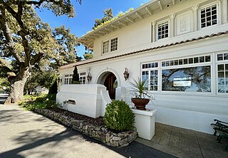
The Rhoades Ranch is a historic ranch, located near Morgan Hill, California. The 12 acres (4.9 ha) ranch is linked to Harold E. Thomas, an important figure in California's strawberry industry, and encompasses the Rhoades House, a Spanish Colonial Revival architecture residence built in 1917-1920, for William G. Rhoades and designed by architects Howard W. Higbie and Andrew P. Hill Jr. The Rhoades Ranch was officially recognized and listed on the National Register of Historic Places on April 17, 2013.

The Fairglen Additions is an example of Mid-century modern-style tract housing located in San Jose, California, US. Comprising 218 single-family houses within the Willow Glen neighborhood of San Jose, this district was built between 1959 and 1961. The additions were developed by real estate developer Joseph Eichler and designed by architectural firms Anshen & Allen, Jones Emmons & Associates, and Claude Oakland Architect & Associates. Thirteen distinct home plans were executed on approximately 6,000 square feet (560 m2) lots. These residences feature open floor plans that accentuate privacy and the seamless transition between indoor and outdoor living, characteristic of Eichler homes and subdivisions. The Fairglen Additions was officially recognized and listed on the National Register of Historic Places on June 6, 2019.


