Related Research Articles

Rock Island is a city in and the county seat of Rock Island County, Illinois, United States. The original Rock Island, from which the city name is derived, is now called Arsenal Island. The population was 39,018 at the 2010 census. Located on the Mississippi River, it is one of the Quad Cities, along with neighboring Moline, East Moline, and the Iowa cities of Davenport and Bettendorf. The Quad Cities has a population of about 380,000. The city is home to Rock Island Arsenal, the largest government-owned weapons manufacturing arsenal in the US, which employs 6,000 people.
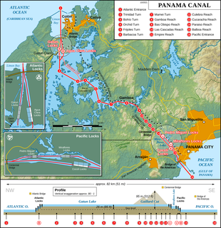
Barro Colorado Island (BCI) is located in the man-made Gatun Lake in the middle of the Panama Canal. The island was formed when the waters of the Chagres River were dammed to form the lake in 1913. When the waters rose, they covered a significant part of the existing tropical forest, but certain hilltops remained as islands in the middle of the lake. It has an area of 15.6 km2 (6.0 sq mi).
Santa Cruz Island is located off the southwestern coast of California, United States. It is the largest island in California, and largest of the eight islands in the Channel Islands archipelago. Forming part of the northern group of the Channel Islands, Santa Cruz is 22 miles (35 km) long and 2 to 6 miles wide with an area of 61,764.6 acres (249.952 km2).
The Poor Knights Islands are a group of islands off the east coast of the Northland Region of the North Island of New Zealand. They lie 50 kilometres (31 mi) to the northeast of Whangarei, and 22 kilometres (14 mi) offshore halfway between Bream Head and Cape Brett. Uninhabited since the 1820s, they are a nature reserve and popular underwater diving spot, with boat tours typically departing from Tutukaka. The Poor Knights Islands Marine Reserve surrounds the island.

Fidra is an uninhabited island in the Firth of Forth, 4 km (2.5 mi) north-west of North Berwick, on the east coast of Scotland. The island is an RSPB Scotland nature reserve.
Langstone Harbour is a 2,085.4-hectare (5,153-acre) biological Site of Special Scientific Interest in Hampshire. It is an inlet of the English Channel in Hampshire, sandwiched between Portsea Island to the south and west, Hayling Island to the south and east, and Langstone to the north. It is part of Chichester and Langstone Harbours Ramsar site, Special Protection Area and Nature Conservation Review site, Grade I. Parts of it are in Solent Maritime and Solent and Isle of Wight Lagoons Special Areas of Conservation. Three areas are Local Nature Reserves, Farlington Marshes West Hayling and The Kench, Hayling Island. Two areas are nature reserves managed by the Hampshire and Isle of Wight Wildlife Trust, Farlington Marshes and Southmoor Nature Reserve
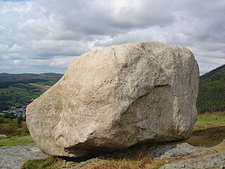
Cloughmore or Cloghmore, known locally as "The Big Stone", is a huge granite boulder perched on a mountainside almost 1,000 feet (300 m) above the village of Rostrevor, County Down, Northern Ireland. It sits on the slopes of Slieve Martin, overlooking Rostrevor Forest, Carlingford Lough and the Cooley Peninsula. It is popular destination for visitors, and is part of a National Nature Reserve and Area of Special Scientific Interest.
Gil Island is an island on the North Coast of British Columbia, Canada, located on the west side of Whale Channel in the entrance to Douglas Channel, one of the main coastal inlets, on the route of the Inside Passage between Pitt Island and Princess Royal Island. It is 26 km long, with a width ranging from 6 to 13 km, and an area of 231 km². The only named summit on the mountainous island is Mount Gil, which faces the opening of Douglas Channel.
Seymour Narrows is a 5-kilometre (3.1 mi) section of the Discovery Passage in British Columbia known for strong tidal currents. Discovery Passage lies between Vancouver Island at Menzies Bay, British Columbia and Quadra Island except at its northern end where the eastern shoreline is Sonora Island. The section known as Seymour Narrows begins about 18 km (11 mi) from the south end of Discovery Passage where it enters the Georgia Strait near Campbell River. For most of the length of the narrows, the channel is about 750 metres (820 yd) wide. Through this narrow channel, currents can reach 15 knots.
Ḵwiḵwa̱sut'inux̱w Ha̱xwa'mis, formerly the Kwicksutaineuk-ah-kwa-mish First Nation is a First Nations band government based on northern Vancouver Island in British Columbia, Canada, in the Queen Charlotte Strait region. It is a member of the Musgamagw Tsawataineuk Tribal Council, along with the ‘Namgis First Nation and the Tsawataineuk First Nation. The Kwikwasut'inuxw and Haxwa'mis are two of the many subgroups of the peoples known as Kwakwaka'wakw, which means "speakers of Kwak'wala", their language, and were combined into one band by the Department of Indian and Northern Affairs.
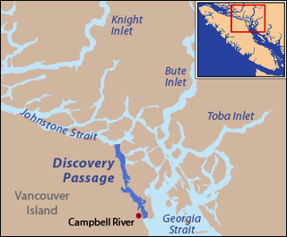
Johnstone Strait is a 110 km (68 mi) channel along the north east coast of Vancouver Island in British Columbia, Canada. Opposite the Vancouver Island coast, running north to south, are Hanson Island, West Cracroft Island, the mainland British Columbia Coast, Hardwicke Island, West Thurlow Island and East Thurlow Island. At that point, the strait meets Discovery Passage which connects to Georgia Strait.

The Bendricks is a stretch of coastline and an important paleontological site in the Vale of Glamorgan in south Wales located along the northern coast of the Bristol Channel between Barry and Sully at 51°23′46″N3°14′50″W. It lies at the foreshore of the industrial port of Barry between the eastern breakwater of the Barry docks entrance on its western edge to Hayes Point on its eastern edge. This area of the coast is a SSSI.
Forward Harbour was a cannery town in the Johnstone Strait region of the Central Coast of British Columbia, Canada, located on the inlet of the same name, which is on the mainland side of Wellbore Channel, to the east of Hardwicke Island. Nearby on the same vicinity on the Mainland, though fronting on other bodies of water, are Jackson Bay to the immediate north, off Sunderland Channel, and Heydon Bay, British Columbia to the east on Loughborough Inlet.
Robson Bight is a small Vancouver Island bay at the west end of Johnstone Strait across from West Cracroft Island in British Columbia, Canada that includes a protected killer whale habitat famous for its whale-rubbing beaches. The bight is adjacent to Lower Tsitika River Provincial Park. The nearest access point is Telegraph Cove on the east coast of Northern Vancouver Island.
Gillian (Gilean) Joan Douglas was a Canadian nature writer. While she was best known for her work as a poet, she was also an accomplished photo journalist, feminist, historian, and politician. Douglas' inspiration for her writing stemmed from her desire to be an independent woman in a patriarchal world. Her writings—her poems, articles, novels, and autobiographies—extend over a period of eighty years, including four marriages, ten years in the Cascade Mountains, and forty years on Cortes Island, British Columbia.

Gilean Alistair Tristram McVean is a professor of statistical genetics at the University of Oxford, director of the Big Data Institute, fellow of Linacre College, Oxford and co-founder and director of Genomics plc. He also co-chaired the 1000 Genomes Project analysis group.
The Hartley Bay Indian Band, also known as the Hartley Bay First Nation, Hartley Bay Band, Gitga'at Nation and Gitga'at First Nation, is the band government of the Gitga'ata people of Hartley Bay, British Columbia, Canada.
The Tlowitsis Nation, formerly the Klowitsis Tribe, the Turnour Island Band and the Tlowitsis-Mumtagila First Nation, is the Indian Act band government of the Ławit'sis (Tlowitsis) tribe of the Kwakwaka'wakw peoples, located in the Queen Charlotte Strait-Johnstone Strait area in the Discovery Islands between Vancouver Island and the British Columbia mainland in Canada. Ławit'sis territory covers parts of northern Vancouver Island, Johnstone Strait, and adjoining inlets of the mainland. Kalugwis, on Turnour Island, was their principal community in times past, but the band's offices are in the city of Campbell River to the southeast. Hanatsa IR No. 6 on Port Neville is the most populated of the band's Indian reserves.

Stewarts Point State Marine Reserve (SMR) and Stewarts Point State Marine Conservation Area (SMCA) are two adjoining marine protected areas that extend offshore from about a mile south of Black Point to Fisk Mill Cove, in Sonoma County on California’s north central coast. The marine protected areas cover 25.22 square miles. Stewarts Point SMR prohibits the take of all living marine resources. Stewarts Point SMCA prohibits the take of all living marine resources, except recreational shore based take of marine aquatic plants, marine invertebrates, finfish by hook and line, surf smelt by beach net, and species authorized by Title 14 Section 28.80 by hand-held dip net.
Columbia Lake Ecological Reserve is a nature reserve on Columbia Lake in the East Kootenay region of British Columbia, Canada, located on the east side of Columbia Lake just north of the village of Canal Flats.
References
- ↑ ""Land, Sea and History" page, Channel Rock website". Archived from the original on 2016-03-04. Retrieved 2019-11-04.
- ↑ Biographical Sketch, p.iii, Gilean Douglas fonds, UBC Special Collections
- ↑ "Gilean Douglas, 1900-1993, "The Douglas Archives" clan history website