
Vancouver Island is an island in the northeastern Pacific Ocean and part of the Canadian province of British Columbia. The island is 456 km (283 mi) in length, 100 km (62 mi) in width at its widest point, and 32,100 km2 (12,400 sq mi) in total area, while 31,285 km2 (12,079 sq mi) are of land. The island is the largest by area and the most populous along the west coasts of the Americas.
The Township of Esquimalt is a municipality at the southern tip of Vancouver Island, in British Columbia, Canada. It is bordered to the east by the provincial capital, Victoria, to the south by the Strait of Juan de Fuca, to the west by Esquimalt Harbour and Royal Roads, to the northwest by the New Songhees 1A Indian reserve and the town of View Royal, and to the north by a narrow inlet of water called the Gorge, across which is the district municipality of Saanich. It is almost tangential to Esquimalt 1 Indian Reserve near Admirals Road. It is one of the 13 municipalities of Greater Victoria and part of the Capital Regional District.

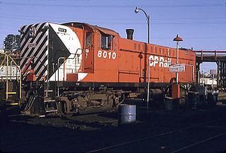
The Island Rail Corridor, previously the Esquimalt & Nanaimo Railway, is a railway operation on Vancouver Island and is the only remaining railway on Vancouver Island after the closure of the Englewood Railway in November 2017. The Island Corridor Foundation owns the former Esquimalt & Nanaimo Railway corridor. The railway line is 225 kilometres (140 mi) in length from Victoria to Courtenay, known as the Victoria Subdivision, with a branch line from Parksville to Port Alberni known as the Port Alberni Subdivision at 64 kilometres (40 mi) in length, for a total 289 kilometres (180 mi) of mainline track. In 2006, the Island Corridor Foundation acquired the railway's ownership from the Canadian Pacific Railway.

Victoria is a federal electoral district in British Columbia, Canada, that has been represented in the House of Commons of Canada from 1872 to 1904 and since 1925.

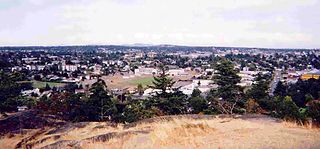
Duncan is a city on southern Vancouver Island in British Columbia, Canada. It is the smallest city by area in Canada. It was incorporated in 1912.

Cowichan Bay is a bay and community located on the east coast of southern Vancouver Island near Duncan, in British Columbia. The mouth of the Cowichan River is near Cowichan Bay. Mount Tzouhalem and its hiking trails and ecological reserve stands to the north. The bay is known for its fishing and scenic value. The area's main industries are fishing and tourism.

Robert Dunsmuir was a Scottish-Canadian coal mine developer, owner and operator, railway developer, industrialist and politician in British Columbia.
Nanaimo was a federal electoral district in British Columbia, Canada, that was represented in the House of Commons of Canada from 1904 to 1979.

Fort Victoria began as a fur trading post of the Hudson’s Bay Company and was the headquarters of HBC operations in the Columbia District, a large fur trading area now part of the province of British Columbia, Canada and the U.S. state of Washington. Construction of Fort Victoria in 1843 highlighted the beginning of a permanent British settlement now known as Victoria, the capital city of British Columbia. The fort itself was demolished in November 1864 as the town continued to grow as a commercial centre serving the local area as well as trading with California, Washington Territory, the United Kingdom, and others.

The Galloping Goose Regional Trail is a 55-kilometre (34 mi) rail trail between Victoria, British Columbia, Canada, and the ghost town of Leechtown, north of Sooke, where it meets the old Sooke Flowline. Maintained by the Capital Regional District (CRD), the trail forms part of the Trans-Canada Trail, and intersects the Lochside Regional Trail. The section from Harbour Road in Esquimalt to the Veterans Memorial Parkway in Langford is also part of the Vancouver Island Trail.
The Baldwin DRS-4-4-1000 was a diesel-electric road switcher produced by the Baldwin Locomotive Works from July, 1948–March, 1950. The units featured a 1,000 horsepower (750 kW), six-cylinder prime mover, and were configured in a B-B wheel arrangement mounted atop a pair of two-axle AAR Type-B road trucks, with all axles powered. They had a cast steel frame. The units were configured to normally run with the long hood in the forward position.
Royal Roads is a roadstead or anchorage located in Strait of Juan de Fuca near the entrance to Esquimalt Harbour in Greater Victoria, British Columbia, Canada.

The Chinatown in Victoria, British Columbia is the oldest Chinatown in Canada and the second oldest in North America after San Francisco. Victoria's Chinatown had its beginnings in the mid-nineteenth century in the mass influx of miners from California to what is now British Columbia in 1858. It remains an actively inhabited place and continues to be popular with residents and visitors, many of whom are Chinese-Canadians. Victoria's Chinatown is now surrounded by cultural, entertainment venues as well as being a venue itself. Chinatown is now conveniently just minutes away from other sites of interests such as the Save-On-Foods Memorial Centre, Bay Centre, Empress Hotel, Market Square, and others.

Fanny Bay is a small hamlet in the Canadian province of British Columbia. It is located on Baynes Sound on the east coast of Vancouver Island. In 2001, its population was listed as 815. It is best known for its fine oysters. The area is served by the Island Highway and Island Rail Corridor.

Fort Rodd Hill National Historic Site is a 19th-century coastal artillery fort on the Colwood, British Columbia side of Esquimalt Harbour,. The site is adjacent to Fisgard Lighthouse National Historic Site, the first lighthouse on the west coast of Canada. Both the fort and lighthouse are managed and presented to the public by Parks Canada.

Victoria Harbour is a harbour, seaport, and seaplane airport in the Canadian city of Victoria, British Columbia. It serves as a cruise ship and ferry destination for tourists and visitors to the city and Vancouver Island. It is both a port of entry and an airport of entry for general aviation. Historically it was a shipbuilding and commercial fishing centre. While the Inner Harbour is fully within the City of Victoria, separating the city's downtown on its east side from the Victoria West neighbourhood, the Upper Harbour serves as the boundary between the City of Victoria and the district municipality of Esquimalt. The inner reaches are also bordered by the district of Saanich and the town of View Royal. Victoria is a federal "public harbour" as defined by Transport Canada. Several port facilities in the harbour are overseen and developed by the Greater Victoria Harbour Authority, however the harbour master's position is with Transport Canada.
Albert Head is a neighbourhood in Metchosin, British Columbia, Canada, part of the Western Communities area of Greater Victoria, British Columbia, Canada. It is located around and named after the headland of Albert Head, which is Department of National Defence property. Canadian Forces Base (CFB) Esquimalt operates CFB Albert Head which contains the British Columbia Canadian Ranger Company of the 4th Canadian Ranger Patrol Group, CFB Esquimalt Range Control, and the Regional Cadet Support Unit (Pacific) which hosts Cadet summer training at the camp. Albert Head Lagoon derives its name from the headland that was named by the Royal Navy for Prince Albert.

Victoria West, commonly called Vic West, is an historic neighbourhood of the city of Victoria, British Columbia, Canada, located just west of downtown across Victoria Harbour, bordering on the Township of Esquimalt.

Victoria station was a railway station in Victoria, British Columbia, on the east end of the Johnson Street Bridge. The station opened in 1888, and was the southern terminus for Via Rail's Dayliner service which operated until 2011. The station closed on August 12, 2011.
