An underground power station is a type of hydroelectric power station constructed by excavating the major components from rock, rather than the more common surface-based construction methods.

The Petty Harbour Hydro Electric Generating Station is a hydroelectric generating station in Petty Harbour–Maddox Cove, Newfoundland and Labrador. It was constructed in 1898 and it was the first hydroelectric generating station in Newfoundland. It was built by the St. John's Street Railway Company, a company established by Robert Reid. Operation commenced on 19 April 1900.
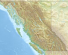
The Stave River is a tributary of the Fraser, joining it at the boundary between the municipalities of Maple Ridge and Mission, about 35 kilometres (22 mi) east of Vancouver, British Columbia, Canada, in the Central Fraser Valley region.

Lake Chelan Dam officially known as the Lake Chelan Hydroelectric Project is located approximately 32 miles (51 km) north of the city of Wenatchee in Chelan County. The dam is located at the lower or southeasterly end of 50.4 miles long Lake Chelan, and is within the limits of the city of Chelan. The powerhouse is located near the community of Chelan Falls. The reservoir has 677,400 acre-feet (835,600,000 m3) of usable water storage. The 10-year average generation for the Project is 365,000 megawatt hours.
The Temengor Dam or Temengor Hydro-Electric Project or Temengor Power Station is a dam in Gerik, Perak, Malaysia. It is located on Perak River about 200 km northeast of Ipoh. Construction of the dam impounded Temenggor Lake.
Sultan Mahmud Power Station or Kenyir Dam is the hydroelectric dam which forms Kenyir Lake, Terengganu, Malaysia. It is located 50 km southwest of Kuala Terengganu on the Kenyir River. The project is a multipurpose hydroelectric power and flood mitigation scheme.
Kakabeka Generating Station is a hydroelectric facility operated by Ontario Power Generation on the bank of the Kaministiquia River, 2 km (1.2 mi) downstream from Kakabeka Falls in the community of Kakabeka Falls, Ontario, 30 km (19 mi) west of Thunder Bay. The plant provides energy to the city of Thunder Bay and area. The station is one of ten hydroelectric stations in Ontario Power Generation's Northwest Plant Group, and is remotely operated from Thunder Bay.

The Caruachi Dam is a concrete gravity dam on the Caroní River in Bolivar state, Venezuela. It supports a hydroelectric power facility with a 2,160 megawatts (2,900,000 hp) capacity. It is about 59 kilometres (37 mi) downstream from the Guri Dam belonging to the Central Hidroeléctrica Simón Bolívar, and about 35 kilometres (22 mi) from where the Caroni and Orinoco rivers meet at Ciudad Guayana.

The Karāpiro Power Station is a hydroelectric power station at Karapiro on the Waikato River, in the North Island of New Zealand. The power station lies on Lake Karapiro, a major rowing regatta venue. Karāpiro is 30 kilometres (19 mi) south-east and upstream from the city of Hamilton and approx. 9 kilometres from Cambridge. It is the last of the eight hydroelectric power stations on the Waikato River.

Ātiamuri Power Station is a hydroelectric power station on the Waikato River, in the North Island of New Zealand. It is the third of eight hydroelectric power stations on the Waikato River. The station can easily be seen from State Highway 1 between Taupō and Tokoroa.
Maraetai Power Station is a hydroelectric power station on the Waikato River, in the North Island of New Zealand. It is the fifth of the eight hydroelectric power stations on the Waikato River, and at 360 MW, is the largest hydroelectric station on the Waikato.

The Upper Kotmale Dam is located in Talawakele, within the Nuwara Eliya District, in the Central Province of Sri Lanka. The dam feeds the third largest hydroelectric power station in the country.

The Koyna Hydroelectric Project is the largest hydroelectric power plant in India, just after the Tehri Dam Project. It is a complex project with four dams including the largest dam on the Koyna River, Maharashtra hence the name Koyna Hydroelectric Project. The project site is in Satara district.

Ruskin Dam is a concrete gravity dam on the Stave River in Ruskin, British Columbia, Canada. The dam was completed in 1930 for the primary purpose of hydroelectric power generation. The dam created Hayward Lake, which supplies water to a 105 MW powerhouse and flooded the Stave's former lower canyon, which ended in a small waterfall approximately where the dam is today.
The Mancotal Dam is an embankment dam on the Tuma River near Asturias in Jinotega Department, Nicaragua. It forms Lake Apanás, the largest reservoir in the country. The primary purpose of the dam is hydroelectric power generation and it supports the 50 MW Centro América Plant. The dam was completed and its first generator commissioned in 1964. The second generator was commissioned a year later on 18 March 1965. To generate power, water from the southwestern end of the Lake Apanás flows along a 4,000 m (13,000 ft) long channel before it enters a series of headrace pipes and a penstock. About 3.4 km (2.1 mi) to the south west the penstock meets Centro América Plant where it turns two 25 MW Francis turbines. After generating power the water is then discharged into the Viejo River. To supplement levels in the Lake Apanás, the El Dorado Dam was completed in 1985 and forms Lake Asturias just downstream of the Mancotal Dam. Water from Lake Asturias can be pumped into Lake Apanás. In 1998 heavy rains from Hurricane Mitch severely damaged the Mancotal and El Dorado Dams, over-topping their spillways and nearly destroying the dams. The Virgen Dam downstream on the Viejo River was destroyed but later rebuilt.

The St. Margaret's Bay Hydroelectric System consists of three hydroelectric power plants and the related lake, dam, and river systems driving them. The system is situated within both Lunenburg County and the Halifax Regional Municipality, beginning approximately 2.5 km (1.6 mi) east of the Head of Saint Margarets Bay and approximately 10 km (6.2 mi) southwest of Hammonds Plains. The system is part of the East Indian River watershed and drains 271 square kilometres (105 sq mi), with water storage provided in Lunenburg County by Mill Lake, Coon Pond, Sandy Lake, Wrights Lake, Big Indian Lake, Five Mile Lake and, at times, an overflow from Pockwock Lake in the Halifax Regional Municipality. The system is owned and operated by Nova Scotia Power Inc.

The Eklutna Dam, also referred to as the New Eklutna Dam or Upper Eklutna Dam, is an embankment dam on the Eklutna River about 30 mi (48 km) northeast of Anchorage in Alaska, United States. The primary purpose of the dam is hydroelectric power generation and it supports a 47 MW power plant. It was first completed in 1929 but was rehabilitated or rebuilt on several occasions over its history. Ownership of the dam and power plant is shared by Chugach Electric and Matanuska Electric.

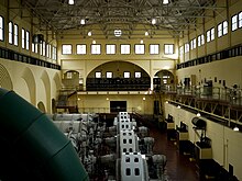
The Snoqualmie Falls Hydroelectric Plant is located just north of Snoqualmie in King County, Washington state, US. It is situated about 22 mi (35 km) east of Seattle. Located just below the Snoqualmie Falls, the power plant consists of two power houses, Plant 1 and Plant 2. Plant 1 was completed in 1899 and is located underground. It is the first completely underground hydroelectric power plant ever built in the world. Plant 2 was built in 1910 and is located along the right bank of the Snoqualmie River. Both plants receive water from a small reservoir created by a weir atop the falls. Plant 1 has an installed capacity of 13.7 MW and Plant 2 a capacity of 40.2 MW for a total installed capacity of 53.9 MW, enough to power 40,000 homes.
Wreck Cove is the largest hydroelectric system in Nova Scotia with a generating capacity of 215.8 MW. Constructed from 1975 to 1978, south of the Cape Breton Highlands National Park, Wreck Cove collects drainage water from 216 square kilometres (83 sq mi) of the Cape Breton Highlands plateau to generate renewable electricity. It consists of two generating stations: the Gisborne Generating Station, with an installed capacity of 3.5 MW, and the Wreck Cove Generating Station, with an installed capacity of 212 MW, producing on average 318 GWh annually—enough energy to power about 30,000 homes.