
The Peace River is a 1,923-kilometre-long (1,195 mi) river in Canada that originates in the Rocky Mountains of northern British Columbia and flows to the northeast through northern Alberta. The Peace River joins the Athabasca River in the Peace-Athabasca Delta to form the Slave River, a tributary of the Mackenzie River. The Finlay River, the main headwater of the Peace River, is regarded as the ultimate source of the Mackenzie River. The combined Finlay–Peace–Slave–Mackenzie river system is the 13th longest river system in the world.

Shuswap Lake is a lake located in the southern interior of British Columbia, Canada that drains via the Little Shuswap River into Little Shuswap Lake. Little Shuswap Lake is the source of the South Thompson River, a branch of the Thompson River, a tributary of the Fraser River. It is at the heart of a region known as the Columbia Shuswap or "the Shuswap", noted for its recreational lakeshore communities including the city of Salmon Arm. The name "Shuswap" is derived from the Shuswap or Secwepemc First Nations people, the most northern of the Interior Salish peoples, whose territory includes the Shuswap. The Shuswap call themselves /ʃǝxwépmǝx/ in their own language, which is called /ʃǝxwepmǝxtʃín/, but the ethnonym's original meaning is now lost.

Garibaldi Provincial Park, also called Garibaldi Park, is a wilderness park located on the coastal mainland of British Columbia, Canada, located 70 kilometres (43.5 mi) north of Vancouver. It was established in 1920 and named a Class A Provincial Park of British Columbia in 1927. The park's natural beauty and rugged landscape, combined with its proximity to urban centres, have made it a popular destination for outdoor recreation, with over 30,000 overnight campers and over 106,000 day users in the 2017/2018 season.
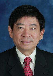
Khaw Boon Wan is a former Singaporean politician who served as the Coordinating Minister for Infrastructure and the Minister for Transport from 1 October 2015 to 26 July 2020 for almost 5 years. He was previously the Chairman of the governing People's Action Party (PAP) from 2011 to 2018 after Lim Boon Heng stepped down from the position. He was previously the Minister for Health from 31 August 2004 to 20 May 2011 and the Minister for National Development from 21 May 2011 to 30 September 2015. He was a Member of Parliament (MP) from 25 October 2001 to 23 June 2020 for almost 20 years.
Inkaneep Provincial Park is a provincial park near Oliver, British Columbia, Canada, located just south of the town of Okanagan Falls. The park contributes to the protection of critical riparian values on the Okanagan River. The park is popular with naturalists, particularly bird-watchers. First Nations have identified the river and riparian area of the park as very important contributor to the long-term viability of the Okanagan River salmon run.
Upper Seymour River Provincial Park is a provincial park in British Columbia, Canada. Located in an isolated area in the interior of the province, 40 kilometres north of the community of Seymour Arm. It protects at the headwaters of the Seymour River, which is the major drainage system into the Seymour Arm of Shuswap Lake.
Pukeashun Provincial Park is a provincial park in British Columbia, Canada, located north of the community of Scotch Creek, near the city of Salmon Arm. The park is named for Pukeashun Mountain which is within its boundaries and a major local landmark. It protects part of the Adams Plateau, the southeastern portion of the Shuswap Highland.

Shuswap Lake Provincial Park is a provincial park in British Columbia, Canada.
Sunnybrae Provincial Park is a provincial park in British Columbia, Canada, located on the northern side of the Salmon Arm of Shuswap Lake, near the city of Salmon Arm. Sunnybrae is a day use park with washrooms, picnic tables, playground and swimming area.

Tudyah Lake Provincial Park is a provincial park in British Columbia, Canada. The park is approximately 56 km south of Mackenzie, BC on Highway 97.
Taylor Arm Provincial Park is a provincial park in British Columbia, Canada, located on the north side of Sproat Lake 23 km northwest of Port Alberni on Vancouver Island. Situated along Highway 4, the 71-hectare park has few services but provides group camping sites, undeveloped beaches, and day-use areas.

Indian Arm is a steep-sided glacial fjord adjacent to the city of Vancouver in southwestern British Columbia. Formed during the last Ice Age, it extends due north from Burrard Inlet, between the communities of Belcarra and the District of North Vancouver, then on into mountainous wilderness. Burrard Inlet and the opening of Indian Arm was mapped by Captain George Vancouver and fully explored days later by Dionisio Alcalá Galiano in June 1792.

Buntzen Lake is a 4.8 kilometres (3 mi) long lake in Anmore, British Columbia, Canada, in the Greater Vancouver area. It is named after the first general manager of the B.C. Electric Co., Johannes Buntzen. There is a smaller lake just to the north named McCombe Lake.
Eagle Mountain, also known as Eagle Ridge, is the mountainous ridge with many indistinct summits between Buntzen Lake and Coquitlam Lake near Coquitlam, British Columbia. Its proximity to Coquitlam, and the houses being built on its southern slopes, make it a very popular weekend destination for hiking, mountain biking, horseback riding, and ATV riding. There is a network of logging roads leading up the south side of the summit to a plateau area with lakes, hiking trails and mountain biking trails.

Mount Elsay is a mountain in southwestern British Columbia, Canada, located near the middle of Mount Seymour Provincial Park in the District of North Vancouver. It is a part of the North Shore Mountains, rising from the shores of Indian Arm to a summit of 1,419 m (4,656 ft). It is named after nearby Elsay Lake and Creek. These names are thought to derive from a Scottish settler, probably after a place name in Scotland.

Elsay Lake is a lake 15 kilometres (9.3 mi) North East of the City of North Vancouver, located near the Centre of Mount Seymour Provincial Park in the District of North Vancouver, British Columbia. Originally named Mystery Lake and still known to some as such. It has subsequently been renamed Lake Elsay, after nearby Elsay Creek. This name is thought to derive from a Scottish settler, probably after a place name in Scotland.
Oregana Creek Provincial Park is a provincial park in British Columbia, Canada, located 150 kilometres northwest of Salmon Arm, British Columbia, near Adams River. The park, which is 286 ha. in size, was established in 2010.
Meung Yum is a Waic language spoken by about 8,000 people in Kunlong Township, Shan State, Burma.
Percy Creek is a stream in the southeastern part of the District of North Vancouver in the Lower Mainland part of British Columbia, Canada. It is in the Pacific Ocean drainage basin and is a right tributary of Indian Arm.


