Tanu, Canada

Last updated

Tanu
The beach at Tanu, Haida Gwaii.jpg
LocationHaida Gwaii, British Columbia, Canada
Coordinates 52°46′00″N131°37′00″W / 52.766634°N 131.616554°W / 52.766634; -131.616554
Governing bodyCouncil of the Haida Nation Parks Canada
Official nameTanu National Historic Site of Canada
Designated1987

Tanu (Haida: T'aanuu llnagaay) is a traditional Haida village site located on Tanu Island, Haida Gwaii, opposite of Kung'a Island in Laskeek Bay, within the Gwaii Haanas National Park Reserve and Haida Heritage Site.

Contents

The village site is designated as a National Historic Site of Canada. [1]

Name

The anglicized name Tanu (anachronistically spelled Tanoo) derives from the Haida (X̱aayda Kil) word t'aanuu, meaning eel grass – referring to the abundant sea grass found at the mouth of the village. Historically, European newcomers commonly referred to the village as “Klue’s Village” (alternatively spelled Kloo, Clue, or Clew), referring to the original town chief, Xe-u (meaning 'Southeast Wind'). [2]

Note that the village New Clew (K’aadas Guu Gandlaay) at Church Creek in the Cumshewa Inlet on Moresby Island is often mistaken for the village of Tanu.

History

Beach and trees at Tanu, Haida Gwaii Beach and trees at Tanu, Haida Gwaii.jpg
Beach and trees at Tanu, Haida Gwaii

According to George F. MacDonald, basing his estimation off of the accounts given by informants to John R. Swanton during the 1900-1901 Jesup Expedition, the town of Tanu likely did not exist earlier than 1735, approximating that the town was in existence for 110 to 165 years before the time of the village’s final resident town chief, G̲itkun John Williams, at the turn of the 20th century. [3]

The first settlers at Tanu arrived from Cumshewa Inlet, of the two closely aligned Eagle lineages, Those-Born-at-Skedans (K’uuna) and the Djigua-Town-People – among the most powerful Eagle families on the islands at the time. [4] The first town chief of Tanu, Xe-u, was a member of the former.

The village was recorded to have a population of 545 inhabitants at around 1840 by John Work of the Hudson’s Bay Company, making it one of the largest in the archipelago. [3] Following multiple waves of epidemics (most notably the 1862 Pacific Northwest smallpox epidemic), the population had been reduced to only 150 inhabitants by 1884, and fell further to 80 individuals by 1887. [5] The decision to relocate was made that year, with the surviving population moving north and establishing the village of New Clew, near the ancestral ‘old story town’ of Djigua. The new village was occupied until 1897; the residents then followed the island-wide consolidation of the Haida people to Graham Island, and settled at the southern town of Skidegate. [6]

Visiting the village in 1883, James G. Swan recorded that there were thirty-one mortuary poles and fifteen mortuary houses, far outnumbering the remaining frontal house poles and longhouses. MacDonald speculates that soon before the relocation to New Clew, the mortuary remains of more than fifty individuals were interred in a mass gravesite at the prompting of Christian missionaries. [7]

Village site

The village site at Tanu, Haida Gwaii. Haida village site under the trees at Tanu.jpg
The village site at Tanu, Haida Gwaii.

Tanu is designated as a Haida Heritage Site by Parks Canada and the Council of the Haida Nation, and the site is co-managed by the joint venture of Gwaii Haanas National Park Reserve and Haida Heritage Site, though it is not included as part of the park reserve due to its zoning within Tanoo Indian Reserve No. 9. [8] [9]

The site today retains three visible house-pits and a number of house-beams along the forest undergrowth, along with a number of monumental poles in various stages of decomposition. It is among the sites covered by the Haida Gwaii Watchmen Program, and has a resident Watchman on-site between May and October each year to welcome visitors and provide information of its history. [10]

Two ancestral frontal poles of the village were removed in the 1930s by B.C. Packers, and moved to Prince Rupert to be displayed in a local park. In response to worsening conditions of the poles, they were relocated in 1965 to the Royal British Columbia Museum in Victoria (which, along with the Museum of Anthropology in Vancouver and the Canadian Museum of History in Gatineau, houses other poles that were taken from Tanu). In 1976, the two poles were among the first Haida cultural artifacts to be reclaimed in repatriation efforts led by the Ḵay Llnagaay Haida Heritage Centre, where they are currently housed in the Xaayda Sahlinda Naay (lit. ‘Saving Things House’). [11]

The ashes of Iljuwas Bill Reid were buried in Tanu following his death in 1998, near the birthplace of his maternal grandmother, Josephine, of the Kaadaas gaah Kiiguwaay Wolf clan Raven moiety. [12] His headstone joins others that have been placed there by descendants of Tanu chiefs living in Skidegate.

Related Research Articles

<span class="mw-page-title-main">Haida people</span> Indigenous group in British Columbia, Canada

Haida are an indigenous group who have traditionally occupied Haida Gwaii, an archipelago just off the coast of British Columbia, Canada, for at least 12,500 years.

<span class="mw-page-title-main">Haida Gwaii</span> Archipelago in British Columbia, Canada

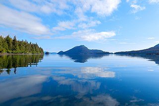
Haida Gwaii, formerly known as the Queen Charlotte Islands, is an archipelago located between 55–125 km (34–78 mi) off the northern Pacific coast of Canada. The islands are separated from the mainland to the east by the shallow Hecate Strait. Queen Charlotte Sound lies to the south, with Vancouver Island beyond. To the north, the disputed Dixon Entrance separates Haida Gwaii from the Alexander Archipelago in the U.S. state of Alaska.

<span class="mw-page-title-main">Gwaii Haanas National Park Reserve and Haida Heritage Site</span> National park reserve and heritage site in British Columbia, Canada

Gwaii Haanas National Park Reserve, National Marine Conservation Area, and Haida Heritage Site, usually referred to simply as Gwaii Haanas, is located in southernmost Haida Gwaii, 130 kilometres off the mainland of British Columbia, Canada. Gwaii Haanas protects an archipelago of 138 islands, the largest being Moresby Island and the southernmost being Kunghit Island. "Gwaii Haanas" means "Islands of Beauty" in X̱aayda kíl, the language of the Haida people.

<span class="mw-page-title-main">Skidegate</span> Indigenous reserve in British Columbia, Canada

Skidegate is a Haida community in Haida Gwaii in British Columbia, Canada. It is on the southeast coast of Graham Island, the largest island in the archipelago, and is approximately 50 kilometres (31 mi) west of mainland British Columbia across Hecate Strait.

<span class="mw-page-title-main">Daajing Giids</span> Village in British Columbia, Canada

Daajing Giids, known as Queen Charlotte City from 1891–2022, is a village municipality in the Haida Gwaii archipelago in the province of British Columbia, Canada. It is located on the southern end of Graham Island at Skidegate Inlet and is a member municipality of the North Coast Regional District.

<span class="mw-page-title-main">Moresby Island</span> Island in Canada

Moresby Island is a large island that forms part of the Haida Gwaii archipelago in British Columbia, Canada, located at 52°45′00″N131°50′00″W. It is separated by the narrow Skidegate Channel from the other principal island of the group to the north, Graham Island.

<span class="mw-page-title-main">New Clew, British Columbia</span> Place in British Columbia, Canada

New Clew, also Clue, Kloo, Kliew, Klue, Clew Indian Reserve, is a locality and First Nations reserve of the Haida people, located on the north shore of Louise Island, which is located in Cumshewa Inlet on Haida Gwaii, formerly known as the Queen Charlotte Islands, of the North Coast of British Columbia, Canada.

<span class="mw-page-title-main">Cumshewa, British Columbia</span> Place in British Columbia, Canada

Cumshewa is a former village of the Haida people located on the north flank of Cumshewa Inlet in the Haida Gwaii of the North Coast of British Columbia, Canada. It is named for Cumshewa, an important Haida chief during the era of the Maritime Fur Trade, as is Cumshewa Head, an important headland and point on the north side of the opening of Cumshewa Inlet, which pierces Moresby Island from the east and was the location of several historical Haida villages.

Cumshewa Inlet, also recorded or referred to in exploration logs as Cumchewas Harbour and Tooscondolth Sound, is a large inlet on the east coast of Moresby Island in the Haida Gwaii islands of the North Coast of British Columbia. The inlet was the site of various Haida villages, including Cumshewa, Tanu and Djí-gua. The name for the inlet was conferred in the days of the Maritime Fur Trade following a custom whereby captains named locations for the most important local chief, in this case Cumshewa, who figures in maritime fur trade vessel logs from 1787 onwards. In 1794 Cumshewa and his followers massacred the crew of the American trading vessel Resolution in Cumshewa Inlet.

<span class="mw-page-title-main">Anthony Island (British Columbia)</span>

Anthony Island is an island located in the southern part of Haida Gwaii, off the North Coast of British Columbia, Canada, to the west of Kunghit Island, the archipelago's southernmost. Anthony Island is noted for being the location of the ruins of SkungWai or SG̱ang Gwaay Llnaagay, commonly called Ninstints after the reigning mid-19th Century chief there. SG̱ang Gwaay Llnagaay was a major village of the Kunghit Haida people.

<span class="mw-page-title-main">Skedans</span> Village in Haida Gwaii

Skedans, also known variously as Koona, Q'una, Koona LLnaagay, K'uuna Llnagaay, Q!o'na Inaga'-I, Q:o'na, and Ḵ'uuna Llnagaay which are variants of its traditional name in the Haida language, is a village located at the head of Cumshewa Inlet in Haida Gwaii, North Coast of British Columbia, Canada. The name Skedans derived by the practice of captains of the maritime fur trade to name villages after their most prominent chiefs.

<span class="mw-page-title-main">Ninstints</span> Haida village site in Haida Gwaii, British Columbia, Canada

SG̱ang Gwaay Llnagaay, commonly known by its English name Ninstints, is a village site of the Haida people and part of the Gwaii Haanas National Park Reserve and Haida Heritage Site on Haida Gwaii on the North Coast of British Columbia, Canada.

<span class="mw-page-title-main">Kung (Haida village)</span> Historic village site in Haida Gwaii

Ḵung is a Haida village, located on the west side of Alexandra Narrows on Graham Island, the largest and northernmost island of Haida Gwaii alongside British Columbia, Canada. Alexandra Narrows, known on some old maps as Mazzaredo Sound, connects Naden Harbour and Virago Sound. An earlier village located at the current village site was named ‘Nightasis’ by the fur trader John Work, and records that in 1840 there were 15 houses with 280 residents.

<span class="mw-page-title-main">Gwaii Haanas National Marine Conservation Area Reserve and Haida Heritage Site</span> National marine conservation area and heritage site in British Columbia, Canada

Gwaii Haanas National Marine Conservation Area Reserve and Haida Heritage Site is a National Marine Conservation Area of Canada. It is located off the coast of the southernmost Haida Gwaii, 130 kilometres off the mainland of British Columbia. It is immediately adjacent to Gwaii Haanas National Park Reserve and Haida Heritage Site. The level of protection differs from that of the National Park Reserve, however, allowing sustainable use of some natural resources in the area. Gwaii Haanas National Marine Conservation Area Reserve, which covers 3,400 square kilometres, is "a primary feeding habitat" of the humpback whale protected by Canada's Species at Risk Act (SARA).

<span class="mw-page-title-main">Haida Heritage Centre</span>

The Haida Heritage Centre is the premier cultural centre and museum of the Haida people. It is located in Skidegate, a community on Graham Island in Haida Gwaii off the Pacific coast of British Columbia, Canada. The centre is situated just south of the site of a historical village in Kay Llnagaay. The Centre was built and is managed by Gwaalagaa Naay, an economic development branch of the Skidegate Band Council, the owners of the site. It is one of the major aboriginal cultural tourism attractions in Haida Gwaii and has been described as "a place for the Haida voice to be heard." Educational programs are offered in partnership with School District 50 Haida Gwaii, the University of Northern British Columbia, and with the Haida Gwaii Higher Education Society.

<span class="mw-page-title-main">Hlk'yah G̱awG̱a</span>

Hlk'yah G̱awG̱a, also known as Windy Bay, is located on Athlii Gwaii in southern Haida Gwaii, British Columbia. The site was historically the location of a Haida village named Hlk'yah Llnagaay, meaning Peregrine Falcon Town in English. In the 1980s, Hlk'yah G̱awG̱a was the focus of a series of lawsuits and protests opposing clearcut logging on the island. These demonstrations were the impetus for the signing of the Gwaii Haanas Agreement of 1993 and the creation of the Gwaii Haanas National Park Reserve, National Marine Conservation Area Reserve, and Haida Heritage Site.

Kiusta located on Haida Gwaii is the oldest Northern Haida village: and the site of first recorded contact between the Haida and Europeans in 1774. Haida lived in this village for thousands of years, due to the sheltered nature of its location it was used for boats offloading, especially in rough waters. Kiusta is one of the oldest archeological sites of human use in British Columbia, and continues to be a site for cultural revitalisation.

<span class="mw-page-title-main">Colonial police action against the people of Haida Gwaii</span>

Various Imperial and colonial actions against Haida Gwaii Authorities have been undertaken since the 19th century. The indigenous peoples of Haida Gwaii often reacted violently to European and American ships which trespassed in their waters and lands. From the 18th to 19th centuries, various skirmishes took place between Haida authorities and European and American merchantmen and warships. Canadian settlers did not arrive on Haida Gwaii islands until 1900, and many Canadian colonial police actions attempted to assault the Haida Gwaii authorities and citizens. The indigenous Haida population was decimated by diseases such as smallpox which were introduced accidentally by way of Fort Victoria. The presence of foreign diseases, to which the Haida had no immunity, along with some colonial hostility, meant that the numbers of Haida citizens was reduced from tens of thousands to 588 by 1915. This erosion of Haida cultural institutions was essential to open the way for subsequent British and Canadian incursions and jurisdictional claims.

Chaatl, also spelled Cha'atl, Tsaa'ahl, Tts’aa’ahl, and other variations, was a historic Haida village located on the shore of Chaatl Island, facing south across Buck Channel to the western side of northern Moresby Island, near the western end of Skidegate Channel, Haida Gwaii, British Columbia, Canada. Across Buck Channel from Chaatl was the long-abandoned village site of Niisii. There were close connections between Chaatl and the nearby village of Kaisun, about 10 km (6.2 mi) to the south in a straight line, or about 20 km (12 mi) by water.

References

  1. "Tanu National Historic Site of Canada" . Retrieved September 17, 2017.
  2. Swanton, John R. (1905). Contributions to the ethnology of the Haida. New York: G. E. Stechert & Co. pp. 96, 269. ISBN   9780404581053. OCLC   1229349.
  3. 1 2 F., MacDonald, George (1989). Chiefs of the sea and sky : Haida heritage sites of the Queen Charlotte Islands. Vancouver [B.C.]: University of British Columbia Press. p. 90. ISBN   9780774803311. OCLC   243573131.{{cite book}}: CS1 maint: multiple names: authors list (link)
  4. Swanton, John R. (1905). Contributions to the ethnology of the Haida. New York: G. E. Stechert & Co. pp. 96–97. ISBN   9780404581053. OCLC   1229349.
  5. Gill, Ian (1997). Haida Gwaii : journeys through the Queen Charlotte Islands. Nunuk, David. Vancouver: Raincoast Books. pp. 134–136. ISBN   9781551920689. OCLC   37713417.
  6. Horwood, Dennis (2006). Haida Gwaii the Queen Charlotte Islands. Parkin, Tom, 1953- (2nd ed.). Surrey, B.C.: Heritage House. pp. 123–124. ISBN   9781459329690. OCLC   277235937.
  7. F., MacDonald, George (1996). Haida art. Canadian Museum of Civilization. Seattle: University of Washington Press. pp. 145–146. ISBN   029597561X. OCLC   34517368.{{cite book}}: CS1 maint: multiple names: authors list (link)
  8. Canada, Parks Canada Agency, Government of. "T'aanuu Llnagaay (Tanu) - Gwaii Haanas National Park Reserve, National Marine Conservation Area Reserve, and Haida Heritage Site". www.pc.gc.ca. Retrieved September 17, 2017.{{cite web}}: CS1 maint: multiple names: authors list (link)
  9. Branch, Government of Canada; Indigenous and Northern Affairs Canada; Communications (November 3, 2008). "Home". Crown–Indigenous Relations and Northern Affairs Canada . Government of Canada. Retrieved September 17, 2017.{{cite web}}: CS1 maint: multiple names: authors list (link)
  10. Canada, Parks Canada Agency, Government of. "Haida Gwaii Watchmen - Gwaii Haanas National Park Reserve, National Marine Conservation Area Reserve, and Haida Heritage Site". www.pc.gc.ca. Retrieved September 17, 2017.{{cite web}}: CS1 maint: multiple names: authors list (link)
  11. "The Centre | Haida Heritage Centre". haidaheritagecentre.com. Retrieved September 17, 2017.
  12. Bill Reid and the Haida canoe. Reid, Martine Jeanne, 1945-. Madeira Park, B.C.: Harbour Pub. 2011. pp. 122–126. ISBN   978-1550175585. OCLC   741538608.{{cite book}}: CS1 maint: others (link)