List of Gram Panchayats in Malappuram district

Last updated

Gram Panchayats of Malappuram
Legislative Assembly Constituencies of Malappuram 1.svg
Local Self Government Institutions in the district
Category Gram Panchayats
Location Malappuram district
Number94 Gram Panchayats
Government
Subdivisions

Malappuram is one of the 14 districts in the southern Indian state of Kerala. Kerala, with appreciative development indicators comparable to developed countries, has been experimenting with decentralization and participatory local democracy, ultimately aimed at the realization of the constitutional goal of establishing genuine "institutions of local self-government" since the enactment of Kerala Panchayat Raj Act & The Kerala Municipality Act in the year 1994. Gram Panchayats are the basic units of rural governance in the decentralized system. [1]

Contents

Overview

Malappuram is the most populous and the third-largest district in the state. [2] The rural district is divided into 94 Gram Panchayats which are included in 15 blocks namely Areekode, Kalikavu, Kondotty, Kuttippuram, Malappuram, Mankada, Nilambur, Perinthalmanna, Perumpadappu, Ponnani, Tanur, Tirur, Tirurangadi, Vengara, and Wandoor. [3] These blocks combine to form the Malappuram district Panchayat, which is the apex district body of rural governance. Malappuram District Panchayat is the largest District Panchayat as well as the largest local self-government body in the state. The 94 Gram Panchayats are again divided into 1,778 wards. [4] Census towns (small towns with urban features) also come under the jurisdiction of Gram Panchayats. Though the draft notifications for the formation of new Gram Panchayats namely Anamangad, Ananthavoor, Arakkuparamba, Ariyallur, Chembrassery, Elankur, Karipur, Kootayi, Kurumbalangode, Marutha, Pang, Vaniyambalam, and Velimukku were published in 2015, they are yet to be formed. [5] With their formation, the number of Gram Panchayats in the district will become 106.

List of Gram Panchayats in the district

An election map showing the results of 2020 Kerala local elections in Malappuram district 2020 Kerala Local body Elections - Malappuram District (Gram Panchayats and Municipalities).svg
An election map showing the results of 2020 Kerala local elections in Malappuram district
Distribution of Population in Local Bodies (2011) Distribution of Population in Malappuram District.svg
Distribution of Population in Local Bodies (2011)
Gram PanchayatArea
(in km2)
Population
(2011)
Wards Taluk Ruling
Alliance [6]
Areekode Block UDF
1 Areekode 12.2131,56318 Eranad    UDF
2 Cheekkode 23.9632,86718 Kondotty    UDF
3 Edavanna 52.1046,12822 Eranad    LDF
4 Kavanoor 31.3037,97719 Eranad    UDF
5 Kizhuparamba 14.9922,06214 Eranad    UDF
6 Kuzhimanna 22.0534,41318 Kondotty    UDF
7 Pulpatta 30.1242,68321 Eranad    UDF
8 Urangattiri 76.0940,31821 Eranad    UDF
Kalikavu Block UDF
9 Amarambalam 84.6435,97519 Nilambur    LDF
10 Chokkad 76.0832,22418 Nilambur    UDF
11 Edappatta 25.7722,72915 Perinthalmanna    UDF
12 Kalikavu 92.0035,21019 Nilambur    UDF
13 Karulai 131.3123,27715 Nilambur    UDF
14 Karuvarakundu 78.6941,58321 Nilambur    LDF
15 Tuvvur 31.3840,29717 Nilambur    UDF
Kondotty Block UDF
16 Chelembra 15.9134,14918 Kondotty    UDF
17 Cherukavu 16.8736,77319 Kondotty    UDF
18 Muthuvallur 21.4926,02815 Kondotty    UDF
19 Pallikkal 25.9646,96222 Kondotty    UDF
20 Pulikkal 28.7040,13321 Kondotty    LDF
21 Vazhayur 21.1930,26217 Kondotty    LDF
22 Vazhakkad 23.8935,77419 Kondotty    UDF
Kuttippuram Block UDF
23 Athavanad 26.7741,18722 Tirur    UDF
24 Edayur 30.4336,49819 Tirur    UDF
25 Irimbiliyam 24.0630,63517 Tirur    UDF
26 Kalpakanchery 16.2533,72119 Tirur    UDF
27 Kuttippuram 31.3247,02323 Tirur    UDF
28 Marakkara 27.0040,40420 Tirur    UDF
Malappuram Block UDF
29 Anakkayam 45.2350,63423 Eranad    UDF
30 Kodur 18.4238,25819 Perinthalmanna    UDF
31 Morayur 24.5725,26118 Kondotty    UDF
32 Othukkungal 17.2839,13920 Tirurangadi    UDF
33 Ponmala 21.6533,92218 Tirur    UDF
34 Pookkottur 20.6328,07719 Eranad    UDF
Mankada Block UDF
35 Koottilangadi 21.5436,60219 Perinthalmanna    UDF
36 Kuruva 35.7745,35422 Perinthalmanna    UDF
37 Makkaraparamba 11.1718,70213 Perinthalmanna    UDF
38 Mankada 31.0032,74818 Perinthalmanna    UDF
39 Moorkanad 17.6036,32419 Perinthalmanna    LDF
40 Puzhakkattiri 22.7229,88617 Perinthalmanna    UDF
Nilambur Block UDF
41Chaliyar125.0020,83414 Nilambur    LDF
42 Chungathara 129.6936,26920 Nilambur    UDF
43 Edakkara 58.0928,16216 Nilambur    UDF
44 Moothedam 48.0033,96015 Nilambur    UDF
45 Pothukal 77.0029,56117 Nilambur    LDF
46 Vazhikkadavu 114.0047,32223 Nilambur    UDF
Perinthalmanna Block UDF
47 Aliparamba 34.3741,72521 Perinthalmanna    UDF
48 Angadipuram 38.5056,45123 Perinthalmanna    UDF
49 Elamkulam 21.3126,45616 Perinthalmanna    UDF
50 Keezhattur 40.0036,31719 Perinthalmanna    UDF
51 Melattur 27.2427,25016 Perinthalmanna    LDF
52 Pulamantol 32.1537,78520 Perinthalmanna    LDF
53 Thazhekode 45.0241,98221 Perinthalmanna    LDF
54 Vettathur 35.8437,45616 Perinthalmanna    UDF
Perumpadappu Block LDF
55 Alamkode 20.5033,91819 Ponnani    LDF
56 Maranchery 20.4735,01119 Ponnani    LDF
57 Nannamukku 19.3528,98917 Ponnani    LDF
58 Perumpadappu 15.0229,76618 Ponnani    LDF
59 Veliyankode 15.1532,55418 Ponnani    UDF
Ponnani Block LDF
60 Edappal 23.7032,55019 Ponnani    LDF
61 Vattamkulam 20.7336,14719 Ponnani    UDF
62 Thavanur 25.2834,50019 Ponnani    LDF
63 Kalady 16.4825,87216 Ponnani    UDF
Tanur Block UDF
64 Cheriyamundam 11.9531,21218 Tirur    UDF
65 Niramaruthur 9.2029,84617 Tirur    LDF
66 Ozhur 15.9234,01618 Tirur    UDF
67 Perumanna-Klari 11.4827,27816 Tirur    UDF
68 Ponmundam 9.1625,85516 Tirur    UDF
69 Tanalur 15.1247,97623 Tirur    LDF
70 Valavannur 15.2833,15919 Tirur    UDF
Tirur Block LDF
71 Purathur 19.5031,91519 Tirur    LDF
72 Thalakkad 16.3035,82019 Tirur    LDF
73 Tirunavaya 19.5945,84823 Tirur    UDF
74 Triprangode 20.6741,16721 Tirur    LDF
75 Vettom 13.4628,10420 Tirur    LDF
76 Mangalam 12.1733,44220 Tirur    UDF
Tirurangadi Block UDF
77 Moonniyur 22.6655,53523 Tirurangadi    UDF
78 Nannambra 18.3540,54321 Tirurangadi    UDF
79 Vallikkunnu 25.1448,00623 Tirurangadi    LDF
80 Thenhipalam 17.9832,04517 Tirurangadi    UDF
81 Peruvallur 21.1934,94119 Tirurangadi    UDF
Vengara Block UDF
82 Abdu Rahiman Nagar 14.8341,99321 Tirurangadi    UDF
83 Edarikode 15.6527,35616 Tirurangadi    UDF
84Kannamangalam28.2441,26020 Tirurangadi    UDF
85 Oorakam 21.6529,15717 Tirurangadi    UDF
86 Parappur 18.5036,27019 Tirurangadi    UDF
87 Thennala 10.0029,19017 Tirurangadi    UDF
88 Vengara 18.6648,60023 Tirurangadi    UDF
Wandoor Block UDF
89 Mampad 84.6737,22119 Nilambur    LDF
90 Pandikkad 57.0155,21323 Eranad    UDF
91 Porur 35.6037,63617 Nilambur    UDF
92 Thiruvali 33.8327,73416 Nilambur    LDF
93 Trikkalangode 59.9952,09023 Eranad    UDF
94 Wandoor 45.4549,01323 Nilambur    UDF
Sources: 2011 Census of India, [7] Government of Kerala [8]

See also

Related Research Articles

<span class="mw-page-title-main">Malappuram district</span> District in Kerala, India

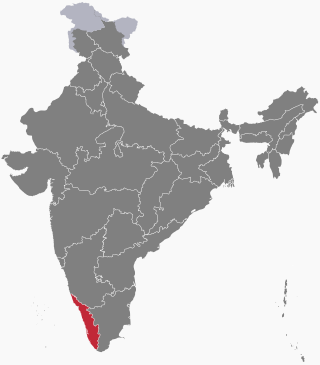
Malappuram, is one of the 14 districts in the Indian state of Kerala, with a coastline of 70 km (43 mi). The most populous district of Kerala, Malappuram is home to around 13% of the total population of the state. The district was formed on 16 June 1969, spanning an area of about 3,554 km2 (1,372 sq mi). It is the third-largest district of Kerala by area. It is bounded by Western Ghats and the Arabian Sea on either side. The district is divided into seven Taluks: Eranad, Kondotty, Nilambur, Perinthalmanna, Ponnani, Tirur, and Tirurangadi.

Gram Panchayat is a basic governing institution in Indian villages. It is a political institution, acting as the cabinet of a village. The Gram Sabha works as the general body of the Gram Panchayat. The members of the gram panchayat are elected directly by the people. The president of a gram panchayat is known as a "Pradhan" or "Sarpanch". There are about 250,000 gram panchayats present in India.

<span class="mw-page-title-main">Elections in Kerala</span>

Elections in Kerala are regularly held to appoint government officials at various levels, both within the state of Kerala and in India as a whole. These elections encompass national elections as well as regional elections for local bodies and panchayats.

Panchayat samiti or block panchayat is a rural local government (panchayat) body at the intermediate tehsil (taluka/mandal) or block level in India. It works for the villages of the tehsil that together are called a development block. It has been said to be the "panchayat of panchayats".

<span class="mw-page-title-main">Panchayati raj in India</span> Village self-government system in rural India

Panchayati raj is the system of local self-government of villages in rural India as opposed to urban and suburban municipalities.

<span class="mw-page-title-main">Ramanattukara</span> Municipality/Suburb in Kozhikode, Kerala, India

Ramanattukara is a municipality census town in Kozhikode district in the Indian state of Kerala. This town was formerly called Kadungan Chira village. Ramanattukara is located 15 km away from Kozhikode city.

<span class="mw-page-title-main">Mankada</span> Village in Kerala, India

Mankada is a hillside village in the Malappuram district of Kerala state. It is located 15 km (9.3 mi) from Malappuram and is part of the Malappuram parliament constituency. The municipal town of Perinthalmanna is just 10 km (6.2 mi) away. Also, the municipal towns of Manjeri and Malappuram are just 15 km (9.3 mi) away. Mankada Kadannamanna Kovilakam was the seat of ruling family of the erstwhile Kingdom of Valluvanad.

Local government. in Maharashtra State follows the general structure of Local Governance in India and is broadly classified into two categories: Urban Local Governance and Rural Local Governance.

<span class="mw-page-title-main">Valanchery</span> Town in Kerala, India +91

Valanchery is a major municipal town in Malappuram district, Kerala, India. It is one of the four municipalities in Tirur Taluk, besides Tirur, Kottakkal, and Tanur. It is situated about 40 kilometres (25 mi) southeast to Karipur International Airport and 25 kilometres (16 mi) southwards to the district headquarters, and forms a part of Malappuram metropolitan area. It is also one of the major commercial towns under the Malappuram urban agglomeration. Valanchery, which was a part of the erstwhile princely state of the Valluvanad in the early medieval period, had been under the direct control of the Zamorin of Calicut following the Tirunavaya war of 14th century CE. During British Raj, Valanchery was included in the Ponnani Taluk of erstwhile Malabar District.

Kerala is a state on the southwestern coast of India. It is known for its high literacy rate, low infant mortality rate, and long life expectancy. Kerala has also been a pioneer in the field of decentralization and participatory local democracy.

<span class="mw-page-title-main">Kalpakanchery</span> Village in Kerala, India

Kalpakanchery is a revenue village and a Gram Panchayat in Tirur Taluk, Malappuram district, Kerala, India. The village is located 21 kilometres (13 mi) south-west to the city of Malappuram.

Local government in India is governmental jurisdiction below the level of the state. Local self-government means that residents in towns, villages and rural settlements are the people who elect local councils and their heads authorising them to solve the important issues. India is a federal republic with three spheres of government: central, state and local. The 73rd and 74th constitutional amendments give recognition and protection to local governments and in addition each state has its own local government legislation. Since 1992, local government in India takes place in two very distinct forms. Urban localities, covered in the 74th amendment to the Constitution, have Nagar Palika but derive their powers from the individual state governments, while the powers of rural localities have been formalized under the panchayati raj system, under the 73rd amendment to the Constitution.

<span class="mw-page-title-main">Perinthalmanna</span> Town in Kerala, India

Perinthalmanna is a major town and municipality in Malappuram district, Kerala, India. It serves as the administrative centre for the Perinthalmanna taluk, as well as a revenue division, a community development block, and a police sub-division bearing the same name. It was formerly the headquarters of Valluvanad Taluk, which was one of the two Taluks in the Malappuram Revenue Division of the erstwhile Malabar District during the British Raj. The city is located 23 kilometres (14 mi) southwest to the city of Malappuram at the centre of the Kozhikode–Malappuram–Perinthalmanna–Palakkad National Highway 966.

Parali Grama panchayat is a gram panchayat in the Palakkad district, state of Kerala, India. It is a local government organization that serves the villages of Parli-I and Parli-II.

<span class="mw-page-title-main">Panchayati raj</span> Indian political system

The Panchayat raj is a political system, originating from the Indian subcontinent, found mainly in India, Pakistan, Bangladesh, Sri Lanka, and Nepal. It is one of the oldest systems of local government in the Indian subcontinent, and historical mentions date to around 250 CE. The word raj means "rule" and panchayat means "assembly" (ayat) of five (panch). Traditionally, Panchayats consisted of wise and respected elders chosen and accepted by the local community. These assemblies settled disputes between both individuals and villages. However, there were varying forms of such assemblies.

<span class="mw-page-title-main">Administration of Malappuram district</span>

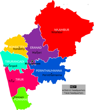
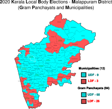
The Malappuram district has four types of administrative hierarchies:

<span class="mw-page-title-main">Perumanna-Klari</span> Census town in Kerala, India

Perumanna-Klari, also known as Perumanna, is a census town and a Gram panchayat in Tirur Taluk, Malappuram district, Kerala, India. The village is located 39 kilometres (24 mi) south-west of the city of Malappuram.

<span class="mw-page-title-main">Kuttippuram Block Panchayat</span>

The Kuttippuram Block Panchayat is the block-level administrative body that administers the region around Kuttippuram in Malappuram district, Kerala, India. It is also one of the 15 Block Panchayats established for the proper block-level administration of Gram panchayats in the district. Established in 1962, the block's current president is Vaseema Veleri since 2020. Kuttippuram Block Panchayat lies in two assembly constituencies – Kottakkal and Tirur – both of which are part of the Ponnani parliamentary constituency. The Block is headed by a President and council, and manages 155.83 km2 of Kuttippuram block, with a population of about 229,468 within that area.

Kayyur–Cheemeni Grama Panchayat is a Gram Panchayat in Kasargod district of Kerala. The gram panchayat, which covers an area of 72.70 km2 and is located in the Neeleswaram block of Hosdurg taluk in Kasaragod district. This gram panchayat includes Kayyur, Cheemeni, Thimiri and Klayikode villages. There are 16 wards in this gram panchayat.

References

  1. "Panchayati Raj System in India | Definition, Examples, Diagrams". www.toppr.com. Retrieved 4 December 2020.
  2. "Population profile of Kerala". spb.kerala.gov.in.
  3. "Rural administration in Malappuram district". Official website of Malappuram district. Retrieved 2 August 2020.
  4. "Gram Panchayats and wards in Malappuram". Local self-government department, Government of Kerala. Retrieved 3 August 2020.
  5. "Draft notifications for new local bodies in Malappuram". Delimitation Commission, Kerala. Government of Kerala. Retrieved 10 October 2020.
  6. "LSGI Election - 2020 (Gram Panchayats in Malappuram district)". lsgkerala.gov.in. Retrieved 2021-02-20.
  7. "Taluk-wise demography of Malappuram" (PDF). censusindia.gov.in. Directorate of Census Operations, Kerala. pp. 161–193. Retrieved 19 April 2020.
  8. "Villages in Malappuram". lsgkerala.gov.in. Retrieved 2 August 2020.