Anangpur is a historical village located near Faridabad in Haryana, India. Anangpur forms a geographical triangle along with Mehrauli and Tugluqabad. It was the earliest settlement of the Tomar Rajput.[1] Anangpur was the capital of Anangpal Tomar who had built the fort and monuments here.[2][3][4]
Anangpal I, first king of Tomara dynasty (c.736- 1052 CE), declared himself an independent ruler and established the Tomara dynasty of Delhi in the early 8th century.[5] He built his capital in this village and expanded his kingdom from there. He is said to have built numerous palaces and temples during his reign, the majority of which are diminished now.[2] Last king of this dynasty was Anangpal (Anangpal II), who had built Delhi's Lal Kot, which was later renovated by Chauhan ruler and also came to be known as the Qila Rai Pithora. Tomara dynasty were overthrown by Chahamanas of Shakambhari, last Chahamana or Chauhan king was Prithviraj Chauhan, Qila Rai Pithora (earlier called Lal Kot) is named after him.[citation needed]
The capital of Tanwar changed a few times during the course of 457 years they ruled in the northern India. The first capital of the Tomar empire was Anangpur while the last one was Dhillikapuri (Delhi, Lal Kot).[6]
Chauhan dynasty (12th century CE)
The Tomara's rule was followed by that of the Chahamanas and Shihab ad-Din.[7]
Anangpur Group of Paleolithic Sites (AGPS): Discovered in 1986, - Mangar Bani near Delhi may extend AGPS, dating back to the **Mesolithic and Paleolithic eras. Mangar Bani: Located in the Aravalli hills, Mangar Bani houses ancient rock paintings and tools and is under advocacy for its biodiversity and historical value. Tools and Artifacts: The tools found follow an Acheulean tradition, with Mangar Bani being among the largest Paleolithic sites in Asia.
Anangpur group of paleolithic sites (AGPS), discovered In 1986, is a cluster of 43 prehistoric sites with rock art (paintings) in the area of historic Anangpur village, Mangar Bani Paleolithic site found in 2021 might be an extension of Anangpur sites.[8]
In the forested area where the Surajkund and the Anagpur Dam are located, ancient Stone Age relics have been found which are microliths (stone tools) belonging to the Lower Paleolithic era.[9] From a study of the prehistoric findings along the ridges of Surajkund reservoir, Anagpur Dam, and around Delhi and adjoining parts of Haryana, it has been inferred that the southern hilly area of Delhi and Haryana was environmentally suited for pre-historic man to settle here.[10]
List of sites
These were found at 43 sites from Ankhir (a village 17km east of Mangar Bani) in south to north along the Anangpur-Angnpur Dam-Surajkund-Tughlaqabad axis. These sites are on the 'Tughlaqabad-Surajkund Road' and south of 'Surajkund-Faridabad Road', on Anangpur hills, and on Ankhir hill, and on the road embracing the low ridge from Faridabad (Ankhir) to Surajkund.[9] These sites include Ankhir, Anangpur, Anangpur Dam, Shilakhari, Mangar Bani, Dhauj, Kot, Nurpur, Dhumaspur, Surajkund, etc.[8]
One of these sites is at Kot village, northeast of Sohna and southwest of Dhauj, where prehistoric paintings on stones and tools, such as chisel, have been found. Haryana surveyed the site in 2021, and ASI surveyed and photographed the site in June 2023.[11]
Protected status
As of 31 July 2021, Head of HAD, Ashok Khemka, informed that proposal to notify this entire area as protected archaeological site has been sent by Haryana Archaeological Dept (HAD) to Govt of Haryana (GoH), and HAD is awaiting gazette notification by the GoH after which this site will become legally protected. Meanwhile, district land and revenue administration of Faridabad was undertaking ground truthing exercise, to verify the data, to ascertain the landscape and confirm the type and ownership of the land, which will be sent to HAD to help with attainment of protected status and consequent conservation.[8]
Conservation
Khemka asserted that HAD will engage National Research Laboratory for Conservation of Cultural Property (NRLC) Lucknow, Birbal Sahni Institute of Palaeosciences (BSIP) Lucknow, Physical Research Laboratory (PRL) Ahmedabad for conservation of rockart and paintings. Khemka asserted that the whole area will be extensively surveyed to find any additional sites, entire area of Delhi South Ridge of Aravali in Haryana between Gurugram and Faridabad will be mapped and each site will be GPS tagged. Large scale scientific excavations, scientific dating of paintings and excavated sediments will be undertaken.[8]
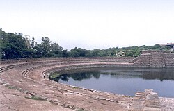
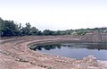
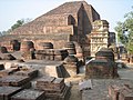
Anangpur Dam is an Indian hydraulic engineering structure built during his reign and the ruins of a fortification can also be seen around it. Surajkund, a large masonry tank, can be found in this area dating from the 9th century and was used to collect water from the Anangpur Dam and the surrounding areal.[12][13]
Downstream view of the dam.
Top view of the dam, entry holes dam of the gallery inside the dam wall.
Top view of the dam, steps into the gallery inside the dam.
Sluice inlet in the dam - on upstream side of the dam while looking from upstream towards downstream.
Sluice outlet from the dam - on upstream side of the dam while looking from downstream side towards upstream.
Surajkund is known for its annual fair Surajkund International Craft Mela, 2015 edition of this fair was visited by 1.2 million visitors including 160,000 foreigners with more than 20 countries participating in it.[18]
Suraj Kund panorama.
Suraj Kund - view.
Suraj Kund - another view.
Surajkund International Crafts Fair
Rakasthani folk dance at Surajkund International Crafts Fair
Present day Anangpur village
Administration and demography
Present Anangpur (Postal Index Number 121003[19]) has a population of around 30000+ people, an area of 10.55 square kilometers, and a population density of 3332 per Kilometer square.[20]
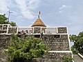
Hari Parbat Mandir
Anangpur has a replica of the temple of Mata Sharika Chakreshwar Hari Parbat Srinagar. Hari Parbat Mandir Anangpur is situated at one of the hillocks adjoining the Anangpur village. The temple was built with the contribution of Padma ShriJagan Nath Kaul, who was the President of the Kashmiri Sewak Samaj, Faridabad and All India Kashmiri Samaj.[21] The temple 'Hari Parbat' Anangpur is a place where 'Kashmiri Pandits' in and around Delhi observe their 'Nav Reh' festival.[22][23]
↑The Chauhan (Cahamanas) Rajputs had emerged in the later tenth century and established themselves as a paramount power, overthrowing the Tomar Rajputs. In 1151 the Tomar Rajput rulers (and original builders) of Delhi were overthrown by Visala Dev, the Chauhan ruler of Ajmer. Meo settlement in this area by the tenth century is recorded by the gazetteers of the United Provinces as also their displacement by Rajput clans such as the Dors, Tomars, Bargujars, and Chauhans. These Rajput clans were characterized by a tremendous mobility and search for territory., Shail Mayaram (2006). Against History, Against State. Permanent Black. ISBN978-81-7824-152-4.{{cite book}}: CS1 maint: multiple names: authors list (link) CS1 maint: numeric names: authors list (link)
↑Sharma, Arun Kumar (1993). Prehistoric Delhi and Its Neighbourhood. Aryan Books International. ISBN978-81-7305-016-9. The palaeolithic site of Anangpur (Arangpur – 28°27' 30"N., 15°56"E), district Faridabad in Haryana State of India is located nearly 30 kms south of Delhi beyond Surajkund lake.
↑According to bardic tradition, the dynasty was one of the 36 Rajput tribes. The history of the family spans the period between the reign of Anangapala, who founded the city of Delhi in the 11th century CE, and the incorporation of Delhi within the Chauhan (Chahamana) kingdom in 1164. "Tomara dynasty | Indian dynasty". Encyclopedia Britannica. Retrieved 17 June 2021.{{cite web}}: CS1 maint: multiple names: authors list (link) CS1 maint: numeric names: authors list (link)
↑Thapliyal, Uma Prasad (1987). Gazetteer of Rural Delhi. Gazetteer Unit, Delhi Administration. p.413.
↑Tanwars of Delhi by Harihar Niwas Dwivedi. Gwalior: Vidya Mandir Publications. 1983.
↑Sharma, Y.D (2001). Delhi and its Neighbourhood. New Delhi: Archaeological Survey of India. p.100 in 161. Archived from the original on 31 August 2005. Retrieved 5 September 2009. Page 100: Suraj Kund lies about 3km south-east of Tughlaqabad in district Gurgaon---The reservoir is believed to have been constructed in the tenth century by King Surjapal of Tomar dynasty. Page 101: About 2km south-west of Surajkund, close to the village of Anagpur (also called Arangpur) is a dam ascribed to Anagpal of the Tomar Dynasty, who is also credited with building the Lal Kot{{cite book}}: |work= ignored (help)
This page is based on this Wikipedia article Text is available under the CC BY-SA 4.0 license; additional terms may apply. Images, videos and audio are available under their respective licenses.