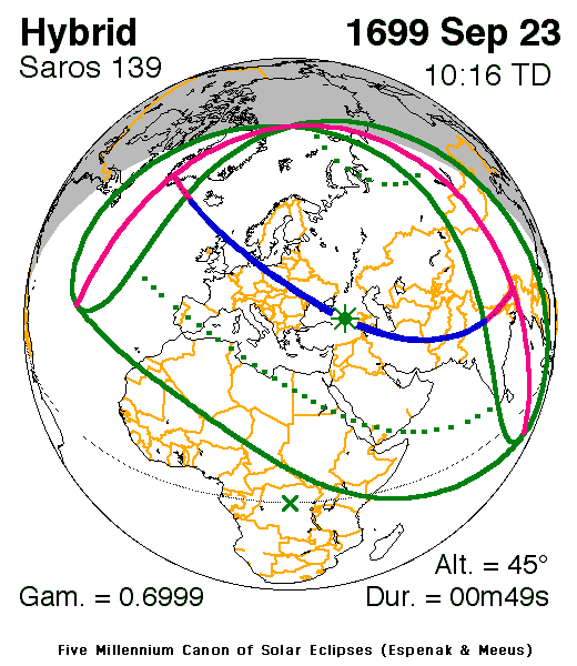
| Hybrid eclipse | |
 Map | |
| Gamma | 0.6999 |
|---|---|
| Magnitude | 1.0095 |
| Maximum eclipse | |
| Duration | 49 s (0 min 49 s) |
| Coordinates | 41°48′N40°42′E / 41.8°N 40.7°E |
| Max. width of band | 46 km (29 mi) |
| Times (UTC) | |
| Greatest eclipse | 10:16:12 |
| References | |
| Saros | 139 (12 of 71) |
| Catalog # (SE5000) | 8786 |
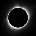
A total solar eclipse occurred on September 23, 1699. [1] A solar eclipse occurs when the Moon passes between Earth and the Sun, thereby totally or partly obscuring the image of the Sun for a viewer on Earth. A total solar eclipse occurs when the Moon's apparent diameter is larger than the Sun's, [2] blocking all direct sunlight, turning day into darkness. Totality occurs in a narrow path across Earth's surface, with the partial solar eclipse visible over a surrounding region thousands of kilometres wide.
Contents
A narrow path of totality just clipped the north-east corner of Scotland, including Wick. [3]
Giovanni Domenico Cassini produced the first ever map of a solar eclipse for this event, showing the line of centrality, partial eclipse, and the limits of the eclipse. [4] [5] In Scotland, the eclipse was total to the north of Caithness for a brief interval, and a near total eclipse was observed in Edinburgh. [6] [7] From England, Samuel Pepys noted an eclipse of the Sun, although it was dated September 3, 1699. [8] The total eclipse was recorded from the Crimean peninsula by a Jewish rabbi named Debar Śepatayim, who interpreted it as a sign. [9] Coincidentally, 1699 marked the final year of the Maunder Minimum. [10]

