Adams Lake Provincial Park is a provincial park in British Columbia, Canada. It encompasses three distinct parks: Adams Lake Provincial Park, Adams Lake Marine Provincial Park, and Adams Lake Marine Provincial Park.

Bligh Island Marine Provincial Park is a provincial park in British Columbia, Canada.
Call Lake Provincial Park is a provincial park in British Columbia, Canada, 5 kilometres (3.1 mi) southeast of Smithers, British Columbia, in the Bulkley Valley region. The park was established in 1999, comprising approximately 60 hectares.
Catala Island Marine Provincial Park is a provincial park in British Columbia, Canaded on the west coast of Vancouver Island at the mouth of Esperanza Inlet, between Kyuquot Sound (N) and Nootka Sound (S). The park is 955 ha. in size and was established in July 1995.

Quatsino Provincial Park is a provincial park in British Columbia, Canada, located on Quatsino Sound on northern Vancouver Island. The park was established July 12, 1995 and is 654 hectares in size. The park is 50 kilometres (31 mi) west of Port Hardy, British Columbia and is accessible by rough logging roads or by boat. Quatsino is on a popular kayaking route.

Copeland Islands Marine Provincial Park is a provincial park in British Columbia, Canada, located in Desolation Sound to the northwest of Lund on the northern Sunshine Coast off the west coast of the Malaspina Peninsula.
Dixie Cove Marine Provincial Park, originally Dixie Cove Provincial Park, is a provincial park in British Columbia, Canada, located on the east side of Hohoae Island, which is just west of Fair Harbour in Kyuquot Sound on the West Coast of Vancouver Island.
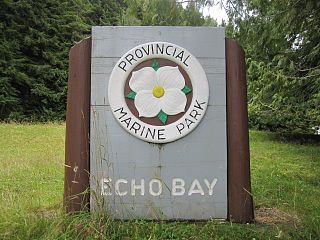
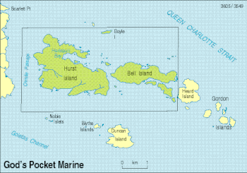
Echo Bay Marine Provincial Park is a provincial park in British Columbia, Canada, established in 1971 and containing 1.5 hectares. It is located at the bay of the same name, offshore from the community of the same name, which is the location of the Simoom Sound post office and is on the west side of Gilford Island.
Háthayim Marine Provincial Park, formerly Von Donop Marine Provincial Park, is a provincial park in British Columbia, Canada, located on the north end of Cortes Island in the Discovery Islands.
Lawn Point Provincial Park is a provincial park in British Columbia, Canada.

Marble River Provincial Park is a provincial park in British Columbia, Canada. The park is located on northern Vancouver Island. It is 14.19 km2 (5.48 sq mi) in area. The park protects an eagle nesting habitat near Quatsino Narrows in Quatsino Sound, a steelhead fishery, and an extensive waterfowl habitat. A 4.2 km (2.6 mi)-long biking or walking trail is available, as well as opportunities for wildlife viewing.
Netalzul Meadows Provincial Park is a provincial park in British Columbia, Canada. It is located in the Harold-Price watershed, about 50 km north of Smithers. The park consists of an unusual wet meadow complex, as well as a spectacular waterfall and rare plant species.
Nimpkish Lake Provincial Park is a provincial park on northern Vancouver Island, British Columbia, Canada on Vancouver Island. The park is 3,949 ha. in area and was established on 1995. It is 32 km south of Port McNeill and on the southwest side of Nimpkish Lake. Primary access is by boat launch, though radio-controlled logging roads lead to the edge of the park. Western Forest Products in Woss, British Columbia should be contacted for road advisories. The park is in the traditional territory of the Namgis First Nation.
Princess Louisa Marine Provincial Park is a provincial park in British Columbia, Canada surrounding Princess Louisa Inlet.
Rock Bay Marine Provincial Park is a provincial park in British Columbia, Canada, located on the Inside Passage at the junction of Johnstone Strait and Discovery Passage. The park contains approximately 525 ha. Rock Bay is located on the shore of Vancouver Island, immediately south of East Thurlow Island.

Rugged Point Marine Provincial Park is a provincial park in British Columbia, Canada, located at the southeast entrance to Kyuquot Sound on the west coast of Vancouver Island. It is remote and largely visited by kayakers.
Spipiyus Provincial Park is a 29.79 square kilometres (11.50 sq mi) provincial park in British Columbia, Canada. The park is north of Halfmoon Bay on the Sechelt Peninsula. It protects pockets of old-growth forest that are habitat for the marbled murrelet.
Tahsish-Kwois Provincial Park is a provincial park in British Columbia, Canada. Located west of Woss Lake, it is approximately 10,829 ha. in size.
Thurston Bay Marine Provincial Park is a provincial park on the northwest side of Sonora Island in British Columbia, Canada.
The Crooked River is a river in the Central Interior of British Columbia, Canada, beginning at Summit Lake and the community of the same name, flowing north into McLeod Lake. It is part of the drainage area of the Pack River, via the McLeod River north from McLeod Lake and which feeds Lake Williston, and therefore also part of the Peace River basin and in the Arctic Ocean drainage. South of its source at Summit Lake is the drainage basin of the Fraser River, and so of the Pacific Ocean. Crooked River Provincial Park is located close its course, on Bear Lake just south of the community of Bear Lake.