
The Oldman River is a river in southern Alberta, Canada. It flows roughly west to east from the Rocky Mountains, through the communities of Fort Macleod, Lethbridge, and on to Grassy Lake, where it joins the Bow River to form the South Saskatchewan River, which eventually drains into the Hudson Bay.

Winagami Lake Provincial Park is a provincial park in Alberta, Canada, located on three sides of Winagami Lake and accessible from Highway 2, about 30 km north of High Prairie. The park was established on November 13, 1956.

Eastern Manitoba, or the Eastman Region, is an informal geographic region of the Canadian province of Manitoba. It is bounded on the north by the Winnipeg River and Lake Winnipeg, on the east by the Manitoba-Ontario border, on the south by the Canada–US border, and on the west by the Red River. With a population of 128,855 as of the 2021 Canadian census, the Eastman Region is the second most populous region outside of the Winnipeg Metropolitan Region.

Allison Lake Provincial Park is a provincial park in British Columbia, Canada, located 28 kilometres north of Princeton, British Columbia. The park, which is 23 ha. in size, was established July 26, 1960. It is mainly a recreation area, offering camping, swimming and fishing. The park contains mostly aspen.
Arrow Lakes Provincial Park is a provincial park in British Columbia, Canada.
Bugaboo Provincial Park is a provincial park in British Columbia, Canada, located in the central Purcell Mountains.
Christina Lake Provincial Park is a provincial park in British Columbia, Canada. The lake it's on, Christina Lake, is renowned as the warmest lake in Canada.
Drewry Point Provincial Park is a provincial park in British Columbia, Canada, on the west side of Kootenay Lake, southeast of the city of Nelson.
James Chabot Provincial Park is a provincial park in British Columbia, Canada. Formerly Athalmer Beach Provincial Park, it is located in Invermere at the northeast end of Windermere Lake in the Columbia Valley region of the East Kootenay. Windermere Lake Provincial Park is located at the lake's southwestern end.
Kootenay Lake Provincial Park is a provincial park in British Columbia, Canada. It encompasses five widely dispersed parks around Kootenay Lake: Kootenay Lake Provincial Park, Kootenay Lake Provincial Park, Kootenay Lake Provincial Park, Kootenay Lake Provincial Park, and Kootenay Lake Provincial Park.
Kianuko Provincial Park is a provincial park in British Columbia, Canada.

Lockhart Beach Provincial Park is a provincial park Located 40 km north of Creston, British Columbia, Canada, on BC Highway 3A. "This park and the adjacent Lockhart Creek Provincial Park extend 3 hectares, from the sunny shores of Kootenay Lake to the headwaters of Lockhart Creek. "This small park provides the only easy access to public camping along the south arm of Kootenay Lake. An 18-site campground and day-use area are located near a sand and fine gravel beach."
Lockhart Creek Provincial Park is a provincial park in British Columbia, Canada, located adjacent to Lockhart Beach Provincial Park, 40 km north of Creston, British Columbia on the east shore of Kootenay Lake.
Okanagan Falls Provincial Park, now officially named sx̌ʷəx̌ʷnitkʷ Provincial Park, is a provincial park in British Columbia, Canada, located within the traditional territory of the Osoyoos Indian Band. Since time immemorial, the Osoyoos Indian Band's Okanagan ancestors have inhabited and cared for the lands and waters in their traditional territory. The park is also located within the town of Okanagan Falls, protecting the area around the waterfall of the same name, which lies below the outlet of Skaha Lake in the course of the Okanagan River.

Pilot Bay Provincial Park is a provincial park in British Columbia, Canada.
Porcupine Meadows Provincial Park is a 2,704 hectare provincial park in British Columbia, Canada, located north of Tranquille Lake to the northwest of Kamloops. Its name is a direct translation of the Shuswap word for this area, "pisitsoolsia", named so for the numerous porcupine in the area.

The Waputik Icefield is located on the Continental divide in the Canadian Rocky Mountains, in the provinces of British Columbia and Alberta. It is developed on the heights of the Waputik Range in the Central Main Ranges.
There are several lakes named Mud Lake within the Canadian province of Alberta.
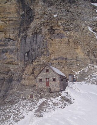
The Abbot Pass hut was an alpine hut located at an altitude of 2,925 metres (9,596 ft) in Abbot Pass in the Rocky Mountains in Alberta, Canada. It was nestled between Mount Victoria and Mount Lefroy, straddling the Great Divide, which, in this region, defines the boundary between Banff National Park in Alberta and Yoho National Park in British Columbia. While close to the border, the hut lay entirely in Banff National Park, and was the second-highest permanently habitable structure in Canada. The hut was maintained by the Alpine Club of Canada.
Falcon Lake is an unincorporated urban centre at the western end of Falcon Lake situated in the southeasternmost section of the Whiteshell Provincial Park in the Canadian province of Manitoba. It is the major entry point to the Whiteshell from the Trans-Canada Highway. Three provincially operated campgrounds, Falcon Creek, Falcon Beach and Falcon Lakeshore, picnic areas, a swimming beach and adjacent public boat launch, several cottage lot divisions and numerous tourist services make the community a favored entrance point to the provincial park. In 2003, 40% of park visitors entered the park at the Falcon Lake checkpoint.

