Related Research Articles
Banana Island Provincial Park is a provincial park in British Columbia, Canada. It is a small 10.4 hectare island in the South Thompson River, located approximately 35 kilometres east of Kamloops. There are no camping or recreational facilities, as it is an environmentally sensitive area. The island was designated as a provincial park on 30 April 1996 following recommendations from the Kamloops Land and Resource Management Plan to protect spring salmon spawning grounds and nesting grounds for several varieties of birds. It is used for nesting by Canada geese, Osprey and bald eagles, and other waterfowl and raptors. It is also a winter habitat for Tundra and Trumpeter swans. The island is vegetated with ponderosa pine and grassy undercover, and was historically used by the Neskonlith First Nation in accessing river resources.
Beatton River Provincial Park is a provincial park in the Peace River Country of northeastern British Columbia, Canada.
Bull Canyon Provincial Park is a provincial park in British Columbia, Canada, protecting Bull Canyon on the Chilcotin River, which is 7 km (4 mi) below the confluence of the Chilko River with the Chilcotin. The canyon and park are located just west of the community of Alexis Creek. Bull Canyon is part of a large volcanic plateau called the Chilcotin Group.
Cinnemousun Narrows Provincial Park is a provincial park in British Columbia, Canada, located on Shuswap Lake at the convergence of the lake's four arms.
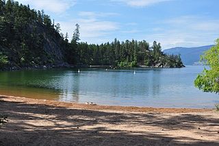
Ellison Provincial Park is a provincial park in British Columbia, Canada, located on the east side of Okanagan Lake to the south of the city of Vernon. The park contains approximately 219 hectares (2.19 km2) of land, 200 ha. of it upland, 19 ha. of it foreshore.
Eneas Lakes Provincial Park is a provincial park in British Columbia, Canada, located west of the town of Peachland, to the south of Peachland Creek. The park is approximately 1036 ha. in size and was established in 1968. The Eneas Lakes lie at the head of Finlay Creek.

Herald Provincial Park is a provincial park in British Columbia, Canada.

Kalamalka Lake Provincial Park and Protected Area is a provincial park in Coldstream, British Columbia, Canada. Located within the Okanagan region, the park encompasses a land area of about 978 hectares of pristine natural areas in the North Okanagan Regional District. Kalamalka Lake Provincial Park and Protected Area adopted its current name from Kalamalka Lake, for which it is located on its shore. During the process of entering summer, calcium carbonate forms crystals that reflect sunlight and create the vivid blue and green colours. Temperature changes in the fall and the spring sometimes create ribbons of deep blue colour in the lake, seen from the park.
Kekuli Bay Provincial Park, formerly Kalamalka West Provincial Park, is a provincial park in British Columbia, Canada, located on the west shore of Kalamalka Lake on BC Highway 97 south of Vernon. The lake is popular for waterskiing and boating, and the park includes a boat launch, as well as a campground with a view of the lake. The park was established in 1990. Its size is about 57 hectares.
Monte Creek Provincial Park is a provincial park in British Columbia, Canada, located in the locality of Monte Creek, British Columbia. Created in 1996, it is only 3 hectares in size, and protects a forested riparian area and also quiggly hole ("kekuli") sites of the Shuswap people, which have been formally studied as an archaeological site. The location was also part of the route of the Hudson's Bay Brigade Trail to the Cariboo via Kamloops from what is now the United States, as was Monte Lake in the upper basin of the eponymous creek.
Monte Lake Provincial Park is a provincial park in British Columbia, Canada, located on the east side of Monte Lake and to the south of the community of Monte Lake, British Columbia which is at the north end of the lake. About five hectares in size, it protects an area of Ponderosa pine and grasslands.
Mount Terry Fox Provincial Park is a provincial park in British Columbia, Canada. It is located in the Rocky Mountains near Mount Robson and the city of Valemount, British Columbia. The park and Mount Terry Fox, which is within the park, are named in honor of amputee long-distance runner and cancer research activist Terry Fox, a native of Winnipeg, Manitoba who grew up in British Columbia.

Niskonlith Lake Provincial Park is a provincial park in British Columbia, Canada, located southwest of the town of Chase. The park makes up an area of 275 hectares.
Upper Violet Creek Provincial Park is a provincial park in British Columbia, Canada.

Pillar Provincial Park is a provincial park in British Columbia, Canada. It is located 11 km (6.8 mi) north of Highway 97 at Falkland. The park area is 2.34 hectares and protects a stone pillar on the hillside above Pillar Lake.
Pritchard Provincial Park is a provincial park in British Columbia, Canada, located on the north side of the South Thompson River between the communities of Monte Creek, to the west, and Chase, to the east. The park lies approximately 40 kilometres (25 mi) northeast of the city of Kamloops. The park itself is split into two geographically separated sections.
Pukeashun Provincial Park is a provincial park in British Columbia, Canada, located north of the community of Scotch Creek, near the city of Salmon Arm. The park is named for Pukeashun Mountain which is within its boundaries and a major local landmark. It protects part of the Adams Plateau, the southeastern portion of the Shuswap Highland.

Shuswap Lake Provincial Park is a provincial park in British Columbia, Canada.
Sunnybrae Provincial Park is a provincial park in British Columbia, Canada, located on the northern side of the Salmon Arm of Shuswap Lake, near the city of Salmon Arm. Sunnybrae is a day use park with washrooms, picnic tables, playground and swimming area.
Oregana Creek Provincial Park is a provincial park in British Columbia, Canada, located 150 kilometres northwest of Salmon Arm, British Columbia, near Adams River. The park, which is 286 ha. in size, was established in 2010.
References
- ↑ "Truman Dagnus Locheed Park". BC Geographical Names. Government of British Columbia. Retrieved April 18, 2022.
50°13′17″N119°22′30″W / 50.22139°N 119.37500°W
| | This British Columbia protected areas related article is a stub. You can help Wikipedia by expanding it. |
| | This Okanagan-related article is a stub. You can help Wikipedia by expanding it. |