
British Columbia is the westernmost province of Canada. Situated in the Pacific Northwest between the Pacific Ocean and the Rocky Mountains, the province has a diverse geography, with rugged landscapes that include rocky coastlines, sandy beaches, forests, lakes, mountains, inland deserts and grassy plains. British Columbia borders the province of Alberta to the east; the territories of Yukon and Northwest Territories to the north; the U.S. states of Washington, Idaho and Montana to the south, and Alaska to the northwest. With an estimated population of over 5.6 million as of 2024, it is Canada's third-most populous province. The capital of British Columbia is Victoria, while the province's largest city is Vancouver. Vancouver and its suburbs together make up the third-largest metropolitan area in Canada, with the 2021 census recording 2.6 million people in Metro Vancouver. British Columbia is Canada's third-largest province in terms of total area, after Quebec and Ontario.

Victoria is the capital city of the Canadian province of British Columbia, on the southern tip of Vancouver Island off Canada's Pacific coast. The city has a population of 91,867, and the Greater Victoria area has a population of 397,237. The city of Victoria is the seventh most densely populated city in Canada with 4,406 inhabitants per square kilometre (11,410/sq mi).

Greater Victoria is located in British Columbia, Canada, on the southern tip of Vancouver Island. It is usually defined as the thirteen municipalities of the Capital Regional District (CRD) on Vancouver Island as well as some adjacent areas and nearby islands.

Ross Bay Cemetery is located at 1516 Fairfield Road in Victoria, British Columbia, on Vancouver Island, Canada. Many historical figures from the early days of the province and colony of British Columbia are buried at Ross Bay.

The Métis are a mixed-race Indigenous people whose historical homelands include Canada's three Prairie Provinces extending into parts of Ontario, British Columbia, the Northwest Territories and the northwest United States. They have a shared history and culture, deriving from specific mixed European and Indigenous ancestry, which became distinct through ethnogenesis by the mid-18th century, during the early years of the North American fur trade.

Fort Victoria, near present-day Smoky Lake, Alberta, was established by the Hudson's Bay Company in 1864 on the North Saskatchewan River as a trading post with the local Cree First Nations. The site had previously been used starting in 1862 as a Methodist Missionary site, on the location of an aboriginal meeting place. It was named Victoria Settlement, after Queen Victoria.
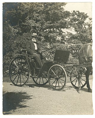
On May 26, 1896, in Victoria, British Columbia, a streetcar crowded with 143 holidaymakers on their way to attend celebrations of Queen Victoria's birthday crashed through Point Ellice Bridge into the Upper Harbour. 55 people were killed in the accident, making it one of the worst transit disasters in British Columbia. Only passengers on the left side of the streetcar escaped.
The Métis Nation British Columbia (MNBC) is a nonprofit organization representing Métis people residing in the Canadian province of British Columbia. Originally established in 1996, it was one of the members of the Métis National Council until November 2024, and is recognized by both the provincial and federal governments as the representative for the Métis in the region.

The Rock Creek Gold Rush was a gold rush in the Boundary Country region of the Colony of British Columbia. The rush was touched off in 1859 when two US soldiers were driven across the border to escape pursuing Indians and chanced on gold only three miles into British territory, on the banks of the Kettle River where it is met by Rock Creek, and both streams turn east to where in times since developed the city of Grand Forks. The first claim was filed by an Adam Beam in 1860, and the rush was on, composed mostly of Americans and some Chinese, all of whom had come overland from other workings, either at Colville or Oregon or all the way from California.
Peter O'Reilly was a prominent settler and official in colonial British Columbia who held a variety of positions, most notably as the head of a commission struck to revise and allocate Indian reserves throughout the province.

The Craigflower Manor and Craigflower Schoolhouse are National Historic Sites of Canada located in View Royal, British Columbia and Saanich near Victoria. The centerpiece of each historic site is a 19th-century building — a manor and schoolhouse commissioned by the Hudson's Bay Company to provide education and lodging for their employees. Built as part of the agricultural community Craigflower Farm, the buildings served as a focal point for the community into the modern era; they remain open to the public today as museums devoted to the colonial history of Victoria.

Victoria Harbour is a harbour, seaport, and seaplane airport in the Canadian city of Victoria, British Columbia. It serves as a cruise ship and ferry destination for tourists and visitors to the city and Vancouver Island. It is both a port of entry and an airport of entry for general aviation. Historically it was a shipbuilding and commercial fishing centre. While the Inner Harbour is fully within the City of Victoria, separating the city's downtown on its east side from the Victoria West neighbourhood, the Upper Harbour serves as the boundary between the City of Victoria and the district municipality of Esquimalt. The inner reaches are also bordered by the district of Saanich and the town of View Royal. Victoria is a federal "public harbour" as defined by Transport Canada. Several port facilities in the harbour are overseen and developed by the Greater Victoria Harbour Authority, however the harbour master's position is with Transport Canada.
Craigflower Elementary School is a public elementary school located in Victoria, British Columbia, Canada. It is the current version of the oldest schoolhouse in Western Canada, and National Historic Site, Craigflower Schoolhouse, and the third school to be called "Craigflower". The third, and current Craigflower School was constructed in the same location in 1963, and has been in constant use for more than half a century.

Fort Pelly was a Hudson's Bay Company fur trading post located in the Canadian province of Saskatchewan. The fort was named after Sir John Pelly, governor of the Hudson's Bay Company. The current village of Pelly, Saskatchewan, takes its name from the fort, and is located approximately 8 miles north of the site of the fort.

Lana Popham is a Canadian politician representing the riding of Saanich South in the Legislature of British Columbia. As a member of the British Columbia New Democratic Party, she has served in the Executive Council since 2017, currently as the Minister of Agriculture, having been reappointed to the position after having been Minister of Tourism, Arts, Culture and Sport. She was first elected in the 2009 provincial general election to the 39th Parliament and then re-elected in 2013, 2017 and 2020 to the 40th, 41st and 42nd Parliaments.
Grouard, also known as Grouard Mission, is a hamlet in northern Alberta within Big Lakes County. It was previously an incorporated municipality between 1909 and 1944.

Victoria West, commonly called Vic West, is a historic neighbourhood of the city of Victoria, British Columbia, Canada, located just west of downtown across Victoria Harbour, bordering on the Township of Esquimalt.
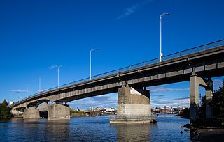
The Point Ellice Bridge, also known as the Bay Street Bridge is a major road-crossing of the Victoria Harbour in Victoria, British Columbia.
The Métis Nation of Ontario (MNO) is the government of Métis citizens and communities within Ontario that is recognized by the Canadian government. It is the democratic representative of the Métis communities represented by the MNO, with the responsibility of providing responsible and accountable self-government for its citizens and Métis communities in Ontario.


